
Santa Maria (Bulacan)
| Municipality of Santa Maria | |||
| Location of Santa Maria in the province of Bulacan | |||
|---|---|---|---|

|
|||
| Basic data | |||
| Region : | Central Luzon | ||
| Province : | Bulacan | ||
| Barangays : | 24 | ||
| District: | 4. Bulacan District | ||
| PSGC : | 031423000 | ||
| Income class : | 1st income bracket | ||
| Households : |
May 1, 2000 census
|
||
| Population : | 256.454 August 1, 2015 census
|
||
| Population density : | 2821 inhabitants per km² | ||
| Area : | 90.92 km² | ||
| Coordinates : | 14 ° 49 ′ N , 120 ° 58 ′ E | ||
| Postal code : | 3022 | ||
| Website: | Santa Maria on the site of the Province of Bulacan | ||
| Geographical location in the Philippines | |||
|
|||

Santa Maria , Tagalog : Bayan ng Santa Maria , is a Filipino municipality in the province of Bulacan , in the administrative region III, Central Luzon . According to the 2015 census, Santa Maria had 256,454 residents who lived in 24 barangays . It is classified as the first income class community in the Philippines and as urbanized .
Santa Maria's neighboring communities are Angat in the north, Pandi in the northwest, Bocaue in the west, Marilao in the south, San Jose del Monte City in the southeast and Norzagaray in the east. The topography of the city is characterized by the flatlands of the central Luzon lowlands.
There is a campus of the Polytechnic University of the Philippines in the community .
Barangays
|
|
Sons and daughters
- Bartolome Gaspar Santos (* 1967), Roman Catholic clergyman, Bishop of Iba
Web links

Santa Maria Town Hall, Poblacion

Santa Maria Town Hall

Cong. Rogaciano Mercado Memorial Hospital

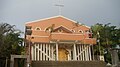
Immaculada Concepcion, Parish Church, Poblacion

altar
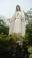
Mother of the Eucharist and Grace, San Vicente
Diocesan Shrine of Mary, Mother of the Eucharist and Grace
May Harvest Food Corporation, Caysio
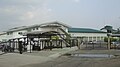
May Harvest Food Corporation
Caysio bridge


