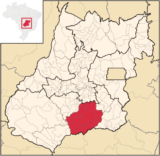
Meia Ponte microregion
| Meia Ponte microregion | |
|---|---|
| map | |
| Basic data | |
| State : |
|
| Administrative structure : | Midwest |
| State : |
|
| Mesoregion : | South Goiás |
| Time zone : |
UTC -3 summer : UTC-2 |
| Area : | 21,165.557 km² |
| Residents : | 356,781 IBGE : 2009 estimated |
| Population density : | 16.9 inhabitants / km² |
| Number of municipalities: | 21st |
| Telephone code : | +55 64 |
The Meia Ponte microregion is a region in the Brazilian state of Goiás determined by the IBGE (Instituto Brasileiro de Geografia e Estatística) exclusively for internal geostatistical purposes . It belongs to the South Goiás mesoregion and comprises 21 municipalities. Micro and meso regions are not part of the administrative structure. They existed from 1989 to 2017 and were replaced by a different geostatistical classification.
The region is named after the Rio Meia Ponte , which flows through the region from north to south and flows into the Rio Paranaíba as a right tributary .
Geographical location
The Meia Ponte microregion borders on the microregions (mesoregion):
- In the north at Goiânia ( Central Goiás )
- In the northeast at Pires do Rio ( South Goiás )
- In the southeast at Catalão ( South Goiás )
- In the south on Uberlândia and Ituiutaba (both Triângulo Mineiro e Alto Paranaíba , MG )
- In the southwest on Quirinópolis and Sudoeste de Goiás (both Sudoeste de Goiás )
- In the northwest at Vale do Rio dos Bois ( South Goiás )
Municipalities in the Meia Ponte microregion
| local community |
location | Area (km²) |
Population estimated in 2009 |
GDP in 2003 ( R $ 1,000.00) |
|---|---|---|---|---|
| Água Limpa | 452.856 | 2.111 | ||
| Aloândia | 102.160 | 2.118 | ||
| Bom Jesus de Goiás | 1,405.218 | 21,103 | ||
| Buriti Alegre | 897,394 | 8,454 | ||
| Cachoeira Dourada | 521.130 | 7,571 | ||
| Caldas Novas | 1,589,518 | 68,588 | ||
| Cromínia | 369.917 | 3,729 | ||
| Goiatuba | 2,475.107 | 32,304 | ||
| Inaciolândia | 688,398 | 5,949 | ||
| Itumbiara | 2,461,280 | 92,832 | ||
| Joviânia | 454.884 | 6,914 | ||
| Mairipotaba | 461 | 2,811 | ||
| Marzagão | 228.091 | 2.157 | ||
| Morrinhos | 2,846,191 | 40,838 | ||
| Panama | 433.759 | 2,665 | ||
| Piracanjuba | 2,405.114 | 24,033 | ||
| Pontalina | 1,428.194 | 16,687 | ||
| Porteirão | 603,917 | 3.158 | ||
| Professor Jamil | 347,464 | 3,381 | ||
| Rio Quente | 256.739 | 3,285 | ||
| Vicentinópolis | 737.251 | 6.093 |
See also
Individual evidence
- ↑ a b Estimativas da população para 1º de julho de 2009, Instituto Brasileiro de Geografia e Estatística (IBGE) (Portuguese; PDF; 5.6 MB)


