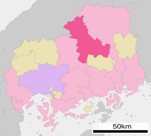
Miyoshi (Hiroshima)
| Miyoshi-shi 三次 市 |
||
|---|---|---|
|
|
||
| Geographical location in Japan | ||
| Region : | Chūgoku | |
| Prefecture : | Hiroshima | |
| Coordinates : | 34 ° 48 ' N , 132 ° 51' E | |
| Basic data | ||
| Surface: | 778.19 km² | |
| Residents : | 51,049 (June 1, 2019) |
|
| Population density : | 66 inhabitants per km² | |
| Community key : | 34209-2 | |
| Symbols | ||
| Flag / coat of arms: | ||
| Tree : | maple | |
| Flower : | Cherry Blossom | |
| Bird : | Motacilla grandis | |
| town hall | ||
| Address : |
Miyoshi City Hall 2 - 8 - 1 , Naka, Tōkaichi Miyoshi -shi Hiroshima 728-8501 |
|
| Website URL: | http://www.city.miyoshi.hiroshima.jp | |
| Location of Miyoshi's in Hiroshima Prefecture | ||
Miyoshi ( Japanese 三次 市 ) is a city in Hiroshima Prefecture in Japan .
history
Miyoshi is an old castle town that belonged to Hiroshima-han from 1720. On March 31, 1954, the place was raised to the city.
geography
Miyoshi is northeast of Hiroshima and northwest of Fukuyama .
Attractions
- Jōsei waterfall ( 常 清 滝 , Jōsei-daki )
sons and daughters of the town
- Okuda Gensō (1912-2003), painter
- Masato Ōsugi (* 1983), football player
- Kazuki Segawa (* 1990), football player
- Takuya Shigehiro (born 1995), soccer player
traffic
- Street:
- Chūgoku Highway
- National Road 54: to Hiroshima and Matsue
- National roads 183, 184, 375, 433, 434
- Train:
- JR Geibi Line : to Niimi
- JR Fukuen Line : to Fukuyama
- JR Sanko Line : to Gōtsu (closure 2017)
Town twinning
- Americus (Georgia) , since 1995
- Dingon , since 2001
Neighboring cities and communities
- Hiroshima Prefecture
- Shimane Prefecture
Web links
Commons : Miyoshi - collection of images, videos and audio files


