Takehara
| Takehara-shi 竹 原 市 |
||
|---|---|---|
| Geographical location in Japan | ||
|
|
||
| Region : | Chūgoku | |
| Prefecture : | Hiroshima | |
| Coordinates : | 34 ° 21 ' N , 132 ° 54' E | |
| Basic data | ||
| Surface: | 118.30 km² | |
| Residents : | 24,496 (June 1, 2019) |
|
| Population density : | 207 inhabitants per km² | |
| Community key : | 34203-3 | |
| Symbols | ||
| Flag / coat of arms: | ||
| Tree : | bamboo | |
| Flower : | Ume | |
| town hall | ||
| Address : |
Takehara City Hall 5 - 1 - 35 , Chūō Takehara -shi Hiroshima 725-8666 |
|
| Website URL: | http://www.city.takehara.lg.jp/ | |
| Location of Takeharas in Hiroshima Prefecture | ||
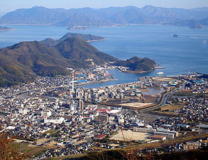
Takehara ( Japanese 竹 原 市 , - shi , literally: "bamboo plain") is a city in Hiroshima Prefecture in Japan .
geography
Takehara is located east of Hiroshima and west of Fukuyama on the Seto Inland Sea . The urban area also includes several islands in the inland sea, including Ōkunoshima , which was used for the production of poison gas in the Shōwa period.
history
The city of Takehara was founded on November 3, 1958.
traffic
Takehara is on National Road 2 to Osaka and Kitakyushu . The station is on the JR West Kure Line from Mihara to Kaitaichi (from there most trains continue on the San'yō main line to Itozaki station in Mihara in the east, or to Hiroshima or even Iwakuni in the west).
sons and daughters of the town
- Ikeda Hayato (1899–1965), Prime Minister
Town twinning
-
 : Damyang ( South Korea )
Neighboring cities and communities
The city borders on Mihara and Higashihiroshima .
Web links
Commons : Takehara - collection of images, videos and audio files


