Hatsukaichi
| Hatsukaichi-shi 廿日 市 市 |
||
|---|---|---|
| Geographical location in Japan | ||
|
|
||
| Region : | Chūgoku | |
| Prefecture : | Hiroshima | |
| Coordinates : | 34 ° 21 ' N , 132 ° 20' E | |
| Basic data | ||
| Surface: | 489.36 km² | |
| Residents : | 114,975 (June 1, 2019) |
|
| Population density : | 235 inhabitants per km² | |
| Community key : | 34213-1 | |
| Symbols | ||
| Flag / coat of arms: | ||
| Tree : | Rhododendron indicum | |
| Flower : | Japanese cherry blossom | |
| town hall | ||
| Address : |
Hatsukaichi City Hall 1 - 11 - 1 , Shimohera Hatsukaichi -shi Hiroshima 738-8501 |
|
| Website URL: | http://www.city.hatsukaichi.hiroshima.jp | |
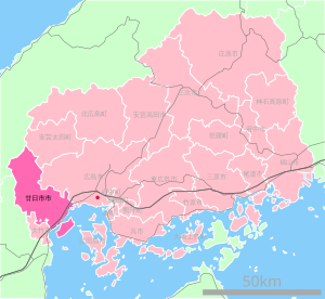
| Location of Hatsukaichis in Hiroshima Prefecture | ||
Hatsukaichi ( Japanese 廿日 市 市 ) is a city in Hiroshima Prefecture in Japan .
geography
Hatsukaichi is located east of Iwakuni and west of Hiroshima on the Seto Inland Sea .
Neighboring cities and communities
- Hiroshima Prefecture
- Yamaguchi Prefecture
- Shimane Prefecture
history
The city of Hatsukaichi was established on April 1, 1988 .
Attractions
traffic
- Street:
- Chūgoku Highway
- Sanyo highway
- National Road 2 : to Osaka and Kitakyushu
- National roads 186, 433, 434, 488
- Train:
- JR West San'yō Main Line : to Kobe and Kitakyūshū
Town twinning
-
 Masterton , since 1998
-
 Le Mont-Saint-Michel
Web links
Commons : Hatsukaichi - collection of images, videos and audio files


