Higashihiroshima
| Higashihiroshima-shi 東 広 島 市 |
||
|---|---|---|
|
|
||
| Geographical location in Japan | ||
| Region : | Chūgoku | |
| Prefecture : | Hiroshima | |
| Coordinates : | 34 ° 26 ' N , 132 ° 45' E | |
| Basic data | ||
| Surface: | 635.32 km² | |
| Residents : | 195,805 (June 1, 2019) |
|
| Population density : | 308 inhabitants per km² | |
| Community key : | 34212-2 | |
| Symbols | ||
| Flag / coat of arms: | ||
| Tree : | jaw | |
| Flower : | azalea | |
| town hall | ||
| Address : |
Higashihiroshima City Hall 8 - 29 , Saijōsakae-machi Higashihiroshima -shi Hiroshima 739-8601 |
|
| Website URL: |
www.city.higashi hiroshima.hiroshima.jp |
|
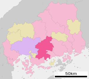
| Location of Higashihiroshimas in Hiroshima Prefecture | ||
Higashihiroshima ( Japanese 東 広 島 市 , - shi , literally: "Eastern Hiroshima") is a city in Hiroshima Prefecture in Japan .
history
The city became on April 20, 1974 by amalgamation of the four small towns ( Chō ) Hachihonmatsu ( 八 本 松 町 , -chō ), Saijō ( 西 条 町 , -chō ), Shiwa ( 志 和 町 , -chō ) and Takaya ( 高 屋 町 , -chō ) in Kamo County .
In 1992 the population exceeded 100,000.
On February 7, 2005, the small towns of Fukutomi ( 福 富 町 , -chō ), Kōchi ( 河内 町 , -chō ), Kurose ( 黒 瀬 町 , -chō ) and Toyosaka ( 豊 栄 町 , -chō ) in Kamo County and the small town of Akitsu ( 安 芸 津 町 , -chō ) incorporated in Toyota County .
Attractions
- Remains of Kagamiyama Castle ( 鏡 山城 , Kagamiyama-jō )
traffic
- Street:
- San'yō Highway
- National road 2 : to Osaka and Kitakyushu
- National roads 185, 375, 486
- Train:
- JR San'yō Shinkansen : Higashihiroshima Station, to Tokyo and Hakata
- JR San'yō Main Line : to Kobe and Kitakyūshū
- JR Kure line
education
Town twinning
Neighboring cities and communities
sons and daughters of the town
- Kazuhiko Hasegawa (* 1946), film director
Web links
Commons : Higashihiroshima - collection of images, videos and audio files


