Moorhauser Polder
|
Moorhauser Polder
|
||
| location | East of Oldenburg , Wesermarsch district , Lower Saxony | |
| surface | 99 ha | |
| Identifier | NSG WE 132 | |
| WDPA ID | 164678 | |
| Geographical location | 53 ° 10 ' N , 8 ° 19' E | |
|
|
||
| Sea level | from 0 m to 3 m | |
| Setup date | December 11, 1982 | |
| administration | NLWKN | |
The Moorhauser Polder is a nature reserve in the Lower Saxony town of Elsfleth in the Wesermarsch district . The Moorhauser Polder is a flood retention basin .
description
The nature reserve with the sign NSG WE 132 is 99 hectares and part of the EU bird sanctuary "Hunteniederung". In the west, the nature reserve borders directly on the " Bornhorster Huntewiesen " nature reserve . The area has been a nature reserve since December 11, 1982. The responsible lower nature conservation authority is the Wesermarsch district.
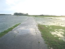
The Moorhauser Polder is east of Oldenburg and north of the Hunte . A large part of it is characterized by wet grassland , which is only used extensively as pasture land and for mowing . As a result, the nature reserve is of particular importance as a refuge for the flora and fauna in the otherwise mostly intensively used Hunten lowlands. The meadows, which are often flooded in autumn and winter, are an important resting area for migratory birds . In the west, the Wulfsgraft runs through the polder. There are also several still waters in their area.
The polder can be seen from the dike . There is an information board in the southeast.
Karl Sartorius Hut
In the north of the polder, the Ornithological Working Group Oldenburg maintains a hut named after Karl Sartorius , one of the first ornithologists in the Huntewiesen. The hut has been used for scientific bird watching for decades and was completely overhauled in 2011.
Web links
- Nature reserve "Moorhauser Polder" in the database of the Lower Saxony State Office for Water Management, Coastal and Nature Conservation (NLWKN)
- Bornhorster Huntewiesen - Moorhauser Polder. Fascinating wetlands in the Hunteniederung ( Memento from July 13, 2014 in the Internet Archive ), information brochure of the Lower Saxony State Office for Water Management, Coastal Protection and Nature Conservation (PDF, 1.3 MB)
Individual evidence
- ^ A b Moorhauser Polder , Oldenburg Tourism and Marketing GmbH. Retrieved May 3, 2019.
- ↑ Flood protection of the city of Oldenburg through a polder system , 5th BWK- Küstentag 2016, Lower Saxony State Office for Water Management, Coastal and Nature Conservation (PDF, 4.7 MB). Retrieved May 3, 2019.
- ↑ Ornithologists watch in peace , Nordwest-Zeitung , September 1, 2011. Accessed May 9, 2014.


