Mount Elgon
| Mount Elgon | ||
|---|---|---|
| height | 4321 m | |
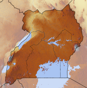
| location | Uganda , Kenya in East Africa | |
| Coordinates | 1 ° 8 ′ 0 ″ N , 34 ° 33 ′ 0 ″ E | |
|
|
||
| Type | Shield volcano | |
| First ascent | 1911 by Rudolf Kmunke and Robert Stigler | |
The Mount Elgon is an extinct volcano on the border of Uganda to the west and Kenya in the east. Its crater is about 12 kilometers in diameter. It was named after the Elgonyi ethnic group who lived on the south side of the mountain until the 20th century . Among the Maasai in Kenya his name is Ol Doinyo Ilgoon , on the Ugandan side Masaba or Masawa .
location
Mount Elgon is one of the highest mountain ranges in East Africa . It is located 100 km northeast of Lake Victoria . Despite its height, the slope is on average only about 4 degrees. The mountain area extends 80 km from north to south and 50 km from east to west. The international border runs along the Suam River , which flows to the northeast, and the Lwakaka , which flows south and forms the border to near Tororo .
- Its five main peaks are
- Wagagai (4,321 m), in Uganda
- Sudek (4,302 m), in Kenya
- Koitobos (4,222 m), in Kenya
- Mubiyi (4,211 m)
- Masaba (4,161 m)
geology
It is the oldest of the volcanoes belonging to the Great Rift Valley. It originated in the Miocene , its last major eruption occurred about 12 million years ago. It has not erupted in 3 million years. At that time, mainly liquid lava erupted , which is responsible for today's gently rising shape of the shield volcano . Moraines on the summit , which reach down to 3,500 meters, and small crater lakes indicate that the mountain was covered by glaciers in the Pleistocene (1.5 million years ago) .
geography
The Mount Elgon National Park , which extends over both countries, can be reached from the Ugandan and Kenyan sides. In addition to the two border rivers, a few other rivers have their source at Mount Elgon, including on the east side of the Nzoia , which flows into Lake Victoria. The Suam rises within the crater and flows through an accessible gorge in the caldera about 3500 meters high . There are hot springs at the bottom of the valley. This and another gorge on the Ugandan side were formed in the soft volcanic rock by the meltwater flowing off the glaciers. The protection status of the area is demonstrated by its important function as a water catchment area for Lake Turkana and Kyoga Lake justified.
On the mountain it can rain all year round, especially in higher regions, most precipitation falls between April and October. In the north and east, the annual precipitation is 1,500 millimeters, in the south and west 2,000 millimeters. The soils within the caldera and on the higher mountain flanks consist predominantly of a thin layer of dark, permanently moist loam, only in deeper regions are humus-rich, red-brown loam soils suitable for relatively intensive agricultural cultivation.
Species-rich lowland rainforest is practically non-existent. A mixed mountain forest thrives up to an altitude of 2500 meters, in which stone slices , juniper and ekebergia (a mahogany plant ) predominate in the somewhat drier north and Prunus africana and Olea welwitschii (genus olive trees ) in the south . Between 2400 and 3000 meters, light bamboo forests follow , but they do not form a closed belt. On the northern slopes, cattle pastures have led to an open grassland. A project to protect the forest reserve was started in 1996 to counter the soil degradation that has been increasingly observed since the 1970s and 1980s .
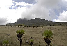
Above 3500 meters, the grass vegetation begins with the heather plants of the African high moor zone . Outside the caldera you can see occasional everlasting flowers and lobelia , inside a dwarf bush called Alchemilla elgonensis . In the caldera, Senecio elgonensis is particularly striking. Overall, the area is very rich in animal and plant species, including elephants, leopards, primates ( black and white colobus monkeys and red-tailed monkeys ) and 144 species of birds.
history
Rudolf Kmunke (1866–1918) and Robert Stigler (1878–1975) climbed the Wagagai and Koitobos on December 14, 1911, which they called Kaiser-Franz-Joseph-Spitze . This expedition included four Europeans and 200 to 250 African porters and helpers. Fredrick Jackson and Ernest Gedge had already climbed the Sudek summit in 1890 . They crossed the caldera from north to south and were traveling with 400 servants. The Scot Joseph Thomson explored the southern slope of the mountain in 1883. In 1896, the British colonial administrator Charles William Hobley (1867–1947) first circumnavigated the mountain range.
population
The Mount Elgon area has been a preferred settlement area for centuries because of its high rainfall and fertile soils. Since the 16th century, various Kalendjin groups have settled in caves on the mountain; in the following centuries they spread from the higher to the lower areas. The Nandi , Ogiek and Sabaot are among the rather slim and tall Nilotic-speaking ethnic groups in the region . Most of the Kalendjin switched from livestock (cattle breeding) to arable farming in the course of the 20th century because of the scarcity of land; First of all are the cultivation of corn and vegetables. In the 19th century, Bantu-speaking groups of the Luhya immigrated . The British referred to them as Kavirondo and supported them against the rebellious Kalendjin. They soon outnumbered them.
The Elgonyi, also counted among the Kalendjin, lived at the time of the British occupation at the end of the 19th century mainly in caves in higher forest areas and practiced cattle breeding. At the beginning of the 20th century they switched to agriculture, in 1925 their number was estimated at 5,000, with a decreasing trend. The Elgonyi were expelled from their ancestral region through the forest reserve set up by the British in 1926 at high altitudes, and some of them were forcibly relocated to Uganda. The Elgonyi became known in European circles when they were visited in 1925 by Carl Gustav Jung , who had traveled to Mount Elgon to ask them about their dreams. However, Jung learned next to nothing about the silent Elgonyi.
Current policy
The high population density and the almost complete economic dependency of all population groups on agriculture or cattle breeding has led to an acute shortage of land. Since August 2006, the people living in the area of Mount Elgon have been increasingly threatened by violence, which is carried out by armed gangs, private troops or police units. The Sabaot were settled at the foothills of the mountain during the British colonial era in the 1930s, where they met the Ogiek , who settled in higher regions . With the expansion of Mount Elgon National Park, the Ogiek were driven into the Sabaot area from 2000 onwards. The Saboat armed themselves from May 2006 to take action against the Ogiek they believed the government had preferred on the land issue. They formed the Sabaot Land Defense Force (SLDF), the Ogiek then organized themselves into the Moorland Forces , which are supported by the Kenyan security forces and are named after their original settlement area, the high moors on Mount Elgon. The Sabaot rebels are said to have received weapons from Uganda or South Sudan, which they use in the fight against the military operations carried out by the government. The civilian population is exposed to violence on both sides in the conflict, which has hardly received international attention.
Individual evidence
- ^ Project Elgon. ( Memento of February 8, 2009 in the Internet Archive ) Ecological research project, carried out in 1996 and 1997
- ^ Penny Scott: From Conflict to Collaboration: People and Forests at Mount Elgon Uganda. Union Internationale pour la Conservation de la Nature et de ses Ressources, Gland (Switzerland) 1998, p. 9
- ^ David Hinchley: Assessment of experience gained in collaborative management of a protected area: Mount Elgon National Park, Uganda. Proceedings of the International Workshop on Community Forestry in Africa. Participatory Forest Management: A Strategy for Sustainable Forest Management in Africa. ( Memento of December 24, 2015 in the Internet Archive ) (PDF; 133 kB)
- ^ Penny Scott, pp. 10-13
- ^ Rudolf Kmunke: Across Uganda - A research trip in Central Africa 1911/1912 . Dietrich Reimer (Ernst Vohsen), Berlin 1913, p. 186 ( archive.org ).
- ↑ Birgit Pack: Rudolf Kmunke. Architect, explorer and collector. afrikanistik.at (PDF; 19 kB)
- ^ Blake Burleson: Jung in Africa. Continuum, London 2005, p. 129
- ↑ Jo Collins: The Ethnic Shadow: Jung, Dreams and the Colonial Other. ejournals.org (PDF; 231 kB)
- ↑ Thilo Thielke: The forgotten war on Mount Elgon. Spiegel online, May 3, 2008
- ↑ Mount Elgon. Does anybody care? Medicins sans frontiers, May 2008 ( Memento from September 25, 2009 in the Internet Archive ) (PDF; 1.1 MB)


