Murmelbach (Wupper)
| Marmot | ||
|
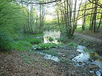
The Murmelbach behind the Murmelbachtal pilgrimage home |
||
| Data | ||
| Water code | DE : 2736398 | |
| location | Wuppertal , North Rhine-Westphalia , Germany | |
| River system | Rhine | |
| Drain over | Wupper → Rhine → North Sea | |
| source | Marpe court near Lichtscheid 51 ° 14 ′ 58 ″ N , 7 ° 12 ′ 7 ″ E |
|
| Source height | 292 m above sea level NN | |
| muzzle | at the Heckinghauser Zollbrücke in the Wupper Coordinates: 51 ° 16 '15 " N , 7 ° 13' 52" E 51 ° 16 '15 " N , 7 ° 13' 52" E |
|
| Mouth height | 163 m above sea level NN | |
| Height difference | 129 m | |
| Bottom slope | 36 ‰ | |
| length | 3.6 km | |
| Catchment area | 2.892 km² | |
|
Murmelbach floodplain |
||
|
Tributaries and hydraulic structures
|
||||||||||||||||||||||||||||||||||||||||||||||||||||||||||||||||||||||||||||||||||||
The Murmelbach , also Marper Bach , is a brook in the Wuppertal district of Barmen . After a length of 3.6 kilometers, it flows into the Wupper at the Heckinghauser Zollbrücke .
topography
The stream originates at 287 level in the old Hofschaft Marpe close Lichtscheid on the edge of the former site training area Scharpenacken . Shortly after its source, it is dammed in a chain of ponds, some of which are part of the Vorwerk Park . It flows on the edge of the Barmer plants through the Murmelbachtal, gives the old pilgrims' home Murmelbachtal its name at the foot of the Scharpenacker mountain and disappears shortly afterwards in a hollow , in which it crosses the Wuppertal district of Heckinghausen . At the Heckinghauser Zollbrücke it flows into the Wupper, just stepping once more to the surface.
history
In the Middle Ages, the brook was the border between the parishes of Schwelm and Lüttringhausen . Politically, he separated the Bergische Amt Bornefeld from the Electoral Cologne and from 1324 Brandenburg judicial district Schwelm. After the annexation of all of Barmen by the Bergisch counts as a result of the Bergisch-Mark conflict (1397 to after 1400), the brook lost its long-term border function, since the areas on both sides were combined in the Bergisch Amt Beyenburg from 1407 .
The Barmer line of the Bergische Landwehr crossed the Murmelbach west of the pilgrims' home.
natural reserve
From its source to the last reservoir, the stream is designated as a nature reserve with an area of 16 hectares. Protection took place
- for the preservation and development of communities and habitats of wild plants and wild animal species
- to preserve the ponds and the natural stream
- because of its importance for amphibians, water birds, butterflies and reptiles,
- because of its well-developed plant communities
- because of the well-developed biotope complex
- because of the valuable alluvial forest and the valuable Bachaue
At the same time, it serves as a popular local recreation area in the same area and is lined with numerous hiking trails. It connects two larger recreational areas with the Barmer facilities and the former training area Scharpenacken. The smaller, formerly private Vorwerkpark is located on the upper reaches between the two large recreational areas.
See also
Individual evidence
- ↑ a b German basic map 1: 5000
- ↑ a b river basin geographic information system of Wupperverbandes
Web links
- Nature reserve "Murmelbach (Wupper)" (W-004) in the specialist information system of the State Office for Nature, Environment and Consumer Protection in North Rhine-Westphalia

