Nêdong
| Tibetan name |
|---|
|
Tibetan script :
སྣེ་ གདོང་ རྫོང
|
|
Wylie transliteration : sne gdong rdzong
|
|
Official transcription of the PRCh : Nêdong
|
|
THDL transcription : Nedong
|
|
Other spellings: -
|
| Chinese name |
|
Traditional :
乃 東區
|
|
Simplified :
乃 东区
|
|
Pinyin : Nǎidōng Qū
|
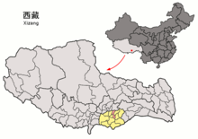
Nêdong ( Tibetan སྣེ་ གདོང་ རྫོང Wylie sne gdong rdzong ; also: Nedong ) is a municipality in the Shannan administrative district of the Tibet Autonomous Region of the People's Republic of China . It has an area of 2,184.98 square kilometers and, according to the 1990 census, 45,173 inhabitants, including 41,450 Tibetans and 3,567 Han Chinese (2000 census: 58,808 inhabitants).
In Nêdong are u. a. Thradrug and Keru Lhakhang monasteries and Yumbu Lagang fortress .
The municipality of Zêtang is the seat of the municipal district government and the government of the administrative district .
Administrative structure
At the community level, the city district consists of two large communities and five communities . These are (official spelling / Chinese):
- Zêtang municipality 泽当 泽当
- Greater community Changzhug昌珠镇
- Community Gyêrba结巴乡
- Community Sozhug索珠乡
- Community Yardoi亚堆乡
- Community Pozhang颇章乡
- Community Dopozhang多颇章乡
See also
literature
- Guojia cèhuìjú diming yánjiūsuǒ 国家测绘局地名研究所 , Xizang diming 西藏地名 / bod ljongs sa ming བོད་ ལྗོངས་ ས་ མིང (Tibetan place names) , Beijing, Zhōngguó Zàngxué chūbǎnshè 中国藏学出版社 1995, ISBN 7-80057-284 -6 .
Web links
- Info page (chinese)
Coordinates: 29 ° 13 ' N , 91 ° 47' E
