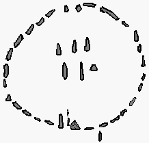
Nabta-playa
Nabta-Playa is a salt flat in the Nubian Desert with numerous archaeological sites from the Neolithic Age . The sustained for thousands of significance that the ancient caravan runway based Darb el Arba'in of Abu Simbel to the oasis Bir Kseiba ( 22 ° 41 ' N , 29 ° 54' O ) and in addition to Central Africa led by the Nabta Playa .
location
The Nabta-Playa plain is located about 100 km west of Abu Simbel and 800 km south of Cairo at an altitude of about 300 m .
Term playa
Playa is a geological term for a deposit area of dry salt lakes . A salt flat is a sedimentation area of an intermittent body of water. It continues to form inside endorheic basins in semi-arid areas, but unlike sabkhas it is surrounded by high areas.
Most of the time, Playas developed from a shallow paleo lake that was formed in the lower elevation and remained filled with water for months or all year round. Species-rich biotopes developed on such playas during several years of humid periods. Large areas of the Sahara were meanwhile savannahs with grass cover and loose trees.
Climate and prehistory
Playas in the Sahara were filled with fresh water in the periods from 320,000 to 250,000 years ago, from 240,000 to 190,000 years ago, from 155,000 to 120,000 years ago, from 90,000 to 65,000 years ago of the Pleistocene and due to a climatic shift in the monsoon zone 11,000 to 6,000 years ago of the Holocene ; the rest of the time the climate was dry and the playas were waterless.
With increasing rainfall beginning 11,000 years ago, lowlands such as the Fayyum basin , the Nabta alluvial land and the Bir Kseiba oasis could be settled. Black African populations had migrated down the Nile and had moved from there since the 10th millennium BC. Settled the eastern Sahara .
Large settlements with a high degree of organization have been found since the 7th millennium. In Nabta-Playa has been around since 6000 BC. Chr. And ceramic demonstrated. This ceramic, decorated with complex colored patterns, resembles ceramic styles in the Nile Valley near Khartoum . The archaeological findings indicate that the degree of social organization was higher than in the settlements in the Nile Valley.
In the 6th millennium, a prehistoric religion or cult developed with sacrifices of cattle, which were buried in stone-covered chambers. Whether this cult influenced the later ancient Egyptian Hathor cult is debated.
Prehistoric observatory
One of the oldest archaeoastronomical monuments in the world is located in Nabta-Playa, near a dry lake . Around the same time as the Goseck circular moat , but 1000 years older than Stonehenge , the residents erected a stone circle for calendar purposes to determine the summer solstice . The archaeological findings suggest that the region was only populated seasonally, probably in the summer when the lake had water. The determination of the solstice was therefore an important indicator for the time to move to winter quarters.
Cultural consequences
Around 5000 BC Neolithic communities of the Badari culture emerged in the upper Nile valley . They built settlements and practiced cattle sacrifices similar to those that had already been developed at Nabta-Playa in the Darb el Arba'in desert of the Sahara.
It is assumed that the cultural assets of the astronomical calendar determination , the dairy industry and the cattle cult entered the first high culture on the Nile .
literature
- Fred Wendorf, Romuald Schild: Holocene settlement of the Egyptian Sahara. Volume 1: The archeology of Nabta Playa. Springer Science & Business Media, New York 2013, ISBN 978-1-4615-0653-9 .
Web links
- Forgotten cultures: searching for traces in the desert. ( Memento from September 27, 2007 in the Internet Archive )
- Stone circle description engl. and picture on: megalithic.co.uk ; last accessed on June 16, 2017.
Individual evidence
- ↑ Wikivoyage: [1]
- ↑ Fred Wendorf, Romuald Schild: Holocene settlement of the Egyptian Sahara. Volume 1: The archeology of Nabta Playa. New York 2013, p. 584 ( restricted view on Google books ).
- ^ BJ Szabo, CV Haynes, TA Maxwell: Ages of Quaternary pluvial episodes determined by uranium-series and radiocarbon dating of lacustrine deposits of Eastern Sahara . In: Palaeogeography, Palaeoclimatology, Palaeoecology. Volume 113, No. 2, 1995, pp. 227-242.
- ↑ M. Jórdeczka, H. Królik, M. Masojć, R. Schild: Here comes the rain again… The early Holocene El Adam occupation of the Western Desert, Nabta Playa, Egypt: Site E-08-2. In: Azania: Archaeological Research in Africa, Volume 50, No. 1, 2015, pp. 3–26.
- ^ J. McKim Malville, R. Schild, F. Wendorf, R. Brenmer: Astronomy of Nabta Playa. In: Afrikan Sky. September 2007, vol. 11, p. 2, bibcode : 2007AfrSk..11 .... 2M .
- ^ A b J. McKim Malville, Romauld Schild, Fred Wendorf, Robert Brenmer: Astronomy of Nabta Playa . In: Jarita Holbrook, R. Thebe Medupe, Johnson O. Urama (Eds.): African Cultural Astronomy: Current Archaeoastronomy and Ethnoastronomy research in Africa. Springer Science & Business Media, January 1, 2008, ISBN 1402066392 .
- ↑ a b Rudolph Kuper, Stefan Kröpelin: Climate-controlled Holocene occupation in the Sahara: Motor of Africa's evolution . In: Science , Volume 313, No. 803, 2006, doi : 10.1126 / science.1130989 .
- ↑ Guy Brunton, Gertrude Caton-Thompson : The Badarian civilization and predynastic remains near Badari. British School of Archeology in Egypt, London 1928.
Coordinates: 22 ° 32 ′ 0 ″ N , 30 ° 42 ′ 0 ″ E


