Namoluk
| Namoluk | ||
|---|---|---|
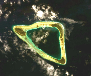
| NASA image of Namoluk | ||
| Waters | Pacific Ocean | |
| archipelago | Carolines | |
| Geographical location | 5 ° 55 ' N , 153 ° 8' E | |
|
|
||
| Number of islands | 5 | |
| Main island | Namoluk | |
| length | 6.2 km | |
| width | 3.8 km | |
| Land area | 83.4 ha | |
| Lagoon area | 7.697 km² | |
| total area | 13 km² | |
| Highest elevation | 30 m | |
| Residents | 407 (2000) | |
Namoluk is an atoll in the Micronesian state of Chuuk . Namoluk Atoll is 188 km southeast of the Chuuk Islands . The closest neighbor is the atoll Ettal (Etal) in the Mortlock Islands 50 km further southeast.
geography
The atoll has five islands that lie on the edge of the coral reef and that together have a land area of 83.4 hectares . The 7.7 km² large lagoon is 20 to 77 meters deep. The ring of the fringing reef is almost closed and boats can only enter the lagoon under optimal conditions in one or two places on the southeast side.
The total area of the atoll measures 13 km². Namoluk is one of the smallest atolls in Micronesia .
The atoll has a total of three larger and two small islands (clockwise, starting in the north):
- Namoluk (main island in the northwest, 31 hectares, inhabited)
- Lukan 1.5 hectares
- Toinom 21 hectares
- Umap 1.5 hectares
- Amas (Amwes) (southeast, 28 hectares, inhabited until the 1930s)
Only the main island of Namoluk is inhabited. With a maximum height of 30 meters, it is also the highest island in the atoll. Amas was also inhabited until the 1930s when an epidemic wiped out the entire population. Amas has not been repopulated since then, with the exception of one family. Taro is grown on the three larger islands .
There are three villages on the main island of Namoluk:
- Saponwell (northwest)
- Nukolap (center, largest village)
- Pokos (southeast)
Pokos is located directly on the lagoon. The population is also concentrated there. Taro cultivation, on the other hand, is concentrated in Saponwell at the opposite end of the island.
administration
The atoll Namoluk is also a town ( municipality ), one of eleven municipalities of statistical island region Mortlocks .
literature
- Mac Marshall: Namoluk Beyond the Reef: The Transformation of a Micronesian Community (Westview Case Studies in Anthropology), Westview Press 2008, 192 pages, ISBN 978-0-8133-4162-0
- Mac Marshall and Mark Borthwick: Consensus, Dissensus, and Guttman Scales. The Namoluk Case. Journal of Anthropological Research, Vol. 30, No. 4 (1974), pp. 252–270 ( abstract )
Web links
- Namoluk on Oceandots ( Memento from December 23, 2010 in the Internet Archive )
Individual evidence
- ^ National Geospatial-Intelligence Agency: Sailing Directions (enroute), Pub. 126, Pacific Ocean (PDF; 5.1 MB)
- ↑ Page no longer available , search in web archives: Atoll Area, Depth and Rainfall
- ^ Mac Marshall: The natural history of Namoluk Atoll, Eastern Caroline Islands. Atoll Research Bulletin, No. 189, August 6, 1975 (PDF; 14.6 MB)
- ↑ Indigenous Fresh Water Management Technologies PDF 3.23 MB ( Memento from December 5, 2004 in the Internet Archive )

