Naranjal (Pando)
| Naranjal | ||
|---|---|---|
| Basic data | ||
| Residents (state) | 426 pop. (2012 census) | |
| height | 158 m | |
| Post Code | 09-0302-0270-2001 | |
| Telephone code | (+591) | |
| Coordinates | 11 ° 35 ′ S , 66 ° 59 ′ W | |
|
|
||
| politics | ||
| Department | Pando | |
| province | Madre de Dios province | |
| climate | ||
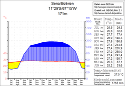
 Climate diagram Sena |
||
Naranjal is a town in the Pando department in the lowlands of the South American Andean state of Bolivia .
Location in the vicinity
Naranjal is the fourth largest town in the district ( Bolivian : Municipio ) of San Lorenzo in the province of Madre de Dios and is located at an altitude of 158 m , between the Río Beni and the Río Madre de Dios before their union near Riberalta .
geography
The town of Naranjal is located in the Bolivian part of the Amazon basin in the northern part of the country, at a distance of about 125 kilometers south of the border with Brazil .
The mean average temperature of the region is 27 ° C and fluctuates only marginally between a good 25 ° C in June / July and 28 ° C from September to November (see Sena climate diagram). The annual precipitation is about 1,750 mm, with a pronounced dry season from June to August with monthly precipitation below 35 mm, and a humidity period from December to March with monthly precipitation of more than 200 mm.
Transport network
Naranjal is located at a distance of 285 km by road southeast of Cobija , the capital of the department.
Of Cobija from 370 kilometers takes highway Ruta 13 east over Porvenir to Puerto Rico on orthon river , then on to El Sena on Río Madre de Dios and after Naranjal where a side road south to Blanca Flor branches. From Naranjal, Ruta 13 continues east to Peña Amarilla on the Río Beni and finally to El Triangulo (El Choro) , where it meets Ruta 8 .
population
The population of the village has more than doubled in the past decade:
| year | Residents | source |
|---|---|---|
| 1992 | no data | census |
| 2001 | 182 | census |
| 2012 | 426 | census |
The literacy rate among the over 6-year-olds in the municipality of San Lorenzo had risen from 82.9 percent (1992) to 84.9 percent (2001), the life expectancy of newborns was 57.9 years, and the infant mortality rate was 6.5 percent ( 1992) rose to 8.8 percent in 2001.
99.8 percent of the population of the Municipio San Lorenzo speak Spanish , 5.3 percent speak indigenous languages . (2001)
Individual evidence
- ^ INE - Instituto Nacional de Estadística Bolivia 1992
- ^ INE - Instituto Nacional de Estadística Bolivia 2001
- ↑ INE - Instituto Nacional de Estadística Bolivia 2012 ( Memento of the original from July 22, 2011 in the Internet Archive ) Info: The archive link has been inserted automatically and has not yet been checked. Please check the original and archive link according to the instructions and then remove this notice.
Web links
- Municipio San Lorenzo - General Maps No. 90302
- Municipio San Lorenzo - detailed map and population data (PDF; 1.09 MB) ( Spanish )
- Departamento Pando - social data of the municipalities (PDF; 2.42 MB) ( Spanish )
