Naxburg (mountain)
| Naxburg | ||
|---|---|---|
|
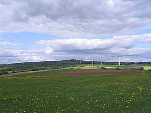
The Naxburg from the south |
||
| height | 554 m above sea level NN | |
| location | Vogelsbergkreis , Hoher Vogelsberg Nature Park , Hesse , Germany | |
| Mountains | Vogelsberg | |
| Dominance | 6.3 km → Völzberger Köpfchen | |
| Notch height | 77 m ↓ south of Ober-Moos | |
| Coordinates | 50 ° 27 '0 " N , 9 ° 23' 31" E | |
|
|
||
| rock | basalt | |
| particularities | Burgstall | |
The Naxburg is 554 m above sea level. NN high elevation in Vogelsberg , Hesse , Germany . The hill, originally called Naxberg , was the site of a castle in the Middle Ages , which was called Naxburg . After their destruction and decay, their name was transferred to the mountain.
Geographical location
The Naxburg is the highest mountain in the municipality of Freiensteinau and rises three kilometers north-northwest of the core municipality. 150 meters east of the summit, the L 3178 runs from Freiensteinau to Grebenhain from south to north . About two kilometers northwest of the Naxburg are the 30 hectare Nieder-Mooser and Ober-Mooser ponds. Immediately south of the Naxburg is a wind park with four wind turbines .
Castle
The castle , which was built on the mountain around 1290 , was already in ruins in 1338. On the summit, only a depression with two to three stair-step-like basalt stones can be seen. The location and course of the former ramparts can only be guessed at.
Landscape image
From a distance, the mountain presents itself as a little and flat elevation protruding from its surroundings. The steep summit area, which is clearly shaped as a truncated cone, is only noticeable up close due to the thick vegetation of the mountain with deciduous trees . The Naxburg is not developed for tourism. The summit can only be reached without a path.
Literature and Sources
- Culture and sports association Gunzenau eV in connection with the Lauterbach eV photo club (publisher): Gunzenau - The story of a Vogelsberg village. 1998, ISBN 3-89313-040-3 .
- Hessian Land Surveying Office: Topographic map 1: 50000: Hoher Vogelsberg. 2005, ISBN 3-89446-340-6 .
- History Association Freiensteinau eV www.blaueseck.de
Web links
- Naxburg . ATKIS map 1: 25,000 In: State History Information System Hesse (LAGIS).

