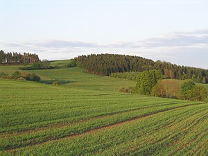
Völzberger head
| Völzberger head | ||
|---|---|---|
|
The Völzberg head from the west |
||
| height | 570.8 m | |
| location | Birstein municipality , Main-Kinzig-Kreis , Hesse , Germany | |
| Mountains | Vogelsberg | |
| Dominance | 0.4 km → White Stone | |
| Notch height | 8 m | |
| Coordinates | 50 ° 27 '29 " N , 9 ° 18' 13" E | |
|
|
||
| rock | basalt | |
The Völzberger Köpfchen is a hill in the Vogelsberg and with 570.8 m the second highest point in the Main-Kinzig-Kreis .
geography
The Völzberger Köpfchen rises 900 m north-northeast of Völzberg , a district of Birstein . The highest point is entirely in the Main-Kinzig district . The border to the Vogelsbergkreis already runs 70 m northeast of it . The Völzberger Köpfchen lies on the Rhine-Weser watershed . On the eastern slope of the mountain which rises Lüder that on the Fulda the Weser flows. To the west of the Völzberger Köpfchen spring streams of the salt arise , which flow into the Rhine via Kinzig and Main . With a dominance of only 400 m and a notch height of only 8 m, the Völzberger Köpfchen is only a slightly independent mountain. Rather, it is a knoll in the ridge that extends from the White Stone to the southeast . The fact that the Völzberger Köpfchen is mentioned more often than other mountains in its vicinity is due to the fact that it was occasionally referred to as the highest mountain in the Main-Kinzig district. In fact, this superlative belongs to the 584.6 m high Hague in the municipality of Sinntal .
flora
The Völzberger Köpfchen is forested apart from the summit area and a lane on the western slope. To the north-east of the summit there is destruction of the forest by the hurricane Kyrill .
tourism
A stage of the Vogelsberg volcano ring , a 125 km long hiking trail that circles the Vogelsberg, leads over the Völzberger Köpfchen . The summit can be reached on foot in 30 minutes from Völzberg . The view from above extends in the east to the Rhön including the Hessian skittles , in the south to parts of the Spessart and in the west to the Großer Feldberg im Taunus . The Vogelsberger Südbahnradweg runs immediately to the southwest of the Völzberger Köpfchen .
Sources and individual references
- ↑ vulkanring-vogelsberg.de ( Memento from February 14, 2013 in the Internet Archive )
- ↑ Hessenviewer

