Neuehrenfeld
|
Neuehrenfeld district 402 of Cologne |
|
|---|---|
| Coordinates | 50 ° 57 '24 " N , 6 ° 56' 9" E |
| surface | 2,550.3 km² |
| Residents | 24,405 (December 31, 2017) |
| Population density | 9569 inhabitants / km² |
| Incorporation | Apr 1, 1888 |
| Postcodes | 50823, 50825, 50827 |
| prefix | 0221 |
| Borough | Ehrenfeld (4) |
| Transport links | |
| Highway |
|
| Light rail lines | 5 13 |
| Bus routes | 140 141 142 143 |
| Source: 2017 residents . (PDF) Cologne district information | |
Neuehrenfeld is a district within the Cologne district 4 - Ehrenfeld .
location
Neuehrenfeld borders in the east and south-east on the districts of Bilderstöckchen and Neustadt Nord , in the south on Ehrenfeld and in the north-west on Ossendorf .
history
Neuehrenfeld consists for the most part of the former district "Subbelrath", which got its name from the "Subbelrather Hof" of the farming family Schlösser. The farm, which was demolished shortly after 1906, stood on the Ehrenfeldgürtel on Subbelrather Strasse. The main line of business consisted of the operation of large orchards with up to 15,000 trees. a. stretched between today's Subbelrather Strasse and Nussbaumer Strasse. After the first phase of settlement in the new suburb of Ehrenfeld , around 1860, property owners and builders, including Anton Schlösser (* 1845, † 1908), as well as the large landowner and local politician Franz Zilkens (* 1847, † 1915), began building entire streets to plan and build for citizens with homogeneous income conditions and demands on the quality of living. Schlösser turned his plots to petty bourgeois customers such as craftsmen, small merchants and skilled workers, while Zilkens sold his properties, including large parts of Eichendorffstraße and the area around St. Anna's Church, to wealthy clients.
The first house in what is now the district was built on Ottostraße in 1871 - at that time outside the city of Cologne. Around 1908, today's Siemensstrasse, Eichendorffstrasse , Röntgenstrasse and Nussbaumerstrasse were built with residential houses. High standards were set for the size and quality of the apartments and the interior of the apartment blocks was left free for gardens. One last parcel remained undeveloped and is now used by an allotment garden association that took the name of the former owner of castles. The colorful facades of the houses were richly decorated in the style of the Wilhelminian era . Since only wealthier citizens could afford such an apartment, the people of Cologne called the area, based on the occupations frequently represented by the residents, the “ink blot quarter” ( kölsch : “ink vendors”), because merchants, teachers, civil servants and higher-level employees lived here.
On 15 June 1942, the patients (elderly and in need of care) together with doctors, the staff and the remaining trustees of the Israelite asylum , which played in wooden barracks in the assembly camp Muengersdorf were held captive, with the first large deportation from Cologne in the Theresienstadt concentration camp spent .
With the large incorporation in 1888, the district in the west of Cologne belongs to the city. After a council decision in 1954, the district was officially named Neuehrenfeld.
Demographic statistics
Structure of the population of Cologne-Neuehrenfeld:
- Share of under 18s: 14.9% (2014)
- Proportion of over 64-year-olds: 15.9% (2014)
- Proportion of foreigners: 16.5% (2015)
- Unemployment rate: 7.0% (2014)
Settlement structure
In the center of the district is the Lenauplatz with the surrounding civil buildings from the late Wilhelminian era. Even if the bombings of the Second World War tore large gaps in this building stock, the reconstruction of which in the post-war years is not always seen as advantageous today, many richly decorated stucco facades can still be found in Neuehrenfeld .
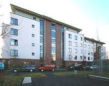
Approximately as in the so-called Chinatowns around the Takuplatz are part of the New Hren fields urban area by apartment cooperative apartment buildings, which in the age of new architecture influenced emerged. A newer residential complex west of the “Chinesenviertel” is the cooperative project Living with Old and Young , which was created in 2006 and in which intergenerational living is practiced. The name of the Chinese Quarter comes from a military victory achieved in the events surrounding the Boxer Rebellion : Corvette Captain Wilhelm von Lans conquered the Chinese Taku forts on June 17, 1900 with his gunboat Iltis . The name was given in 1913, when the former Ehrenfeld workers' housing association built the houses around Takuplatz. Taku, Iltis and Lansstrasse were also named.
Neuehrenfeld has today, not least because of the influx of migrants from many countries, a diverse range of small craft businesses, shops, restaurants, wine bars and so-called trendy bars.
Outstanding buildings in the district
Evangelical Church of Reconciliation
The construction of the church building in the form of a hexagon was started in 1963 according to the plans of the architects Dr.-Ing. F. W. Bertram and Dr.-Ing. Long started from Aachen. The church of the evangelical parish of Ehrenfeld was inaugurated on May 31, 1964. The west window represents the message of the Apostle Paul , the universality of healing, it was designed by the Ehrenfeld artist Elfriede Fulda .
St. Peter
Located on Simarplatz on Subbelrather Straße, St. Peter is the Catholic parish church for a large part of Neuehrenfeld. The church was built from 1896 in the neo-Gothic style, which was popular at the time; its architect was Theodor Roß . The landowner Anton Schlösser donated the property as well as money for the church tower (it should be higher than the neighboring tower of the St. Joseph Church in Ehrenfeld ). The three - aisled neo - Gothic brick church was consecrated on June 29, 1901. The church is also called Ehrenfeld Cathedral . The building was partially destroyed in 1944 and re-consecrated in 1948 after it was rebuilt. Glass works from 1978 by Hermann Josef Baum represent the four elements. The 62 meter high tower is one of the eye-catchers of the district. As the war only slightly damaged the church, most of the furnishings from the time it was built have been preserved.
St. Barbara
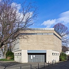
With the construction of the settlement houses in the Chinatown, the previous parish church of St. Peter became too small for the increasing number of believers. Therefore, from 1927 to 1929, the church of St. Barbara was built according to a design by the architect Karl Colombo. The repair of war damage and the changed liturgical requirements after the Second Vatican Council led to extensive renovations between 1965 and 1976. Since then, the church has given the impression of a church building from the 1960s.
St. Anna
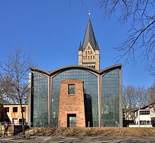
The Catholic Church of St. Anna was built in 1907 and 1908 as a three-aisled basilica according to the designs of Adolf Nöcker . After the church had suffered severe damage except for the tower in World War II, the architects Gottfried Böhm and Dominikus Böhm planned the reconstruction of the church, which was completed in 1956.
The 56 m high, colorful west tower is reminiscent of the tower of Paderborn Cathedral . During the reconstruction, the entrance portal was relocated to the east side of Christine-Teusch-Platz and completely redesigned with large glass surfaces and a curved roof supported by two conical supports. The main portal is framed by masonry from the rubble stones of the old church. On March 16, 2012, a new bell with the striking note c was cast to complete the bells.
Jewish welfare center
In 2004, the new one was in the former Jewish asylum at the Otto street in Cologne Neuehrenfeld Jewish Welfare Center opened, where a synagogue, a kindergarten, a primary school, a retirement home and the management of more than 5,000-member synagogue municipality of Cologne are housed .
See also
Individual evidence
- ^ Sunken districts The nucleus of Ehrenfeld in: Kölner Stadtanzeiger, August 6, 2014
- ↑ a b c [1] in: Kölner Stadtanzeiger from October 7, 2016
- ^ Henriette Meynen: residential buildings in Cologne-Ehrenfeld; Aspects of the development and shape of a suburb , p. 7
- ↑ Inhabitants according to selected age groups - data source: City of Cologne - offenedaten-koeln.de
- ↑ Inhabitants according to selected age groups - data source: City of Cologne - offenedaten-koeln.de
- ↑ Inhabitants by type of migration background - data source: City of Cologne - offenedaten-koeln.de
- ↑ Employed and unemployed part of the city - data source: City of Cologne - offenedaten-koeln.de
- ↑ domradio.de ( Memento from February 10, 2013 in the web archive archive.today )
literature
- Johannes Maubach: Across Ehrenfeld, Ehrenfeld History Path (Part 2). Self-published, Cologne 2002.
- Christian Schuh: Cologne's 85 districts. Emons, Cologne 2003, ISBN 3-89705-278-4
- Gerhard Wilczek: Ehrenfeld then and now. Höfer in Komm, Cologne 1967


