Lower Austrian regional hiking trail
| Lower Austrian regional hiking trail | |
|---|---|
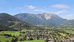
 East view of the Schneeberg massif (highest point in Lower Austria LRWW) |
|
| Data | |
| length | 1200 km |
| Markers | blue yellow |
| Type | Long-distance hiking trail |
| The highest point | Monastery coat of arms (2076 m) |
| Lowest point | Danube near Wolfsthal (138 m) |
| Level of difficulty | demanding |
| season | summer |
| Months | June to October, partially all year round |
The Niederösterreichische Landesrundwanderweg ( Lower Austria circular hiking trail for short ) is an approx. 1200 km long network of hiking trails that mostly leads around the state within the borders of Lower Austria .
history
The long-distance hiking trail was initiated by Ministerialrat Dr. Robert Wurst worked out by the Austrian Alpine Association , Naturefriends and the Austrian Tourist Club . The path was then described in a hiking guide in 1979 - as Austria's first circular hiking trail. The project was originally financed by the Lower Austrian Nature Conservation Union .
course
The route combines existing long-distance hiking trails and connects 19 Lower Austrian nature parks and the Donau-Auen and Thayatal national parks with each other. In the accompanying hiking guide of the Austrian Alpine Club , Waidhofen an der Ybbs is named as the starting point, but the circular route can be started at any point.
From Waidhofen the route leads north through the Mostviertel via Amstetten to Ybbs an der Donau , where it is crossed. Now in the Waldviertel the path runs over the Ostrong and the Ysperklamm to Schönbach , then on to the Nebelstein via Arbesbach . North of Gmund , the route turns now to the east to about Waidhofen an der Thaya to Hardegg and Retz to arrive.
In the Weinviertel you hike through Laa an der Thaya , Bernhardsthal and Marchegg to Bad Deutsch Altenburg , where the Danube is crossed again. Now on via Bruck an der Leitha into the Leitha and Rosalien Mountains . You approach the change through the Bucklige Welt , over the Semmering you get to Rax and Schneeberg . You hike back to Waidhofen an der Ybbs through the mountainous part of the Mostviertel.
One variant, coming from the north, leads via Ernstbrunn and Klosterneuburg past Vienna to the south. Originally the network of trails covered approx. 950 km, but several variants were added in the Rax-Schneeberg area.
After the circular hiking trail has been completed, a badge can be requested from the long-distance hikers section of the Austrian Alpine Association.
literature
- Fritz Käfer: Lower Austria circular hiking trail . NP-Buchverlag, St. Pölten 2001, ISBN 3-85326-185-X .
- Erika Käfer, Fritz Käfer: Landesrundwanderweg Niederösterreich - All around the federal state of Lower Austria . Ed .: Austrian Alpine Association, Section Long-Distance Hikers. 2016.
Web links
- Waymarked Trails: Lower Austrian circular hiking trail (accessed on March 24, 2020)
- Lower Austrian circular hiking trail on wandermap.net
