Schneeberg (Rax-Schneeberg Group)
| Schneeberg | ||
|---|---|---|
|
East view of the Schneeberg massif with the town of Puchberg am Schneeberg in the foreground |
||
| height | 2076 m above sea level A. | |
| location | Lower Austria , Austria | |
| Mountains | Rax Schneeberg Group | |
| Dominance | 49.3 km → Ringkamp | |
| Notch height | 1348 m ↓ Kalte Kuchl | |
| Coordinates | 47 ° 46 '33 " N , 15 ° 48' 27" E | |
|
|
||
| rock | Wetterstein lime | |
| Age of the rock | Anisium - Carnium | |
| First ascent | 1574 Charles de l'Écluse (first known tourist climb) | |
|
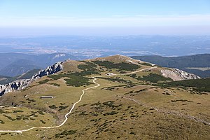
View over the high plateau "Ochsenboden" in east direction |
||
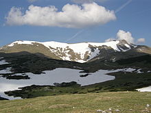
The Schneeberg is a mountain massif in the Rax-Schneeberg Group in Lower Austria , which is at 2076 m above sea level. A. high monastery coat of arms culminates. It is the highest mountain in Lower Austria and the easternmost and northernmost two-thousand-meter peak in the Alps . Its dominance of almost 50 km is only exceeded in Austria by the Grossglockner . Since 1897 the Schneeberg plateau has been made accessible by the Schneebergbahn with a rack railway.
Location and structure
The striking mountain massif made of Wetterstein limestone with several peaks between 1,800 and 2076 m has steep mountain slopes on three sides and forms a geological unit with the Rax ( 2007 m ) to the west - separated by the deep Höllental . The Hochschneeberg has a double peak: a gentle ridge connects the monastery coat of arms, which is further south-west, with the Kaiserstein ( 2061 m ) immediately above the Fischerhütte . Directly next to the summit on the monastery coat of arms there is a radio relay station of the Austrian Armed Forces for air surveillance.
The strongly structured, karstified plateau has been supplying the Austrian capital with drinking water via the 120 km long I. Vienna High Spring Water Pipeline since 1873 . With a few exceptions (route of the Schneebergbahn, Berghaus Hochschneeberg), the properties on the Schneeberg have belonged to the City of Vienna since 1935 .
Tourist development
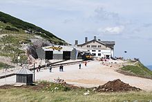
Together with the Rax, 13 km southwest ( 2007 m above sea level ), the Schneeberg is one of Vienna's local mountains and on clear days from Vienna (65 km as the crow flies). The mountain has been accessible since 1897 with the Schneebergbahn , a rack railway , up to an altitude of 1796 m . The cogwheel railway takes the “Salamander” diesel multiple unit train to the Hochschneeberg mountain station at 1,800 m above sea level in 40 minutes. At the weekend and on public holidays, it is supplemented by a steam-powered nostalgic train. All trains stop at the middle station ("Baumgartner" stop) to avoid oncoming trains. The catering business at this stop is known for its “ Schneebergbuchteln ”.
The Schneeberg and its surrounding areas are popular family excursion destinations on nice days and are summarized under the term "Schneebergland". The region with and around the Hohe Wand , the Myra Falls and the Johannesbachklamm are also included here.
The two peaks of the Schneeberg can be reached in one to two hours from the mountain station via the Ochsenboden . In 1927 the construction of a cable car to the Schneeberg was considered. The Elisabethkirche is not far from the mountain station of the Schneebergbahn .
In addition to the rack railway line, water and sewage pipes were laid to the mountain station of the railway in 2003. In 2009 the huts (Damböckhaus, Fischerhütte) were also connected. Since the entire limestone stock is an important part of the water protection area of the 1st Vienna High Spring Water Pipeline , the construction of the infrastructure was a big step towards keeping it clean. The supply of electricity and a telephone line could already be achieved in the late 1970s to early 1980s (e.g. Fischerhütte 1981).
- The footpath from Puchberg am Schneeberg mainly leads along the route of the rack railway on the south side of the elongated Hengst to the mountain station and on to the summit. This side of the Schneeberg can also be reached from Prigglitz , Payerbach , Reichenau and Kaiserbrunn further south via the Gahns or the Krummbachstein .
- From Losenheim west of Puchberg the Fadensteig leads through the north-facing Fadenwand . This leads directly to the Kaiserstein .
- From the Höllental in the west, the Schneeberg opens up through the Weichtalklamm (via ferrata, difficulty A – B) or the parallel Ferdinand-Mayr-Weg as well as the Kuhschneeberg.
- The climbs through the north-eastern flank of the mountain (Nandlgrat, Novembergrat, Herminensteig, Schneidergraben) place higher demands on the surefootedness and are in places associated with easy climbing. The Bürklesteig and Gamsgartlgrat can only be tackled with climbing equipment.
The most famous ski run leads over the Breite Ries .
The wolf in the Rax-Schneeberg spring protection area
Due to multiple evidence of the presence of wolves in the deserted Rax-Schneeberg spring protection area belonging to the City of Vienna , as well as the related sighting of a male and a female wolf, there is talk of the possibility of a resettlement there. The situation is comparable with the German Lausitz area in the 1990s. After the first wolf immigrated there, increased wolf tourism developed. Sightings of the extremely shy animal by tourists are rare.
With regard to the Rax-Schneeberg spring protection area, the real estate representative for the forestry office of the City of Vienna prepared a specially commissioned Wolf study , Wölfe - Study on behalf of the City of Vienna , which was also distributed to schools.
Important mountain huts
The summit region has several mountain huts and is visited daily by hundreds of hikers , climbers and even mountain bikers in the summer half-year.
- Almreserlhaus
- Baumgartnerhaus (ÖTK) (demolished 1982)
- Baumgartner station (middle station of the Schneebergbahn )
- Berghaus Hochschneeberg
- Damböckhaus (ÖTK) (winter room: open shelter)
- Edelweißhütte
- Fischerhütte (ÖTK) (open winter room with heating facility (electric fan with insert for € coins), emergency telephone)
- Hengsthütte (station of the Schneebergbahn)
- Heinrich-Krempel-Hut ( mountain rescue hut )
- Kienthalerhütte
- Ternitzer Hut (Grassinger Hut )
- Weichtalhaus
Popular hikes and climbs
- Salamander chairlift mountain station (Losenheim) - Fischerhütte (easy via ferrata )
- Nandlgrat
- Bürklehütte - Fischerhütte (easy via ferrata)
- November ridge
- Northern Grafensteig - Damböckhaus or Fischerhütte (easy via ferrata)
- Upper and Lower Herminensteig
- Mieseltal (Schneebergdörfl) - Damböckhaus (easy via ferrata)
- Emmisteig
- Former Baumgartnerhaus - Damböckhaus (hiking trail)
- Fischersteig
- Former Baumgartnerhaus - Schneebergbahn mountain station (hiking trail)
- Soft valley gorge
- Weichtalhaus (Höllental) - Kienthaler Hütte (easy via ferrata)
- Ferdinand Mayr way
- Weichtalhaus (Höllental) - Kienthaler Hütte (hiking trail)
The Grafensteige circle the Schneeberg at an altitude of about 1300 meters.
- Southern Grafensteig
- Kienthaler Hütte - Baumgartner stop (Schneebergbahn) (hiking trail)
- Northern Grafensteig
- Baumgartner - Edelweißhütte stop (hiking trail)
panorama
Web links
- Webcams Fischerhütte - Damböckhaus - Losenheim
- Weather on and around the Schneeberg
- Schneebergbahn - official website
- Vienna Alps - official tourism website
Individual evidence
- ↑ Land register district court Neunkirchen, cadastral community 23328 Puchberg am Schneeberg, deposit number 1076, property with an area of 5300802 m² = 5.3 km². (accessed August 12, 2018).
- ↑ Refuge at Baumgartner stop. Retrieved November 13, 2019 .
- ↑ The Schneebergland is a family country. - Family vacation in Lower Austria. Retrieved November 13, 2019 .
- ↑ All sorts of things. Austria. A cable car to the Hohe Wand and the Schneeberg. Badener Zeitung, April 2, 1927, p. 5 [1]
- ^ Fischerhütte - History. Accessed October 31, 2014
- ↑ History of the Schneebergbahn - The Schneebergbahn. Retrieved November 13, 2019 .
- ↑ Norbert Ruckenbauer: An Italian becomes a Lower Austrian - wolf sighting on the Schneeberg.
- ↑ Die Presse from October 28, 2010: Lower Austria: Wolf killed nine sheep on the Schneeberg.
- ↑ Courier January 11, 2012: Wolf groped into a photo trap on the Schneeberg.
- ↑ Contact office Wolfsregion Lausitz
- ↑ wolves. Study on behalf of the City of Vienna. Bohrmann Verlag, Vienna, ISBN 978-3-99015-014-6 .
- ^ Schmied: Book on the comeback of wolves for school libraries, Federal Ministry for Education, Art and Culture.


