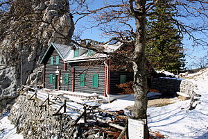
Kienthalerhütte
| Kienthalerhütte ÖTK refuge |
||
|---|---|---|
|
The Kienthalerhütte and in the background the Turmstein |
||
| location | southwest of the Schneeberg at the foot of the Turmstein; Lower Austria ; Valley location: Kaiserbrunn | |
| Mountain range | Rax Schneeberg Group | |
| Geographical location: | 47 ° 46 '10.8 " N , 15 ° 46' 57.9" E | |
| Altitude | 1380 m above sea level A. | |
|
|
||
| owner | Section “Alpine Society Kienthaler” of the ÖTK | |
| Construction type | Refuge | |
| Usual opening times | on weekends and public holidays from Easter to All Saints' Day | |
| accommodation | 7 beds, 23 camps | |
| Web link | Kienthalerhütte | |
| Hut directory | ÖTK ÖAV DAV | |
The Kienthalerhütte is a refuge of the “Alpine Society Kienthaler” section of the Austrian Tourist Club on the Schneeberg .
location
The Kienthalerhütte is located to the east at the foot of the 1416 m high tower stone, which can be climbed using a via ferrata with a difficulty level B , on the southwestern Schneeberg at the end of the Weichtal and above the Höllental .
history
The hut was built by the alpine society "D'Kienthaler", a section of the Lower Austrian Mountain Association (NÖGV) founded in 1892 ( basic owner : City of Vienna ) and officially opened on September 13, 1896. In 1936/37 the weather shelter was expanded. In 1975, a large part of the retaining wall in front of the hut slipped. This was painstakingly restored in 1977 and in 1978 a water supply line was installed from the Anna spring.
Alpine Society Kienthaler
This association was founded in 1892 as the "Alpine Society D'Kienthaler" and was a section of the Lower Austrian Mountain Association (NÖGV) based in Vienna. In 1898 the association left the NÖGV and was independent until 1938, when it was forced to join the German Alpine Association . In 1946 it joined the Austrian Tourist Club and was renamed “Alpine Society Kienthaler, Section of the Austrian Tourist Club”.
The Ferdinand-Mayr-Weg is named after Ferdinand Mayr, who was chairman of the association from 1893 and worked for almost 40 years. This leads from the end of the Weichtalklamm, about 200 meters altitude below the Kienthalerhütte, on the west side of the Weichtal back to the entrance of the Weichtalklamm (Weichttalhaus).
Ascent
- Weichtalhaus - Ferdinand-Mayr-Weg or Weichtalklamm - Kienthalerhütte, walking time 2½ to 3 hours (both red markings)
- Baumgartner station - Südlicher Grafensteig - Kienthalerhütte, walking time 4 to 5 hours (red marking)
- Edelweißhütte - Fadenweg - Kienthalerhütte, walking time approx. 1¾ hours (yellow marking)
Transition to other huts
Web links
Individual evidence
- ↑ Difficulty level according to via ferrata guide Austria ; Alpinverlag, 2nd edition, Bad Häring 2008, ISBN 978-3-9500920-8-0
- ^ Opening of the Kienthaler Hut on the Schneeberg. In: Austrian tourist newspaper. Organ of the Austrian Tourist Club , year 1896, October 16, 1896, No. 20/1896 (XVI. Year), p. 245, column 2 f. (Online at ANNO ). .
- ↑ a b c Kienthalerhütte with Ulrike and Karl-Heinz Kreiter ; Retrieved Oct. 22, 2010
- ^ Alpine Society Kienthaler: History ; Retrieved Oct. 22, 2010


