North Chin Peninsula
| North chin | ||
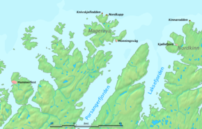
 Map with the island of Magerøya and the peninsulas Sværholt and Nordkinn (from left to right) |
||
| Geographical location | ||
|
|
||
| Coordinates | 70 ° 54 '33 " N , 27 ° 53' 48" E | |
| Waters 1 | Laksefjord , Arctic Ocean | |
| Waters 2 | Tanafjord | |
 Kinnarodden - the northernmost point of mainland Europe on the Norwegian North Kinn Peninsula |
||
The North Chin Peninsula ( Norwegian Nordkinnhalvøya ) is the northernmost peninsula on mainland Europe . It is located in the Norwegian Fylke Troms og Finnmark between the Laksefjord in the west and the Tanafjord in the east. The highest point on the peninsula is 486 m high. The approximately one kilometer wide Hopseidet isthmus connects the peninsula with the rest of the mainland.
The North Cape is a little further north (71 ° 10 ′ 21 ″ north latitude), but is located on the island of Magerøya . The northernmost point of mainland Europe on the North Chin Peninsula is called Kinnarodden ( ⊙ ) and is located at 71 ° 7 ′ 57 ″ north latitude. To get there, a 24 km hike must be undertaken, which is not without risk in bad weather. It was not until August 1989 that the North Chin Peninsula was even connected to the Norwegian road network.
On the North Chin Peninsula, there are the larger towns of Kjøllefjord (1,300 inhabitants, as of 1997), Mehamn (900 inhabitants) and Gamvik (270 inhabitants) and Sjånes (230 inhabitants) in the southeast. This is also where the border between Lebesby and Gamvik municipalities runs . Kjøllefjord and Mehamn are two stations of the Hurtigruten ships , which circumnavigate the north chin between Honningsvåg and Kjøllefjord and reach the northernmost point there.
Climate and vegetation
The warmest month of the year is August with an average temperature of 9.6 ° C. The wind is often strong, especially in winter. In January, wind with a wind force of "liten kuling" (force 5/6) or more was measured on 21 days. The "Nordkyn Strait" from Bekkarfjord to Hopseidet, which was only opened in 1989 and leads through very inhospitable areas, had to be cleared in 238 days in 1996.
At first glance, the vegetation looks very sparse and poor. But the Nordkyn Peninsula, with 350 registered plant species, is far from being as poor in vegetation as one would think. The vegetation largely corresponds to that of the southern Norwegian high mountains at heights of 1,000 to 1,500 meters. So here you can find high mountain plants side by side with beach plants.
history
The first people settled on the peninsula over 9,000 years ago. However, none of today's locations is more than 400 to 500 years old. Agriculture and fishing have always been the livelihoods of the population. A good harbor and the short distance to the fishing grounds were particularly important. The pomor trade , which was carried on until the First World War , consisted largely of a lively bartering with the Russians , where fish was exchanged for flour and other essential goods.
Around 1900 the famous whaler and inventor Svend Foyn ran his own whaling station in Mehamn. It was the largest factory of its kind in Finnmark County . However, it did not last very long. When fishermen experienced a bad fishing season in 1903, they blamed the whalers. In the “Mehamn riot” on June 2, fishermen who had traveled here tore down the factory and destroyed it. In this violent battle, soldiers had to be used to maintain law and order. The factory was never rebuilt as the whale population had fallen dramatically anyway.
