
Oberland Canal

The Uplands channel , also Oberland channel , channel Elbing-Osterode or Elbing-Elbląg Canal ( Polish Elblaskie Canal called), is located in the Oberland of Polish Warmia and Mazury . It was built from 1844 to 1860 under the direction of the royal Prussian building councilor Georg Steenke from Königsberg ( Prussia ). The engineers Wilhelm Severin and Carl Lentze , who was mainly known as the designer of the Vistula Bridge in Dirschau and who later worked on the construction of the Suez Canal , worked on the construction of the Oberland Canal .
The Oberland Canal connects several lakes such as the Geserichsee and cities in East Prussia from Iława (German: German Eylau ) via Ostróda (Osterode) to Elbląg (Elbing) to the Frischen Haff . The length of the canal is 129.8 km to Iława, while the Elbląg – Ostróda section, with which the canal is mostly identified, is 82 km long.
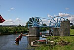
A special feature and today's tourist attraction are the five rolling mountains , on which the ships are transported overland on rail cars to cope with the height difference of 99 meters. They are designed as funicular railways powered by water wheels. The canal system is a technical monument and is a listed building.
Building history
As early as 1789 a plan was drawn up to connect the East Prussian Oberland with the Baltic Sea coast on a shorter shipping route because of its abundance of wood. The wood transport on the ship route over the Drewenz to Thorn , over the Vistula , the Nogat and the Kraffohlkanal to the Frischen Haff took more than six months and was therefore unprofitable. In 1803, the Eytwelin Regional Building Council presented the project of a canal with the bypassing of Thorn, but the construction of this was never realized. In 1825 the project was taken up again and the construction of the Prussian state parliament decided. Initially, the engineer Severin from Marienwerder was supposed to be the site manager, but he already failed in the planning phase.

Concrete planning began in 1836 by Georg Steenke , under whose direction the Seckenburg Canal was built in the Memel lowlands as early as 1833 . The employees were the engineers Severin and Carl Lentze, who was mainly known as the designer of the Vistula Bridge in Dirschau and who later worked on the construction of the Suez Canal . Steenke initially determined the canal route and considered the first hydrotechnical solutions . In the area of the legend, however, belongs that he was the then Prussian King Friedrich Wilhelm III. already this year proposed to set up a boat trip over mountains with sloping plains to bridge the difference in altitude of almost 100 m on the 9 km long canal stretch from Buchwalde (Buczyniec) to Kussfeld (Całuny) . Instead, Steenke initially planned 20 chamber locks, but this was too expensive and required a more effective solution. For this reason he made various trips, including to Belgium, Holland and Bavaria, to inspect the latest hydrotechnical systems.
After construction began, five chamber locks south of the Drausensee were completed between 1844 and 1850 . In 1850 Steenke made a trip to the USA to inspect the hydrotechnical systems on the Morris Canal in New Jersey , where, in addition to chamber locks, 23 inclined levels with wagons on which the ships were transported were set up. Steenke thought this solution was too ineffective and instead, together with his employees Severin and Lentze, constructed levels with peaks that made the chamber locks unnecessary and meant a technical innovation. The construction of the four inclined levels in Buchwalde, Kanthen, Schönfeld and Hirschfeld was completed in 1860, so that the canal could be officially inaugurated and navigated on August 31, 1860, despite the resistance from Steenke, who blocked the previous five chamber locks in the area between Kussfeld and the Wanted to replace Drausensee by another inclined plane. It was not until the period from 1874 to 1881 that the fifth inclined plane was built in Kussfeld, which was driven by a more modern water turbine.
In the period from 1921 to 1931, the canal was modernized by converting the locks, weirs and security gates and replacing the wooden structures in the locks with concrete.
The inclined planes

In addition to two conventional descent structures with locks , five rolling hills are used on a section of 9.5 km to overcome the height difference of 99.5 m above sea level. NN at 0.3 m above sea level NN. Each Rollberg is equipped with a funicular , which transports the ships to the next canal section with the help of rail cars. The funiculars are each equipped with a machine house in which the hoisting machine is located. The cable drum is driven by a reduction gear through an undershot water wheel . The later built Rollberg by Całony Nowe (Neu-Kussfeld) has an electric drive, the energy of which is supplied by a water turbine .
In order not to stress the hulls too much from bending when entering and exiting the water, the trucks in these sections are held horizontally despite the track incline. For this, the wheels are each equipped with two running surfaces. The inner running surfaces of the uphill wheels and the outer running surfaces of the downhill wheels run on the rails. Additional auxiliary rails are laid at different heights where the carriages enter the channel supports. The unused wheel treads on the route run onto these. The difference in height between the main and auxiliary rails aligns the carriages horizontally in the duct supports.
Inclined plane data
- Height refers to the height difference to be overcome up to the following canal section
- Distance denotes the section of the canal up to the beginning of the following inclined plane
| Surname | height | length | distance | built | Specialty | Coordinates | Illustration |
|---|---|---|---|---|---|---|---|
| Buchwalde (Buczyniec) | 21.5 m | 550 m | 2.1 km | until 1860 | 53.979317 N 19.618616 O |
 |
|
| Kanthen (Kąty) | 18.0 m | 450 m | 2.9 km | until 1860 | 53.996547 N 19.611803 O |
 |
|
| Schönfeld (Oleśnica) | 24.5 m | 350 m | 2.2 km | until 1860 | 54.019211 N 19.599384 O |
 |
|
| Hirschfeld (Jelenie) | 22.5 m | 510 m | 2.0 km | until 1860 | 54.033879 N 19.581231 O |
 |
|
| Kussfeld (Całuny) | 13.0 m | 450 m | not applicable | 1874-1881 | Turbine drive | 54.045557 N 19.559918 O |
 |
The gauge of this "ship railway " is given differently with 3.27 m and 3.14 m.
Drive systems of the rolling mountains
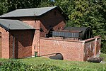
Machine house in Kąty (Kanthen) with a water wheel to drive the cable drum

Reduction gear and rope drum in the Kąty machine house
Sheaves for deflecting the steel cable at the end of the rolling mountain in Kąty


Economic importance of the canal
workload
With the construction of the Oberland Canal a faster and more profitable transport of the agricultural products of the Oberland destined for export was connected, such as wood, animal skins and long pines from Taberbrück (Tabórz), which were in demand as masts in shipbuilding. After the canal went into operation in 1860, around twelve to twenty ships passed through the canal every day. Steenke noted in his diary in 1862 that there were 57 ships in one day. Since the construction of a railway line , there has been a gradual decline in occupancy from 1893. While in 1913 goods with a weight of 107,486 tons were still transported across the canal, in 1920 it was only 69,481 tons, in 1925 34,951 tons, while the transport volume rose again to 49,778 tons in 1927.
tourism
The canal became a destination for excursions soon after it was put into operation because of its technical features and the idyllic landscape. As early as 1864, before the fifth inclined level was built, Bernhard Olbert traveled the canal out of local history and published a description of his journey.
In 1901, Robert Dorr described the beginnings of tourism in a travel guide about the region around Elbing, whereby the travelers initially traveled as passengers on the barges:
“… These steamships floating on the canal belong to the A. Zedler company. It is advantageous to ask carefully beforehand and also to ask the captain of the chosen ship to take the necessary food and drinks for the passengers, because the ships are used to transport goods. Later we start the journey at 5 o'clock in the morning, for example using the steamboat Bertha , initially on the Elbing River and then over the entire Drausensee. […] The fairway goes even further into a canal with a path on one side for towing, running on the wall with willows. Large areas of reeds and rushes stretch behind the walls. Such a landscape extends to Kleppe, where the first inclined plain appears in Neu Kussfeld. Then come the next sloping plains, known by the locals as mountains on wheels , in Hirschen, Schönfeld, Kanthen and Buchwalde. "
It wasn't until 1912 that professional tourism began with excursion boats from the Adolf Tetzlaff shipping company from Osterode . While the canal was initially mainly used for school and company trips with a local history or technical aspect, more and more individual travelers were added, so that the tourist incentive was increased through the construction of guest houses and organized trips with excursions in the area. The tourism business proved to be lucrative in the years after the First World War , so the fleet of excursion boats was expanded. For example, the MS Konsul , which went into operation in 1927, was 30 m long and 4.25 m wide and could accommodate 185 people and reached a top speed of 25 km / h. A rival company, the Munter shipping company from Saalfeld , came into being as early as 1920 .

During the Second World War , shipping on the canal was stopped. In 1948, however, it was resumed at the instigation of the shipowner Tetzlaff (1888–1952) after a railway repair shop had built a new one to replace the destroyed drive wheel of the inclined plane in Buchwalde. Nevertheless, little attention was paid to tourism on the canal in the following years. This situation only changed from 1992 when the city of Ostróda took over the operation of the canal and the protection of the ecosystem in the canal area.
The canal is once again used by excursion boats according to the schedule, with the inclined plains in particular being a tourist attraction and being crossed by more than 30,000 passengers annually (as of 1999) with an increasing tendency ever since. In the winter months, operations are suspended from the end of September to May 1st.
Due to renovation, the canal could only be used on sections in 2013 and 2014.
literature
- Dariusz Barton: The Oberland Canal . MW, Sztutowo 2010, ISBN 978-83-8801558-8 (Polish: Kanał Elbląsko-Ostródzk . Translated by Wlodzimierz Mengel).
- Bernhard Ohlert : Sketches from Old Prussia. I. The Oberland Canal . In: Old Prussian monthly . tape 1 . Königsberg 1864, p. 289-312 ( books.google.de [accessed October 27, 2013]).
- Tadeusz Peter: The Oberland Canal . AFW “Mazury”, Olsztyn 2000, ISBN 83-8952379-5 (Polish: Kanał Ostródzko-Elbląski . Translated by Maria Anielska-Kołpa).
- Walter Strauss: Of iron horses and paths . Hanover 1924.
Web links
Individual evidence
- ↑ Strauss, fig. 444.
- ↑ a b Dariusz Barton: The Oberland Canal. 2010, p. 4.
- ↑ Dariusz Barton: The Oberland Canal. 2010, p. 21.
- ↑ Tadeusz Peter: The Oberland Canal. AFW Mazury Olsztyn, p. 5; Literal quote: "a monument of hydrographic art and is under conservation protection".
- ↑ A similar construction is in Canada on the Trent-Severn waterway , at the Big Chute Marine Railway descent structure
- ↑ a b Dariusz Barton: The Oberland Canal. 2010, p. 8.
- ↑ Dariusz Barton: The Oberland Canal. 2010, p. 9.
- ↑ a b Dariusz Barton: The Oberland Canal. 2010, p. 10.
- ↑ Dariusz Barton: The Oberland Canal. 2010, pp. 10-11.
- ↑ a b Dariusz Barton: The Oberland Canal. 2010, p. 11.
- ↑ Historical recordings from the time before can be found in Strauss, figs. 444–448.
- ↑ Tadeusz Peter: The Oberland Canal. ISBN 978-83-89523-79-2 , scheme of the Oberland Canal, p. [49].
- ↑ Dariusz Barton: The Oberland Canal . Sztutowo 2010, p. 24.
- ↑ Tadeusz Peter: The Oberland Canal . AFW Mazury , Olsztyn, p. 17.
- ↑ Strauss, fig. 444.
- ↑ Strauss, p. 70.
- ↑ Tadeusz Peter: The Oberland Canal. ISBN 978-83-89523-79-2 , p. 6.
- ↑ a b c Dariusz Barton: The Oberland Canal. 2010, p. 12.
- ↑ Tadeusz Peter: The Oberland Canal. ISBN 978-83-89523-79-2 , p. 17.
- ↑ Inn between the Drausensee and the first inclined plane, see Dariusz Barton: The Oberland Canal. 2010, p. 15.
- ↑ Complete quote from Dariusz Barton: The Oberland Canal. 2010, pp. 12-13.
- ↑ a b Dariusz Barton: The Oberland Canal. 2010, p. 13.
- ↑ Tadeusz Peter: The Oberland Canal. ISBN 978-83-89523-79-2 , p. 19.
- ↑ Oberland Canal in Osterode and shipowner Tetzlaff. In: East Prussia. Retrieved August 17, 2012 .
- ↑ Tadeusz Peter: The Oberland Canal. ISBN 978-83-89523-79-2 , p. 27.
- ↑ Tadeusz Peter: The Oberland Canal. ISBN 978-83-89523-79-2 , pp. 28-29.
- ↑ See Tadeusz Peter: The Oberland Canal. ISBN 978-83-89523-79-2 , p. 29.
- ↑ Brigitte Jaeger-Dabek: Oberland Canal: from May 2015 it will again be navigable with passenger ships. September 23, 2014, accessed June 2, 2015 .
Coordinates: 54 ° 1 ′ 28 ″ N , 19 ° 35 ′ 52 ″ E