Ofenberg tower
| Ofenberg tower | |
|---|---|
| Tower type: | Observation tower |
| State : | Germany |
| State : | Hesse |
| Administrative region : | kassel |
| County : | District of Kassel |
| Location : | Wolfhagen |
| Location : | Ofenberg , Habichtswald Nature Park |
| Geo coordinates : | 51 ° 19 '39.3 " N , 9 ° 11' 24.3" E |
| Site altitude: | 372.5 m above sea level NHN |
| Tower height: | approx. 20 m |
| Number of steps : | 101 |
| Viewing platform height: | - at 17.37 m tower height - 389.87 m above sea level NN |
| Building material : | Bricks , steel and reinforced concrete |
| Construction time : | 1963 to 1964 |
| Inauguration : | July 26, 1964 |
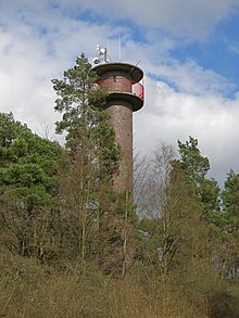
The Ofenberg Tower is an approximately 20 m high observation tower near Wolfhagen in the district of Kassel , Hesse ( Germany ).
Geographical location
The Ofenberg tower is located in the Habichtswald Nature Park on the Ofenberg ( 372.5 m above sea level ), which rises directly east of the core city of Wolfhagen and a little west of the Philippinenburg locality of the Wolfhagen district of Philippinenburg and -thal .
Tower description
"The Ofenberg Tower was built at the suggestion and cooperation of the Tourist Association under Karl Abel and the City of Wolfhagen in 1963/64 and opened to the public with the first Ofenberg Festival on July 26, 1964" .
The tower has a diameter of almost three meters and is clad on the outside with brick clinker , inside it is plastered white. From the entrance on the west side, a concrete spiral staircase with 101 steps leads to the roofed viewing platform , which is attached to the tower in a ring. There are various antennas on the roof of the tower.
The view from its viewing platform, which is 17.37 m high or 389.87 m above sea level. NN is increasingly restricted by growing trees in the area, especially to the north and northeast. The view extends to the Großer Bärenberg , the Habichtswald telecommunications tower , the Isthaberg , the Weidelsburg , the Lange Wald and parts of Wolfhagen. When the view is clear, the Rothaargebirge can be seen in the west .
Transport links
Like the “Wolfsschänke” forest restaurant located just below the tower or the Ofenberg summit, the Ofenberg tower can be accessed via the road leading up to the summit or via forest and hiking trails.
panorama
Web links
Individual evidence
- ↑ a b Map services of the Federal Agency for Nature Conservation ( information )
- ↑ a b c d e f g h Photo of the information board at the Ofenberg tower (July 1984, Wolfhagen Tourist Office)


