Weidelsberg
| Weidelsberg | ||
|---|---|---|
|
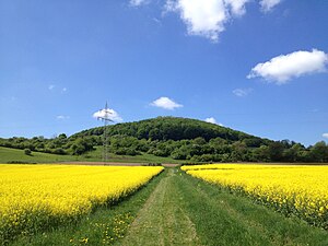
View from a field near Ippinghausen |
||
| height | 492.3 m above sea level NHN | |
| location | near Ippinghausen , Kassel district , Hesse , Germany | |
| Mountains | Waldecker Wald in the West Hessian mountainous region | |
| Coordinates | 51 ° 16 '23 " N , 9 ° 8' 40" E | |
|
|
||
| Type | volcano | |
| rock | basalt | |
| Development | Driveway to the north slope | |
| particularities | Location of the Weidelsburg ruins | |
The Weidelsberg is 492.3 m above sea level. NHN high mountain of the eastern roofing of the Waldecker Forest near Ippinghausen in the northern Hessian district of Kassel . Its widely visible feature is the ruins of the Weidelsburg on its summit .
geography
location
The Weidelsberg is part of the eastern roofing of the Waldecker Forest in the western part of the Habichtswald Nature Park . It rises south above Ippinghausen , a southern district of Wolfhagen , to whose urban area the mountain belongs. About 170 m below its summit flows the Eder- tributary Elbe , which, coming from the south-west, flows past the mountain to the north through Ippinghausen and then bends south towards Naumburg ; The small Elgersbach rises south-south-west of the crest and flows south-eastwards towards the Elbe. The steeply rising mountain is forested on its highlands, its lower slopes are partly used for agriculture.
Natural allocation
The Weidelsberg is a singularity in the natural spatial main unit group West Hessisches Bergland (No. 34) on the border of the main units Waldecker Wald (340 2 ) in the west and Ostwaldecker Randsenken (341) in the east and on those of their natural areas Langer Wald (340 2 .5 ) in the north-west, Alter Wald (340 2 .6) in the south-west and Ippinghäusergrund (with Rauenstein) (341.40; counting as part of the Naumburg valley and ridge ; 341.4) in the north-north-east through east to south-south-east.
Weidelsburg
On the top of the mountain are the ruins of the Weidelsburg , which dates back to the 12th century , of which remains of walls, palas and towers as well as arches and a large part of the kennel are still present. The panoramic view of the Habichtswald Nature Park can be enjoyed from the East Palas - including down to Ippinghausen.
Transport links and hiking
The Weidelsberg summit can be reached, for example, from a hiking car park on its northern slope, which can be reached via a road starting a little south of Ippinghausen on the state road 3214 ( Weidelsburgstraße ) leading to Naumburg , on forest and hiking trails that climb steeply to the summit and with it run to Weidelsburg. The hiking trails Märchenlandweg , Studentenpfad and Habichtswaldsteig and also the extra tour H8 of the Habichtswaldsteig, with its extra tour H7 running over the west and east flanks, lead over the summit . In addition, the Eco Path Archeology Naumburg and Hessenweg 8 lead over the mountain; Hessenweg 7 runs past it north .
gallery
Web links
Individual evidence
- ↑ a b Map services of the Federal Agency for Nature Conservation ( information )
- ↑ Martin Bürgener: Geographical Land Survey: The natural spatial units on sheet 111 Arolsen. Federal Institute for Regional Studies, Bad Godesberg 1963. → Online map (PDF; 4.1 MB)
- ↑ Eco path Archeology Naumburg , on eco-pfade.de


