Omo (river)
| Omo | ||
|
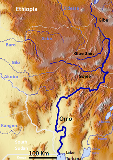
Course of the Omo and its tributaries |
||
| Data | ||
| location | in the southwest of Ethiopia |
|
| River system | Omo | |
| Source height | approx. 2400 m | |
| muzzle | in the Turkana Sea coordinates: 4 ° 34 ′ 9 " N , 36 ° 1 ′ 54" E 4 ° 34 ′ 9 " N , 36 ° 1 ′ 54" E |
|
| Mouth height | 375 m | |
| Height difference | approx. 2025 m | |
| Bottom slope | approx. 2.7 ‰ | |
| length | 760 km | |
| Right tributaries | Gojeb , Gibe , Gibe Shet | |
| Medium-sized cities | Soddo (nearby) | |
| Communities | Omorate | |
The 760 km long Omo is a river in the southwest of Ethiopia ( East Africa ).
course
The year-round water-bearing river has its source west of Addis Ababa and east of Nek'emte in the Ethiopian highlands . The mineral spring of Wolliso is located in the headwaters of the Omo . It flows mainly in a southerly direction. The southern part of the river, i.e. its lower reaches, forms the border between the region of the southern nations, nationalities and peoples and the Oromiyaa region ; there it also forms the eastern border of the Omo National Park . After flowing through the Mago National Park , the Omo flows into Lake Turkana shortly after the northern border with Kenya .
use
Hydropower
The Omo is to be expanded with several hydropower plants ( Gilgel Gibe I to V). Of these, Gibe I, II and Gilgel Gibe III are already in operation, Gibe IV and V are planned. In July 2006 the Ethiopian government signed a contract with the Italian company Salini Impregilo for the construction of Gilgel Gibe III. The associated power plant went into operation in October 2015.
Human rights organizations such as Survival International assume that the construction not only threatens the environment in the Omo Valley, but also the livelihoods of several hundred thousand members of indigenous groups in Ethiopia and Kenya.
Industry, agriculture
A gigantic sugar cane plantation in the Omo Valley, set up by the country's authoritarian government with ambitious goals under Chinese leadership, is to cover 250,000 hectares , including a third of the area of the Omo National Park , in addition to the construction of new industrial facilities . It will also deprive the nomadic approximately 10,000 Mursi of their livelihood.
ethnology
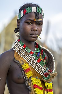
Many Ethiopian tribes live along the Omo, e.g. B. the Arbore , Bodi , Dassanetch (Geleb), Hamar , Kara , Mursi , Nyangatom (Bume) and Surma . Many of them speak one of the omotic languages named after the river .
Paleoanthropology
The valley on the lower reaches of the Omo plays a major role in the planned tourist development of Ethiopia. It belongs since 1980 to the world heritage of UNESCO because of paleoanthropologists - many - especially on the slopes along the river hominin were recovered fossils. Among other things, the fossils Omo 1 and Omo 2 were recovered here, which are ascribed to early anatomically modern humans ( Homo sapiens ) and, with an age of at least 130,000 years (according to more recent dating, probably even 195,000 years), are among the oldest finds of the species .
Protected areas
The aforementioned Omo National Park , with 4,068 km² the largest in Ethiopia, is one of the richest game but the least visited national parks in Africa.
Web links
- Entry on the UNESCO World Heritage Center website ( English and French ).
- omovalley.com
Individual evidence
- ^ Gregory Poindexter: Power generation begins at 1,870-MW Gibe III hydroelectric project in Ethiopia . Communication from October 14, 2015 on www.hydroreview.com (English, PDF)
- ↑ survivalinternational.de: Dam construction and way of life of indigenous peoples in the Omo valley
- ↑ deutschlandradiokultur.de , Weltzeit , April 28, 2016, Josepha Elmar: Nomads should settle down (April 30, 2016)
- ^ Francis Clark Howell : Hominidae. Chapter 10 in: Vincent J. Maglio and H. Basil S. Cooke (Eds.): Evolution of African Mammals. Harvard University Press, Cambridge (MA) 1979, pp. 154-248, ISBN 978-0-67427075-6


