
Places of remembrance (Bavarian Quarter)


The monument " Places of Remembrance in the Bavarian Quarter : Exclusion and Disenfranchisement, Expulsion, Deportation and Murder of Berlin Jews from 1933 to 1945" was designed by the artists Renata Stih and Frieder Schnock and inaugurated on June 11, 1993. The unusual area monument is located in the Schöneberg district of Berlin in the Tempelhof-Schöneberg district (to be reached with the U4 and U7 underground lines , Bayerischer Platz underground station ). It essentially consists of 80 signs designed on both sides (text and image pages). The text pages show the content of National Socialist laws and ordinances that promoted the disenfranchisement of Jews in Germany.
The Bavarian Quarter
Between 1898 and 1908, the Berlinische Boden-Gesellschaft built home-style houses with spacious apartments on the newly developed site. The streets were given Bavarian place names. The first residents were mostly well-off citizens, the proportion of Jewish residents was above average - in all of Schöneberg there were more than 16,000 in 1933, a large but not exactly known number of them lived in the Bavarian Quarter . After a long process of increasing oppression of the Jews by the National Socialist regime , the first deportations began in 1941, and from the spring of 1943 the Jews who were forced to work were also arrested at their workplaces and deported. On May 19, 1943, the district and all of Berlin were, in the language of the persecutors, " free of Jews ".
Search for clues
Even decades after the end of National Socialism , hardly anything was reminiscent of the district's Jewish history - with the exception of a stone memorial on the former site of the synagogue and a reference to the house in which Albert Einstein lived from 1918 until he emigrated in 1933. In 1983 a group of interested residents began researching the history of their neighborhood before and during the Holocaust . A large number of documents of all kinds were found - land deeds, private letters and diaries, photographs, and documents from the Secret State Police (Gestapo) on the deportations . In this way the history of most of the houses could be reconstructed. The results of the research could be seen in an exhibition of the Schöneberg Art Office under the title “Living in Schöneberg / Friedenau 1933–1945”.
In 1988 a resident of the Bavarian Quarter began to determine the names of those who were victims of the " Aryanization ". After a year of work, he had found more than 6,000 names, partly thanks to the precise lists that documented how Jewish property was expropriated and distributed. This material was also brought to the attention of the district administration. The Schöneberg District Assembly then decided to erect a memorial for the murdered Jews in the district.
The monument
In June 1991 the Berlin Senate and the Schöneberg Art Office called for the first stage of an ideas competition. 96 entries were received from all over Berlin, and the jury made up of artists, town planners , historians and a representative of the Jewish community selected eight finalists. After another consultation, on April 1, 1992, Renata Stih and Frieder Schnock's proposal for implementation was accepted without a dissenting vote. The two artists have dealt with forms of memory in the cityscape in theory and practice and have developed various projects for public spaces. With their work in the Bavarian Quarter, they wanted to make visible the conditions that had led to the extermination of the Jewish residents; It was intended to show that there was no sudden, inevitable event here, but rather a creeping process of dozens of regulations and laws - some of them insignificant at first glance - integrated into everyday life, which after a number of years led to deportation and mass murder . The project consists of 80 boards, each 50 cm × 70 cm in size, distributed over the entire Bavarian quarter and attached to the street lighting masts at a height of around three meters. Each of the panels bears text dated on one side, referring to anti-Semitic measures, and a simple illustration on the reverse.


One week before the inauguration of the monument on June 11, 1993 - an exhibition of the designs had taken place and the invitations had been sent - the artists and two skilled workers began installing the 80 signs on the street lighting poles. Before that they had obtained 80 permits for the installation of the 80 signs and the responsible building senator Nagel ordered the short-term replacement of some ailing lighting masts, as the stability was not guaranteed. During the assembly of the third sign with the cat (text: "Jews are no longer allowed to keep pets. February 15, 1942") a resident in Barbarossastraße opened the window and shouted: "Get rid of you Jewish pigs!" After the 17th sign was attached the state security stepped in and the two skilled workers were "conscripted" in order to dismantle the signs again and to deposit them in an evidence cellar together with weapons and drugs. Residents had alerted the police about "anti-Semitic signs" and the alarmed State Secretary said: "The limits of good taste have been exceeded!" After a crisis meeting with the chairman of the Jewish community, the building senator and the district mayor, it was decided to put one under each of the 80 boards to attach a small additional sign on which the monument function of the signs is explained.
For some of the signs, locations were chosen whose current environment corresponds to the historical content. In front of the brick facade of the Heilsbronnen Church in Heilbronner Strasse, one can read: “The baptism of Jews and the conversion to Christianity has no bearing on the race question . October 4, 1936 ". At a children's playground on the same street: “Aryan and non-Aryan children are not allowed to play with each other. 1938. “In a certain section of the street it says:“ Streets with names of Jews will be renamed. Haberland Strasse, named after the founder of the Bavarian quarter , was renamed Treuchtlinger and Nördlinger Strasse. 7/27/1938 "; in the meantime the renaming has been reversed, but only for the Nördlinger Strasse section and against vigorous protests by residents living there. A sign in front of a post office on Bayerischer Platz bears a private text that tragically misjudges the actual situation of the person writing: “Now the time has come, tomorrow I have to leave u. of course that hits me very hard; [...] I will write to you [...] Before the deportation, January 16, 1942. "
The formal design of the signs follows simple rules. The concise text, in black and white, is clearly structured. The other, colored side shows simple representations in what the artists call the “ aesthetics of normality”, again in the restrained gesture of public announcements or a lexicon of images . Texts and images are linked in terms of content in different ways. Sometimes the reference is very direct, for example the illustration of an empty ashtray and the text “Jews are no longer allowed to cigarettes or cigars. June 11, 1942 ". In other cases there is a clear, sarcastic contradiction between the image and the text, for example in the case of the image of a door on which a painted card wishes "a warm welcome". The corresponding text stated on January 29, 1936 that public notices with extremely anti-Jewish content should be removed in order not to make an unfavorable impression on foreign visitors - formulations such as "Jews are not wanted here" are sufficient; 1936 was the year of the Summer Olympics in Berlin. Still other signs use signs that were in use like this or similar after 1945: “U” ( underground ), “H” ( bus stop ) or “DR” ( Deutsche Reichsbahn ); the texts overleaf relate to drastic bans on local and tourist traffic. A single text is not annotated graphically, only a black area can be seen on the back; the text refers to October 23, 1941, the day on which all further emigration was banned.
The 80 signs are placed in a small urban space. This creates visual connections between them that can induce those interested to systematically hike through the memorial in the Bavarian Quarter. In this context, three larger information boards are helpful, which are set up at the Schöneberg Town Hall, at Bayerischer Platz and in front of a school on Münchener Strasse near Hohenstaufenstrasse. Two city maps are superimposed here in such a way that the differences in the development of the Bavarian Quarter in 1933 and 1993 can be seen through different colored contours. The extensive destruction of the area in the Second World War also becomes clear. Green dots show the locations of all individual signs on the area monument.

Remembering prohibitions when going to school. Text page.

Remembering prohibitions when going to school. Image side.
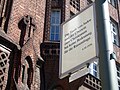
Recall the importance of the "race question".
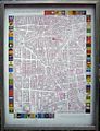
Overview board for the monument.


Overall, the seemingly harmless, inconspicuous panels in the places of remembrance give an intense impression of the repression to which the Jewish inhabitants were subjected between 1933 and 1943, of the gradual destruction of their social existence that preceded physical annihilation. The intended effect of the memorial also includes considerations that go beyond participation in the historical fate of the Jews. The observer should be asked uncomfortable questions: How did the non-Jewish neighbors deal with all this at the time, was it possible not to notice anything about professional bans, expropriations, the yellow star on the clothes, the barracks in "Jewish houses", the deportations? How would today's observer have behaved then? How does he relate to today's signs of xenophobia?
The current condition of the monument is often felt to be unsatisfactory. On the 15th anniversary of its inauguration, the daily newspaper (taz) recalled in an article dated June 9, 2008 the recognition that the new, decentralized memorial had found in Germany and abroad and named a number of current deficiencies. Many of the panels are damaged, others have completely disappeared; The places of remembrance in the Bavarian Quarter are hardly mentioned in city guides; they are not mentioned in the memorial list in the documentation center of the Holocaust memorial . The publication on the memorial has been available again since the end of 2009 and the Berlin Senate has announced the funds for the restoration of the memorial, which was inaugurated in 1993.
At the end of 2017, all damaged signs were replaced and the accompanying publication, which has since been out of print, is available in time for the 25th anniversary of the monument in 2018.
literature
- Renata Stih, Frieder Schnock: Places of Remembrance / Places of Remembrance in Berlin . Stih & Schnock, Berlin 2009. ISBN 978-3-00-030284-8 (German, English), 32 pages, including folding plan / map (bugrim.de) - with essays by Barbara Straka (German) and Caroline Wiedmer (English ), Illustration of all 80 signs (picture and text) and unrealized drafts for further signs.
- Places of remembrance, The memorial in the Bavarian Quarter / Jewish everyday life in the Bavarian Quarter . Schöneberg Art Office, Schöneberg Museum in collaboration with the House of the Wannsee Conference Memorial (publisher), Berlin 1994/1995.
- Ruth Federspiel, Ruth Jacob (ed.): Jewish doctors in Schöneberg - topography of a displacement . ISBN 978-3-942271-76-9 , Berlin 2012, 128 pages, brochure with flaps, 34 illustrations.
- Herbert Mayer: History lesson in the Bavarian Quarter . In: Berlin monthly magazine ( Luisenstädtischer Bildungsverein ) . Issue 4, 1998, ISSN 0944-5560 , p. 73-78 ( luise-berlin.de ).
Web links
- Andreas Stirn: The monument in the Bavarian Quarter. German Historical Museum
- Caroline Wiedmer: Remembrance in Schöneberg . About the memorial on the website of Renata Stih and Frieder Schnock
- Kito Nedo: Places of Remembrance . In: art-magazin , October 7, 2008
Individual evidence
- ^ A b Brigitte Werneburg: Poor Berlin . In: taz , June 9, 2008.
- ^ Caroline Wiedmer: Remembrance in Schöneberg . Paragraph 4 (English) Retrieved July 26, 2008
- ^ Caroline Wiedmer: Remembrance in Schöneberg . (English)
- ^ Herbert Mayer: History lesson in the Bavarian quarter . In: Berlin monthly magazine ( Luisenstädtischer Bildungsverein ) . Issue 4, 1998, ISSN 0944-5560 , p. 73-78 ( luise-berlin.de ).
- ^ Caroline Wiedmer: Remembrance in Schöneberg . Section 8 (English), accessed June 3, 2018
Coordinates: 52 ° 29 ′ 26 ″ N , 13 ° 20 ′ 30 ″ E