
East-West S-Bahn
| East-West S-Bahn planning 1938 |
|||||||||||||||||||||||||||||||||||||||||||||||||||||
|---|---|---|---|---|---|---|---|---|---|---|---|---|---|---|---|---|---|---|---|---|---|---|---|---|---|---|---|---|---|---|---|---|---|---|---|---|---|---|---|---|---|---|---|---|---|---|---|---|---|---|---|---|---|
.png) The route of the east-west S-Bahn planned for 1938
with the revisions from 1965 | |||||||||||||||||||||||||||||||||||||||||||||||||||||
| Route length: | approx. 6.1 km | ||||||||||||||||||||||||||||||||||||||||||||||||||||
| Gauge : | 1435 mm ( standard gauge ) | ||||||||||||||||||||||||||||||||||||||||||||||||||||
| Power system : | 750 V = | ||||||||||||||||||||||||||||||||||||||||||||||||||||
|
|||||||||||||||||||||||||||||||||||||||||||||||||||||
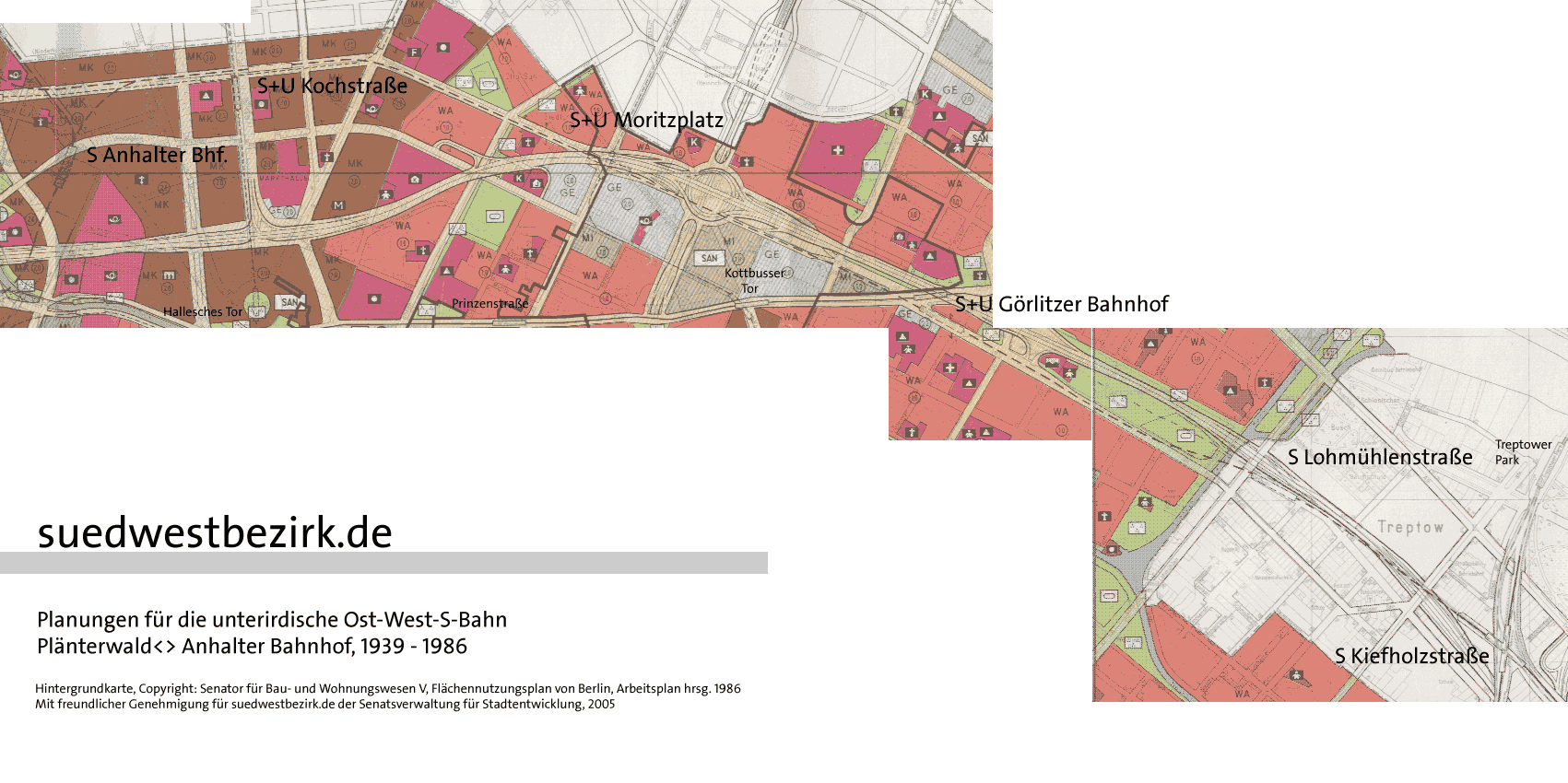
The East-West S-Bahn was the name given to a railway line designed in the 1930s as part of Germania planning between the now defunct Berlin terminal stations Anhalter and Görlitzer Bahnhof . The double-track tunnel line was intended to serve exclusively the S-Bahn traffic and, in extension with the Wannsee and Görlitzer Bahn, connect the south-west and south-east of the capital. A realization of the project was pursued on the West Berlin side until 1985 after the end of the Second World War .
Route description of the planning from 1938

The S-Bahn line was to unthread from the north-south S-Bahn at the Anhalter Bahnhof and, after crossing under the intersection of Stresemann and the corner of Anhalter Strasse, the Deutschlandhaus and the Prinz-Albrecht-Palais , which was destroyed in the Second World War, onto the course of Kochstrasse pan. On Friedrichstrasse , behind which Kochstrasse now turns into Rudi-Dutschke-Strasse, a transfer option was provided to the existing Kochstrasse underground station on line C (today: U6). Another station was planned at the corner of Lindenstrasse . Subsequently, the web should the Oranienstraße pivot and on moritzplatz , below the same place , the line D (now U8) intersect. The next train station was planned to be on the corner of Skalitzer Straße and would have made it possible to change to the existing Görlitzer Bahnhof underground station on line B (today: U1). The station should be named Skalitzer Straße to avoid confusion with the following station . A tunnel station at Görlitzer Bahnhof was planned at the level of Glogauer Strasse . The terminus of the same name should be closed. At the Görlitz freight station, the route should come to light, immediately cross the Landwehr Canal and cross under the Ringbahn . In the further course of the route, the total of around six kilometers should finally flow into the existing suburban tracks of the Görlitzer Bahn, which had been threaded out by the Ringbahn.
history

The first plans for a tunnel line along the Oranienstrasse and Görlitzer Bahn were made shortly after the first Berlin underground lines went into operation in 1902. A connection planned as line 5 should come from the Landwehr Canal below Wiener Strasse , i.e. parallel to the Görlitzer Bahn, and further on run along Oranienstrasse to Moritzplatz. Subsequently, a route was planned below the Kommandantenstrasse turning right to the Hausvogteiplatz underground station and on towards Moabit . During the construction of the Moritzplatz underground station, a short shell was built as a preliminary work for this route under the platform of the U8 underground line.
A change in planning came about when Ernst Reuter was appointed to the City Councilor for Transport in October 1926. Reuter revised the local transport plans and in January 1929 presented a memorandum on the future Berlin rapid transit network . Among other things, these plans now envisaged an underground S-Bahn line from Görlitzer Bahnhof via Friedrichstraße station to Lehrter Bahnhof . The preliminary construction work at Moritzplatz would have been used for the S-Bahn if these plans had been implemented.
When planning the redesign of Berlin's railway systems in the course of Germania planning, the Deutsche Reichsbahn took up the plans again. The background to this was the planned electrification of the Görlitz Railway to Königs Wusterhausen . However, the Stadtbahn and Ringbahn should not be permanently occupied with the additional trains. The western end point was not yet fixed. The city of Berlin wanted the route not to use both Leipziger Strasse and Unter den Linden , as they had their own subway plans in this regard. In talks between the Berlin Mayor Lippert and the Presidents of the Reichsbahndirektion and Reichsbahnbaudirektion Berlin , Marx and Pückel, on February 28, 1938, both sides agreed on a compromise regarding the future design of the S-Bahn and U-Bahn network. The east-west S-Bahn was to thread into the Potsdamer Platz or Anhalter Bahnhof stations from the south. In the further course, the trains should go to the Nordring or directly to Tegel . For its part, the city refrained from building subways in Saarlandstrasse (today: Stresemannstrasse) and building a subway to Siemensstadt . In return, the city was allowed to run an underground line through the north-south axis. A conversion of the Potsdamer Platz underground station on underground line A (today: U2) was also planned for the construction.
By order of the railway department of the Reich Ministry of Transport on April 2, 1938, the line was now to be introduced into the Anhalter Bahnhof from the north . The changes to the plan meant that a section of the tunnel at the Anhalter Bahnhof had to be demolished in order to enable the new route to be leveled. Originally, a sweeping system was to be built behind the Anhalter Bahnhof to the north, which is why the station was laid out with four tracks, similar to the north station . This has been corrected, the two inner tracks should now serve the north-south S-Bahn, while the two outer platform edges should be used by the new east-west S-Bahn. Nevertheless, the outer track 4 was to be used temporarily by the north-south S-Bahn, whereas no rails were laid for track 1, although a platform edge was laid out. After the BVG took over the management of the S-Bahn, rails were laid in track 1. The subsequent overpass over the second line means that track 1 can only be used bluntly from the south, which occasionally occurs during construction work. The directional operation of the trains in the direction of Wannsee and Lichterfelde Ost could only be started south of the Anhalter Bahnhof due to the plan changes. The train group K, which should serve the route according to the planning status of 1939, would come after the completion of the facilities from Königs Wusterhausen through the tunnel to Anhalter Bahnhof and from there on as long-distance S-Bahn or "banker train" only with a stop in the planned Drive through the Hornstrasse station to Zehlendorf .
No further preliminary construction work was carried out. The preliminary construction work in the Moritzplatz underground station was used as an air raid shelter during World War II .
After the end of the war, the plans for the tunnel section remained in the land use plans of the West Berlin Senate, but they have been adapted to the current circumstances in the current years. After the long-distance train station was closed in June 1951 , the stations at Skalitzer Strasse and Görlitzer Bahnhof were combined to form one station at Görlitzer Bahnhof south of the Skalitzer Strasse intersection. The planned train station at the Lindenstrasse intersection also disappeared. In addition to the transition to the U6, a transition to the planned U3 line was also planned on Kochstrasse . However, after the course of this line was swiveled to the parallel Leipziger Straße , this project became superfluous.
.png)
.png)
The western end of the line should also be extended by a tunnel to Potsdamer Platz , so that the trains coming from the Görlitz station could have been directed to both the southern and northern suburban lines.
A new Lohmühlenstrasse station was planned from 1965 to the east of the Landwehr Canal and thus on East Berlin territory. The construction of this station would have meant that the actual tunnel would be around 500 meters longer and would not come to light until Treptow . The Kiefholzstrasse S-Bahn station also only appeared in the zoning plans from 1965 onwards. One noticeable change was that when the station or the line went into operation, the connecting curve between the adjacent Treptower Park and Plänterwald stations, i.e. the track connection between the Ringbahn and Görlitzer Bahn, would have been omitted.
The plans of the West Berlin Senate never had a special priority, as it became apparent, especially after the building of the Wall in August 1961 and the subsequent boycott of the S-Bahn, that the S-Bahn would have no future. After the Reichsbahn strike in September 1980 and the associated closure of almost all West Berlin S-Bahn lines, the tunnel line was de facto put on hold; De jure, this took place with the creation of a new zoning plan in 1985.
Web links
- Andreas Jüttemann: The underground east-west S-Bahn through Kreuzberg. In: www.stadtschnellbahn-berlin.de. October 26, 2008. Retrieved October 27, 2008 .
- Andreas Jüttemann: The planned underground east-west S-Bahn. In: BahnInfo.de. Retrieved May 12, 2010 .
- Course of the east-west S-Bahn in the FNP 1965. (GIF) In: BahnInfo.de. Retrieved May 12, 2010 .
Individual evidence
- ^ A b Bernd Kuhlmann: Railway megalomania in Berlin. The plans from 1933 to 1945 and their implementation . 2nd Edition. Verlag GVE, Berlin 2008, ISBN 3-89218-093-8 , p. 68-69 .
- ↑ Wolfgang Kiebert: The electrical operation on the Berlin S-Bahn. Volume 3: Ten Dramatic Years - 1937 to 1946 . VBN Verlag Bernd Neddermeyer, Berlin 2013, ISBN 978-3-933254-20-7 , p. 45-55 .
- ↑ a b c d e f Andreas Jüttemann: The underground east-west S-Bahn through Kreuzberg. In: www.stadtschnellbahn-berlin.de. October 26, 2008, accessed February 1, 2017 .
- ↑ Wolfgang Kiebert: The electrical operation on the Berlin S-Bahn. Volume 3: Ten Dramatic Years - 1937 to 1946 . VBN Verlag Bernd Neddermeyer, Berlin 2013, ISBN 978-3-933254-20-7 , p. 21-28 .