Ouderkerkerplas
| Ouderkerkerplas | ||
|---|---|---|

|
||
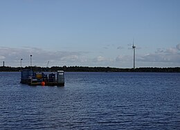
| Jetty on the north bank of the Ouderkerkerplas, 2009 | ||
| Geographical location | Ouderkerk aan de Amstel , Netherlands | |
| Drain | Bullewijk | |
| Location close to the shore | Amsterdam | |
| Data | ||
| Coordinates | 52 ° 17 '21 " N , 4 ° 55' 44" E | |
|
|
||
| Depth below sea level | -4 m NAP | |
| surface | 75 ha | |
| Maximum depth | 45 m | |
The Ouderkerkerplas is a quarry pond in the Dutch municipality of Ouder-Amstel , southeast of the village of Ouderkerk aan de Amstel and southwest of the Amsterdam district of Zuidoost . To the east, the Rijksweg A2 , to the south of the Rijksweg A9, borders the 75 hectare body of water, which is surrounded by a local recreation and nature reserve of about the same size .
description
The lake was created in the 1960s in what was then the Holendrecht and Bullewijker polders to extract the sand that was needed for the construction of the Rijksweg A9 motorway. First, a more than ten meter thick layer of bog soil and clay had to be removed, then sand was extracted to a depth of 45 meters. Later the water was used as a landfill for concrete waste. The original plan to fill a large part of the lake with building rubble for the route of another motorway junction was abandoned under pressure from the municipality of Ouder-Amstel.
Today the lake is part of the local recreation area Groengebied Amstelland , a joint project of the province of North Holland and the municipalities of Amstelveen , Amsterdam, Diemen and Ouder-Amstel. The Ouderkerkerplas is used for swimming, surfing and diving. On the shore, next to the beach and the Ouderkerkerplas water sports club (WVOP), there are numerous footpaths and bike paths as well as a riding path, barbecue, picnic and playgrounds. Every year around 500,000 people looking for relaxation visit the water.
In addition, the water is the habitat of numerous bird species, including the black godwit , sand martin , gadfly , whistling , tufted and shoveler , which breed here or settle here to hibernate. Since salt water flows from the North Sea, about 30 km away, into the relatively deep groundwater lake, a closed ice cover rarely forms on the brackish water in winter . Outside the reed zone , pechnelks , the overlooked orchid and rattle pots grow, among other things .
The water level of the lake is kept at four meters below the Amsterdam level (NAP) by pumping stations . In the event of a flood , the lake can be flooded by 60 cm by 3.40 meters below NAP via the Bullewijk river, which is normally used to drain the lake. The additional capacity of the lake is about ½ million cubic meters of water. The adjacent polders can also absorb roughly the same amount of water.
De Amstelvogel wind turbine
The De Amstelvogel wind turbine , which can be seen from afar, has been in operation on the southeastern bank of the Ouderkerkerplas since November 5, 2005 . Technical specifications:
- Operator: Coöperatie De Windvogel
- Type: Enercon E-70
- Electrical output: 2000 kW nominal output
- Calculated annual yield: 4,091,175 kWh
- Actual annual yield: 4,190,214 kWh
- Rotor diameter: 71 m
- Hub height: 85 m
Cold recovery
In 2009 and 2010, the energy company Nuon installed a cooling system for air conditioning in office buildings in Amsterdam-Zuidoost, about 15 meters below the surface of the water . The plant has an output of 60 MW.
Web links
- Groengebied Amstelland: Ouderkerkerplas (Dutch)
- Watersportvereniging Ouderkerkerplas (Dutch)
Individual evidence
- ↑ Jan Maarten Pekelharing: Ouderkerkerplas . As of May 31, 2011.
- ↑ Groengebied Amstelland: Ouderkerkerplas ( Memento of the original from March 4, 2016 in the Internet Archive ) Info: The archive link was inserted automatically and has not yet been checked. Please check the original and archive link according to the instructions and then remove this notice. . As of May 31, 2011.
- ↑ Mogelijkheden calamiteitenberging gebied Ouderkerkerplas ( Memento of the original from December 23, 2015 in the Internet Archive ) Info: The archive link was inserted automatically and has not yet been checked. Please check the original and archive link according to the instructions and then remove this notice. . As of May 31, 2011.
- ^ Coöperatie De Windvogel: De Amstelvogel . As of May 31, 2011.
- ↑ Groengebied Amstelland: Koudewinning Zuidoost / Ouderkerkerplas ( Memento of the original from March 4, 2016 in the Internet Archive ) Info: The archive link was inserted automatically and has not yet been checked. Please check the original and archive link according to the instructions and then remove this notice. . As of May 31, 2011.
- ↑ Nuon : Koude Centrale Amsterdam Zuidoost (animation of the operator on YouTube ). As of May 31, 2011.


