Pülswerda
|
Pülswerda
City of Arzberg
Coordinates: 51 ° 31 ′ 34 ″ N , 13 ° 4 ′ 20 ″ E
|
|
|---|---|
| Height : | 84 m above sea level NN |
| Residents : | 165 |
| Postal code : | 04886 |
| Area code : | 034222 |
|
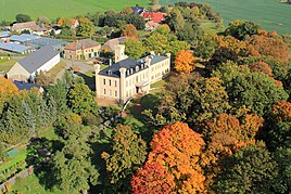
Pülswerda castle with park
|
|
Pülswerda is a district of the municipality of Arzberg in the district of North Saxony in Saxony .
location
Pülswerda is located opposite the village of Kunzwerda on the Elbe bend, southeast of the city of Torgau . The place can be reached via county road 8912.
history
Around 1368, the developing village of Pulczwerd was described as a single estate with an estate district and estate settlement of 306 hectares of land in an estate block corridor. The name developed over Pulßwerda a field and meadow marrow . From 1791 to 1821 the estate settlement with other houses in Pülswerda was written as it is today. In 1818 165 people lived in the village and in 1895 there were still 120. The official authority was in Torgau in 1378, then in Mühlberg / Elbe in 1696 and in Torgau from 1880 to 2012.


