Stand up
|
Stand up
community Arzberg
Coordinates: 51 ° 29 ′ 37 " N , 13 ° 10 ′ 55" E
|
|
|---|---|
| Height : | 88 m above sea level NN |
| Residents : | 266 (1964) |
| Postal code : | 04886 |
| Area code : | 034222 |
|
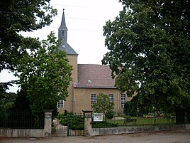
Village church
|
|
Stehla is a district of the municipality of Arzberg in the district of North Saxony in Saxony .
location
The southern border of the district of Stehla forms the Saxon- Brandenburg border. It is also located on the eastern Elbe dykes. The national road 25 runs through the district, according Arzberg and on. To the west, across the Elbe, lies Belgern and can be reached by ferry .
history
The line village with a corridor on 492 hectares was first mentioned as a stele in 1235 . 1248 a Wilhelmus scuthetus de stele is attested. It was called Stehla as early as 1590 . At that time ten people lived in the village, in 1818 there were 92, 1910 179, 1950 401 and 1964 266. The parish worked together with the parish Altbelgern . In 1314 the former settlement officially belonged to Torgau , then to Mühlberg / Elbe and Liebenwerda , before it belonged again to Torgau in 1952.
Culture and sights
→ see also: List of cultural monuments in Stehla

