
Pajęczno
| Pajęczno | |||
|---|---|---|---|

|
|
||
| Basic data | |||
| State : | Poland | ||
| Voivodeship : | Łódź | ||
| Powiat : | Pajęczno | ||
| Area : | 20.21 km² | ||
| Geographic location : | 51 ° 9 ′ N , 19 ° 0 ′ E | ||
| Residents : | 6705 (June 30, 2019) |
||
| Postal code : | 98-330 | ||
| Telephone code : | (+48) 34 | ||
| License plate : | EPJ | ||
| Economy and Transport | |||
| Street : | Radomsko - Wieluń | ||
| Next international airport : | Katowice | ||
| Gmina | |||
| Gminatype: | Urban and rural municipality | ||
| Gmina structure: | 19 school authorities | ||
| Surface: | 113.00 km² | ||
| Residents: | 11,562 (Jun. 30, 2019) |
||
| Population density : | 102 inhabitants / km² | ||
| Community number ( GUS ): | 1009043 | ||
| Administration (as of 2007) | |||
| Mayor : | Dariusz Tokarski | ||
| Address: | ul. Parkowa 8/12 98-330 Pajęczno |
||
| Website : | www.pajeczno.pl | ||

Pajęczno [ pa'jɛntʃnɔ ] ( German 1940 Peinstett , 1940–1943 Pfeilstett , 1943–1945 Pfeilstädt ) is a city in Poland in the Łódź Voivodeship .
history
In 1140, on the trade route from Russia to Silesia, a settlement called Pageuchno was first mentioned on the site of today's Pajęczno. The town received the town charter in 1265 by Leszek Czarny . During the third partition of Poland , the place became part of Prussia in 1795 . With the formation of the Duchy of Warsaw in 1807, he became part of the same and eight years later of the newly established Congress Poland . In 1810, on September 4th, a fire broke out, through which parts of the city and also important documents fell victim to the flames. The town lost its town charter in 1870 when Tsar Alexander II reduced the number of towns on Polish territory. After the end of the First World War , the place came to the Second Republic of Poland . During the attack on Poland , the city was occupied by the Wehrmacht . After the end of the Second World War in 1945, the city became part of Poland again and in 1956 the seat of its own powiat . Two years later, the city received city rights again. During an administrative reform, the place lost the Powiat seat in 1975 and became part of the newly formed Częstochowa Voivodeship . After another administrative reform, Pajęczno was again the seat of the powiat and part of the Łódź Voivodeship .
Population development
| year | 1793 | 1820 | 1850 | 1880 | 1900 | 1908 | 1921 | 1935 | 1971 | 2000 | 2007 |
|---|---|---|---|---|---|---|---|---|---|---|---|
| population | 643 | 1,077 | 1,253 | 2,057 | 2,895 | 1,756 | 2,609 | 3,500 | 4,000 | 6,731 | 6,672 |
In 1793 there were 130 houses in the city, in 1820 there were 176. In 1880 there were 195 houses.
local community
In addition to the town of Pajęczno, the urban and rural community also includes 19 districts with a Schulzenamt :
- Czerkiesy
- Dylów A-Tuszyn
- Dylów Rządowy
- Dylów Szlachecki
- Janki
- Kurzna-Barany
- Lipina (1943–1945 Lindenau )
- Ładzin
- Łężce
- Makowiska (1943–1945 Markwiese )
- Niwiska Dolne
- Niwiska Górne (1943–1945 Grenzflur )
- Nowe Gajęcice
- Patrzyków
- Podmurowaniec
- Siedlec
- Stare Gajęcice
- Wręczyca
- Wydrzynów
Other localities in the municipality are Grabiec, Podładzin and Sierociniec.
Culture and sights
Buildings
- The baroque church from the 16th century with a picture of the Virgin Mary with the child from the 13th century
- Market square in the old town with houses from the 19th century and an approximately 500 year old linden tree

Church of Our Lady
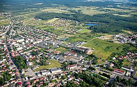
The northeast part of the city


traffic
The nearest station is the Biała Pajęczańska station on the Wyczerpy – Chorzew Siemkowice railway line , which is no longer used by passengers .
literature
- Pajęczno , in: Guy Miron (Ed.): The Yad Vashem encyclopedia of the ghettos during the Holocaust . Jerusalem: Yad Vashem, 2009 ISBN 978-965-308-345-5 , p. 572
Web links
Individual evidence
- ↑ a b population. Size and Structure by Territorial Division. As of June 30, 2019. Główny Urząd Statystyczny (GUS) (PDF files; 0.99 MiB), accessed December 24, 2019 .
- ↑ http://www.maerkische-heide.de/orte/kuschkow.htm
- ↑ Główny Urząd Statystyczny, "LUDNOŚĆ - STAN I STRUKTURA W PRZEKROJU TERYTORIALNYM", as of June 30, 2007 ( Memento of February 16, 2008 in the Internet Archive )
- ↑ http://maps.mapywig.org/m/German_maps/series/100K_KDR_Gross_and_Einheitsblaetter/Gb_106_Welun-Rosenberg_O.S.-Tschenstochau_XI.1944_APP_Sygn._M.100-xxxx.jpg
- ↑ http://maps.mapywig.org/m/German_maps/series/100K_KDR_Gross_and_Einheitsblaetter/Gb_106_Welun-Rosenberg_O.S.-Tschenstochau_XI.1944_APP_Sygn._M.100-xxxx.jpg
- ↑ http://maps.mapywig.org/m/German_maps/series/100K_KDR_Gross_and_Einheitsblaetter/Gb_106_Welun-Rosenberg_O.S.-Tschenstochau_XI.1944_APP_Sygn._M.100-xxxx.jpg