Łódź Voivodeship
|
|||
| map | |||
|---|---|---|---|
| Coat of arms and logo | |||
| Basic data | |||
| Capital : | Łódź | ||
| Voivode : | Jolanta Chełmińska | ||
| Voivodeship Marshal : | Witold Stępień | ||
| Biggest town: | Łódź | ||
| ISO 3166-2 : | PL-10 | ||
| Residents : | 2,476,315 (Dec. 31, 2017) | ||
| Population density : | 141 inhabitants per km² | ||
| geography | |||
| Area : | 18,219 km² | ||
| - of which country: | ? km² | ||
| - of which water: | ? km² | ||
| Expansion: | North-South: up to 158 km West-East: up to 163 km |
||
| The highest point: | ? m | ||
| Deepest point: | ? m | ||
| Landscape structure | |||
| Forests: | 20.8% | ||
| Waters: | ? % | ||
| Agriculture: | 60.7% | ||
| Other: | ? % | ||
| Administrative division | |||
| Independent cities : | 3 | ||
| Counties : | 21st | ||
| - Municipalities : | 177 | ||
The Łódź Voivodeship (Polish: województwo łódzkie ) is one of the 16 voivodships that make up the Republic of Poland . It covers the area in central Poland around the eponymous city Łódź ( Lodsch ) and has a large share of the historical region of Greater Poland . It emerged in 1999 in the course of the Polish administrative reform from the Sieradz , Piotrków and Łódź Voivodeships and parts of Skierniewice , Płock and Częstochowa .
coat of arms
Description : In red with two gold flanks at the base of the shield, a gold -rimmed, black - armored , gold-billed, silver-tongued black eagle with gold majuscule -R; In the upper right flank a black-armored, red-tongued red lion at the gap together with a left-facing, gold-armored, black-armored, silver-tongued silver eagle under a gold crown ; at the other gap in gold now the lion looking to the left and the eagle under the common crown is gold-edged, armored in black with a silver tongue and black.
Administrative division
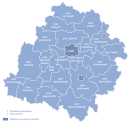
The Łódź Voivodeship is divided into 21 powiats , with two other cities remaining in addition to the provincial capital Łódź. They themselves do not belong to the districts named after them. In total, the voivodeship has 18 urban , 135 rural and 24 urban and rural municipalities .
One district cities
- Łódź (690.422)
- Piotrków Trybunalski (74,312)
- Skierniewice (48,308)
The number of inhabitants on December 31, 2017 in brackets.
Counties
|
The number of inhabitants on December 31, 2017 in brackets.
population
64.7 percent of the inhabitants of the Łódź Voivodeship live in cities. On December 31, 2004, 52.3 percent of the population were female, the proportion of women in the cities with a ratio of 114 to 100 was higher than in the villages with 101 women for 100 men. The population is predicted to decrease by over 150,000 by 2020 (as of 2004). The proportion of young residents will decrease, while the proportion of retirees will increase. In 2004, 22,473 births and 30,463 deaths were registered. The life expectancy for a newborn male child in 2003 was 68.96 years, for a female 78.06. These values were the lowest for the whole of Poland, where life expectancy averaged 70.52 and 78.9 years, respectively.
geography
Biggest cities
| city | Powiat | Resident December 31, 2017 |
|---|---|---|
|
|
circular | 690.422 |
|
|
circular | 74,312 |
|
|
Pabianice | 65,823 |
|
|
Tomaszów Mazowiecki | 63,238 |
|
|
Bełchatów | 57,964 |
|
|
Zgierz | 56,690 |
|
|
circular | 48,308 |
|
|
Radomsko | 46,409 |
|
|
Kutno | 44,513 |
|
|
Sieradz | 44,513 |
|
|
Zduńska Wola | 42,374 |
|
|
Łowicz | 28,704 |
|
|
Wieluń | 22,794 |
Rivers
economy
In comparison with the gross domestic product of the European Union expressed in purchasing power standards , the voivodeship achieved an index of 64 in 2015 (EU-28 = 100). The unemployment rate in December 2009 was 11.6 percent, which corresponds to 128,100 people. In 2017 the unemployment rate (according to Eurostat definition) was 4.6%.
The most important economic and administrative locations in the region include Piotrków Trybunalski, Bełchatów, Radomsko, Kutno, Zgierz, Pabianice, Skierniewice and Łowicz.
With a value of 0.844, Łódź ranks 7th among the 16 Voivodeships of Poland in the Human Development Index .
Web links
Individual evidence
- ^ Result of the 2011 census, Główny Urząd Statystyczny: Wyniki Narodowego Spisu Powszechnego Ludności i Mieszkań 2011. Warsaw, March 2012. Online ( Memento from January 16, 2013 in the Internet Archive ) (PDF)
- ↑ a b c Główny Urząd Statystyczny, "LUDNOŚĆ - STAN I STRUKTURA W PRZEKROJU TERYTORIALNYM". (PDF, select year).
- ↑ The Łódź Voivodeship. ( Memento of December 16, 2010 in the Internet Archive ) on lodzkie.pl.
- ↑ Eurostat. Retrieved April 15, 2018 .
- ↑ Central Statistics Office of Poland (CIS): Bezrobotni oraz stopa bezrobocia wg województw, grudzień 2009. ( Memento of April 2, 2015 in the Internet Archive ) February 3, 2010.
- ↑ Unemployment rate, by NUTS 2 regions. Retrieved November 5, 2018 .
- ↑ Information about the region . regiony.gov.pl. Retrieved September 16, 2013.
- ^ Sub-national HDI - Area Database - Global Data Lab. Retrieved August 12, 2018 .
Coordinates: 51 ° 37 ′ N , 19 ° 25 ′ E


