Parsęta
|
Parsęta Persante |
||
|
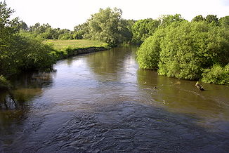
The Parsęta near Karlino (Körlin) |
||
| Data | ||
| location | West Pomeranian Voivodeship , Poland | |
| River system | Parsęta | |
| River basin district | Or | |
| source | near Parsęcko ( Szczecinek municipality ) 53 ° 43 ′ 23 ″ N , 16 ° 34 ′ 12 ″ E |
|
| Source height | 137 m | |
| muzzle | at Kołobrzeg in the Baltic Sea Coordinates: 54 ° 11 ′ 14 ″ N , 15 ° 33 ′ 10 ″ E 54 ° 11 ′ 14 ″ N , 15 ° 33 ′ 10 ″ E
|
|
| length | 143 km | |
| Catchment area | 3145 km² | |
| Discharge at the mouth of the A Eo : 3145 km² |
MQ Mq |
29.4 m³ / s 9.3 l / (s km²) |
| Left tributaries | Gęsia (Gänsebach) , Dębnica (Damitz) , Mogilica (Muglitz) , Pokrzywnica (Krummes Wasser) | |
| Right tributaries | Perznica (Pirnitz) , Liśnica (Leitznitz) , Radew (Radüe) | |
| Medium-sized cities | Białogard , Kołobrzeg | |
| Small towns | Karlino | |
The Parsęta ( [parˈsɛnta] ; German Persante ) is a 143 km, according to other sources 127.1 km long river in the Polish West Pomeranian Voivodeship (formerly Hinterpommern ).
course
The river rises at a height of 137 meters above sea level at Parsęcko ( Persanzig ), flows strongly meandering north and flows into the Baltic Sea at Kolberg ( Kołobrzeg ) .
The course of the river is varied: while it feeds a wetland at the source, it is then contained in a ditch. Due to the catchment area of 3,145 km² and a relatively large gradient, it has the character of a wild water stream in the further upper reaches. At Belgard ( Białogard ) it is diked, at the village of Rościno ( Rostin ) there is a hydroelectric power station and a weir . Later it flows through alluvial forests , meadows and peat bogs and is only dammed with a weir except in the city of Kolberg. There, the flow in the main run and splits Kanał Drzewny (wood channel), whose flow through a contactor is controlled, and which flows into the fishing port. The wooden dams or bank reinforcements of the Persante from the time before the Second World War are often flooded and only left in remnants, the course of the river is thus subject to its natural dynamics again.
While the upper course is repeatedly blocked by tree obstacles, the Persante from Körlin ( Karlino ) is suitable for canoeing , there are designated resting places for water hikers .
According to linguists, the name of the river is to be interpreted in Prussian : "perses" is a swampy place in the forest or a place in the ice that does not freeze. The German name Persante can therefore be translated as "swamp river". It is considered the western border of the former Baltic language area.
literature
- Ludwig Wilhelm Brüggemann : Detailed description of the current state of the Königl. Prussian Duchy of Vor and Hinter Pomerania . Part II, Volume 1, Stettin 1784, pp. IX-X.
- Leopold von Zedlitz-Neukirch : New hydrographic lexicon for the German states . Halle 1833, p. 302.
- Wilhelm Reinhold Brauer: Baltic-Prussian settlements west of the Vistula. Nicolaus-Copernicus-Verlag, Münster 1988, ISBN 3-924238-12-X ( sources and representations on the history of West Prussia 24).
- Wolfgang P. Schmid : Linguisticæ scientiæ collectanea. Selected Writings. Edited by Joachim Becker on the occasion of his 65th birthday. De Gruyter, Berlin a. a. 1994, ISBN 3-11-013440-3 , p. 274, link to the text passage .
Web links
- Map with the course of the river and information on water hiking (Polish); Retrieved June 7, 2015
- Parsęta Community Association blog (Polish); Retrieved June 7, 2015
- Route description and tour report for water hiking
- Official route description for water sports (PDF; 5.7 MB) - description in German from page 18
Individual evidence
- ↑ Obszary dorzeczy - Ramowa Dyrektywa Woda ( Memento of the original from June 2, 2015 in the Internet Archive ) Info: The archive link was inserted automatically and has not yet been checked. Please check the original and archive link according to the instructions and then remove this notice. , accessed April 2, 2015
- ↑ a b HELCOM: PL.pdf Sea Trout and Salmon Populations and Rivers in Poland - HELCOM assessment of salmon (Salmo salar) and sea trout (Salmo trutta) populations and habitats in rivers flowing to the Baltic Sea ( page no longer available , search in web archives ) Info: The link was automatically marked as defective. Please check the link according to the instructions and then remove this notice. . Balt. Sea Environ. Proc. No. 126B. Helsinki 2011
- ^ Regional water management in the Szczecin region
- ↑ Position of the inflow of Kanał Drzewny (wooden canal)
- ↑ Brauer, p. 93 ff.


