Karlino
| Karlino | ||
|---|---|---|

|
|
|
| Basic data | ||
| State : | Poland | |
| Voivodeship : | West Pomerania | |
| Powiat : | Białogard | |
| Gmina : | Karlino | |
| Area : | 9.00 km² | |
| Geographic location : | 54 ° 2 ' N , 15 ° 53' E | |
| Height : | 8 m npm | |
| Residents : | 5950 () | |
| Postal code : | 78-230 | |
| Telephone code : | (+48) 94 | |
| License plate : | ZBI | |
| Economy and Transport | ||
| Street : | DK 6 Kołbaskowo ↔ Pruszcz Gdański | |
| Ext. 163 Kołobrzeg ↔ Wałcz | ||
| Rail route : | Szczecinek – Kołobrzeg railway line | |
| Next international airport : | Szczecin-Goleniów | |
| administration | ||
| Address: | Pl.Jana Pawła II 6 78-230 Karlino |
|
| Website : | www.karlino.pl | |
Karlino (German Körlin an der Persante ) is a town in the powiat Białogardzki ( Belgarder Kreis ) of the Polish West Pomeranian Voivodeship . It is the capital of the urban and rural community of Gmina Karlino .
The town of Karlino should not be confused with the town of Korlino (German: Körlin , in the former Schlawe district).
Geographical location
The city is located in Western Pomerania at the confluence of the Persante ( Parsęta ) and Radüe ( Radew ), about 27 kilometers southwest of the city of Köslin and 110 kilometers northeast of the city of Szczecin .
This is where Landesstraße 6 ( Stettin - Danzig , former German Reichsstraße 2 , today's Europastraße 28 ) and the Voivodship Road 163 ( Kołobrzeg ( Kolberg ) - Wałcz ( Deutsch Krone ), former Reichsstraße 124 ) cross, and there is a connection to the Szczecinek– Kołobrzeg .
history

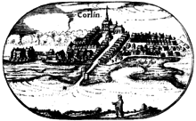
Körlin on the Lubin map from 1618.
|
Körlin has long benefited from its once favorable traffic situation. Coin finds from the Iron Age (around 900 BC) suggest that there was already a trading post at the intersection of the military route to Danzig and the salt route to the south during this period.
middle Ages
In a description of the diocese of Cammin from 1240 there is a reference to the village of Körlin for the first time. A document from 1299 speaks of the "civis in Corlin". In 1372, Körlin was raised to one of the residences of the diocese of Cammin by Bishop Philipp von Rehberg , and a protective castle was built with financial help from the city of Stolp . In 1385 received the Körlin by the Bishop Lubeck city rights . When there were disputes between the Pomeranian Duke Bogislaw VIII and the Bishops of Cammin in 1409 , the Duke attacked Koerlin and completely destroyed it except for the episcopal castle.
Early modern age
After the introduction of the Reformation in Pomerania, the diocese of Cammin lost its political independence in 1556 and came under the rule of the Pomeranian dukes. The now Protestant bishops transformed the Körlin Castle in the following years into a palace in the Renaissance style and ensured the town's economic boom. Due to special privileges, an efficient brewing industry developed from 1594 and a sawmill was established. During the Thirty Years War , Körlin was sacked by the imperial troops. In 1668 the city became the Brandenburg state domain . On Holy Saturday 1685 a fire broke out, which cremated the city with the exception of the church and the castle. A second fire destroyed the Körlin suburb in 1765. During the Seven Years' War , Russian troops raided the city and destroyed the episcopal castle, which was not rebuilt afterwards.
19th century
When the Napoleonic army besieged Kolberg in February 1807 , Körlin was designated as the French main director's camp. When the soldiers were stationed, an epidemic of dysentery broke out, killing a third of the population.
Even after the Prussian administrative reorganization of 1818, Körlin initially remained in the unchanged administrative area " Camminer Fürstenthum ". In 1849 the road from Kolberg to Neustettin was rebuilt into a modern highway, and this gave Körlin a convenient north-south connection. However, it was not possible to connect the city to the economically important railway line Stettin – Köslin, which was relocated six kilometers south through Belgard. Körlin was only connected to the rail network in 1859 by the Belgard – Kolberg branch line. Modern industry only arrived in the last quarter of the 19th century. Several new mills, including a special mill for grinding oak bark, were set up, a large sawmill and machine factory were built, and a large granary was built on the site of the former bishop's castle. At this time, Körlin belonged to the newly formed Kolberg-Körlin district in 1872 and had around 3,100 inhabitants.
20th century
In 1905 a new building for the district court was inaugurated in the city, and two years later a new town hall had to be built because the previous one had fallen victim to a fire. After the First World War , there was an increase in population due to former residents of the eastern provinces lost by the Versailles Treaty . As a result, the city expanded to the north.
Shortly before the start of the Second World War , a sports center and a youth hostel were built. Towards the end of the war, on March 3, 1945, the city was ordered to evacuate the civilian population. The call came too late, however, because a day later Körlin was captured by the Soviet troops . Soon afterwards the city was placed under Polish administration together with the whole of Western Pomerania . The residents were expelled from Koerlin in the following months and replaced by Poles.
Demographics
| year | Number of inhabitants |
Remarks |
|---|---|---|
| 1740 | 566 | |
| 1782 | 894 | including 32 Jews |
| 1791 | 898 | including 19 Jews |
| 1794 | 909 | including ten Jews |
| 1812 | 1,060 | including a Catholic and 21 Jews |
| 1816 | 1,225 | including ten Catholics and 55 Jews |
| 1831 | 1,745 | including six Catholics and 96 Jews |
| 1843 | 2,193 | including eleven Catholics and 95 Jews |
| 1852 | 2,633 | including 14 Catholics and 131 Jews |
| 1861 | 2.147 | including twelve Catholics and 148 Jews |
| 1875 | 3.157 | |
| 1880 | 3,301 | |
| 1890 | 3.128 | including 23 Catholics and 97 Jews |
| 1925 | 3,057 | including 2,954 Protestants, 20 Catholics and 22 Jews |
| 1933 | 3,365 | |
| 1939 | 3,429 |
sons and daughters of the town
- Christian Alwart (1624–1695), German music teacher and theologian
- Christian Gabriel Klingemann (1703–?), Military elector of Saxony
- Johann Ernst Benno (1777–1848), German writer, wrote historical novels on the history of Pomerania
- Albrecht von Schroeder (1833–1910), Prussian major general and commander of an infantry regiment
- Albert von Zingler (1836–1891), Prussian lieutenant general and commander of an infantry brigade
- Ernst Albert Fischer-Cörlin (1853–1932), German painter
- Gustav Boehmer (1881–1969), German lawyer and university professor
- Kurt Höck (1920–2008), German doctor and clinic director
literature
- Gustav Kratz : The cities of the province of Pomerania - outline of their history, mostly according to documents . Berlin 1965, pp. 67-70 ( online ).
- Heinrich Berghaus : Land book of the Duchy of Pomerania and the Principality of Rügen . Part III, Volume 1, Anklam 1867, pp. 162–168 ( online )
- Ludwig Wilhelm Brüggemann : Detailed description of the current state of the Royal Prussian Duchy of Western and Western Pomerania . Part II, Volume 2, Stettin 1784, pp. 518-525 ( online )
Web links
- City website (Polish, German, English)
- Körlin at the Kolberger Lande association
Footnotes
- ↑ Karlino at polskawliczbach.pl.
- ↑ a b c Christian Friedrich Wutstrack , Ed .: Short historical-geographical-statistical description of the royal Prussian duchy of Vor und Hinterpommern . Stettin 1793, p. 600.
- ↑ a b c d e f g Gustav Kratz : The cities of the province of Pomerania - outline of their history, mostly according to documents . Berlin 1965, p. 69 .
- ↑ a b c d e Michael Rademacher: German administrative history from the unification of the empire in 1871 to the reunification in 1990. kolberg.html # ew39kolkorli. (Online material for the dissertation, Osnabrück 2006).
- ^ City of Körlin in the Pommern information system.


