Phetchabun
|
เพชรบูรณ์ Phetchabun |
||
|---|---|---|
|
|
||
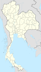
| Coordinates | 16 ° 25 ' N , 101 ° 9' E | |
| Basic data | ||
| Country | Thailand | |
| Phetchabun | ||
| ISO 3166-2 | TH-67 | |
| Residents | 22,468 (2012) | |
|
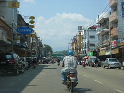
Street scene in Phetchabun
|
||
Phetchabun (Thai เพชรบูรณ์ , pronunciation: [ pʰétt͡ɕʰáʔbuːn ]) is a city ( เทศบาล เมือง เพชรบูรณ์ ) in the Thai province of Phetchabun . It is the “capital” of Phetchabun Province in the northern region of Thailand .
The city of Phetchabun has 22,468 inhabitants. (Last updated 2012)
etymology
The name is made up of เพชร ( phet ) "Diamond", from Sanskrit vajra , the thunderbolt of God Indra , and บูรณ์ ( bun ) from Sanskrit / Pali Purana , "full".
geography
Phetchabun lies at an altitude of 114 m. ü. M. and about 350 kilometers northeast of Bangkok . From the capital, Phetchabun can be reached via the expressways Route 1 (125 km) and then Route 21 (225 km). The city is located in the midst of a charming landscape in the extensive valley of the Mae Nam Pa Sak (Pa-Sak River). The valley has a north-south gradient. The fertile plain is used intensively for agriculture. In the north of the city is the Phetchabun Mountains whose highest peak reaches 1794 meters. The eastern and western sides of the valley are bordered by the wooded foothills of the Phetchabun Mountains.
climate
|
Monthly average temperatures and rainfall for Phetchabun
|
Economy and Importance
In the vicinity of the city there is mainly agriculture and cattle breeding:
Airport
- The Phetchabun Airport is located about 33 km north of the center, on the right side of the national road 21st
- The Pho Khun Pha Mueang military airport , with a runway of 1500 meters, is located in the Sadiang district, Mueang Phetchabun
Streets
- The Route 21 (National Road 21) crosses the city from south to north direction.
Attractions
In honor of His Majesty King Bhumibol Adulyadej and on the occasion of His Majesty's 84th birthday on December 5, 2011, the people of Phetchabun wanted to erect a monument to their king , which should also illustrate the stability of Buddhism in Phetchabun. A holy statue of Phra Buddha Maha Thammaracha (พระพุทธ รูป มหา ธรรมราชา) has always been venerated here. This statue is 18 inches high and 13 inches wide. In a construction period of only nine months, a bronze copy of this statue was inaugurated on September 27, 2011, with a height of 15.599 meters, a width of 11.984 meters and a weight of over 40 tons, on a 35 meter high base. The statue was named:
- Phra Buddha Maha Thammaracha Chalerm Phrakiat (พระพุทธ รูป มหา ธรรมราชา เฉลิมพระเกียรติ)
and stands in Phetchabura Buddhist Park on Route 21, about 4 km north of the city center, on the right-hand side.
There are various noteworthy Buddhist temples ( Wat ) in the city. For example the:
- Wat Thung Sadiang (วัด ทุ่ง สะ เดียง), at the 2006, Nai Mueang
- Wat Chang Phueak (วัด ช้างเผือก), at the 2006, Nai Mueang
- Wat Maha That (วัด มหาธาตุ), Nikorn Bamrung Rd.
- Wat Phu Khao Din (วัด ภูเขา ดิน), Phra Phutthabat Rd.
- Wat Phet Wararam (วัดเพชรว รา ราม), Thanon Thedsaban Pattana Rd.
- Wat Phra Kaeo (วัด พระ แก้ว), Petch Charoen Rd.
- Wat Trai Phum (วัด ไตรภูมิ), Phetcharat Alley. The holy statue of Phra Buddha Maha Thammaracha is kept here.
- Wat Pho Yen (วัด โพธิ์ เย็น), Lak Muang Rd.
- Wat Bot Chanaman (วัดโบสถ์ ชนะ มาร), Soi Sanam Chai 1
- Wat Pratu Dao (วัด ประตู ดาว), Pratu Dao Alley
If you turn off Route 21 into Burakarm Kovit Rd. (Road 2006) and follow it westwards, after about 9 km you will reach Ban Pa Lao. The village is on
- Huai-Pa-Daeng Reservoir
This serves as a water reservoir for agricultural use. On the east side of the lake a dam about 1200 meters long and 10 meters high with a crown height of about 163 m was built. ü. M. created. A widely ramified canal system has been laid between the dam and Route 21 . Water is pumped into the canal system via the dam via a pump house. This means that an agriculturally used area of around 64 km² can be supplied with water. A funnel-shaped standpipe was created to protect the dam from damage by flooding when the water level is high. Overflowing water flows into the Pa Sak in a channel named as Pa Daeng. The Huai-Pa-Daeng is a popular local recreation area.
Offering pure nature experiences:
- National Park Thung Salaeng Luang on the western side and
- Tat Mok and National Park
- Nam Nao National Park on the eastern side of Phetchabun.
The Nam Nao National Park is known for its stalactite caves . Large stalactites and stalagmites can be admired in the Tham-Pha-Hong cave . At the cave there is a lookout point that offers a beautiful view at sunset. The cave is 83 km northeast of Phetchabun. Follow route 21 44 km north to the town of Lom Sak , there take main road 12 east to kilometer stone 39, turn north, another 300 meters to the cave entrance.
Personalities
- Chakrit Buathong (born 1985), football player
- Pongpanot Naknayom (* 1979), football player
- Anan Surattanasin (* 1998), soccer player
Web links
- City map of Phetchabun (names in English and Thai). Retrieved October 18, 2019
Individual evidence
- ↑ Department of Provincial Administration : As of 2012 (in Thai)
- ↑ Patrick Lepetit: Nam Nao National Park . 2016. Retrieved October 19, 2019


