Pian di Scò
| Pian di Scò | |||
|---|---|---|---|

|
|||
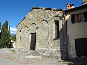
| Santa Maria a Scò | |||
| Country | Italy | ||
| region | Tuscany | ||
| province | Arezzo (AR) | ||
| local community | Castelfranco Piandiscò | ||
| Coordinates | 43 ° 39 ' N , 11 ° 33' E | ||
| height | 349 m slm | ||
| Residents | 1,955 (2001) | ||
| patron | Assunzione di Maria (August 15) | ||
| Telephone code | 055 | CAP | 52020 |
Pian di Scò is a hamlet in the town of Castelfranco Piandiscò in the province of Arezzo in the Region of Tuscany in Italy .
geography
The place extends over approx. 18 km² . It is located about 35 km northwest of Arezzo and 30 km southeast of Florence . The district of Matassino is located on the Arno .
Other districts include Faella , Menzano, Montalpero, San Miniato, Simonti and Vaggio.
The neighboring towns are Castelfranco di Sopra , Figline Valdarno ( FI ) and Reggello (FI).
history
Pian di Scò (main town)
Up to the end of the 18th century, the history of the place is linked to the Romanesque Pieve Santa Maria a Scò, built around the year 1000 . There are two theories about the origin of the name: the first derives the name from the nearby Arno tributary Resco , the second relates the name to Aesculus , the oak of Jupiter . Under the rule of the Republic of Florence, the parish joined the Lega di Castelfranco . After the Lega was dissolved in 1774 by Leopold II , Pian di Scò was incorporated into the neighboring municipality of Castelfranco. After the occupation of Tuscany by Napoleonic troops, the municipality became independent in 1809. In 1873 the Palazzo Comunale ( town hall ) was built.
Faella (district of Pian di Scò)
The town is named after the river of the same name, which flows through the town of Faella and flows into the Arno a few kilometers to the west. The river originally gave its name to two places: Faella for the lower part and Favilla for the higher part. In 1311 both parts were merged to form the municipality of Faella. With the reforms of Leopold II. Faella was incorporated into the neighboring municipality of Pian di Scò in 1773. During the retreat of the German soldiers, the place was almost completely destroyed at the end of the Second World War .
Matassino (district of Pian di Scò)
Matassino is the district of Pian di Scò, which lies directly on the Arno. It is also part of a total of three municipalities in two provinces: Figline Valdarno and Reggello in the metropolitan city of Florence and Castelfranco Piandiscò (Province of Arezzo).
Municipality of Pian di Scò
The municipality of Pian di Scò merged with Castelfranco di Sopra on January 1, 2014 to form the new municipality of Castelfranco Piandiscò . On December 31, 2013 it had 6526 inhabitants on an area of 18.42 km².
Attractions
- Palazzo Comunale (former town hall), built in 1873 according to plans by Emilio De Fabris .
- Pieve Santa Maria a Scò, first mentioned in 1008.
literature
- Emanuele Repetti: PIAN DI SCO 'nel Val d'Arno superiore. In: Dizionario Geografico Fisico Storico della Toscana (1833–1846). Online edition of the University of Siena (PDF, Italian)
- Touring Club Italiano : Toscana. Milan 2003, ISBN 978-88-365-2767-0 , p. 785.
Web links
Individual evidence
- ↑ a b Official website of the former municipality of Pian di Scò on the history of the place ( Memento of the original from December 6, 2009 in the Internet Archive ) Info: The archive link has been inserted automatically and has not yet been checked. Please check the original and archive link according to the instructions and then remove this notice. , accessed on January 2, 2010 (Italian)
- ↑ Official website of the former municipality of Pian di Scò on Pieve Santa Maria a Scò ( Memento of the original from November 20, 2008 in the Internet Archive ) Info: The archive link has been inserted automatically and has not yet been checked. Please check the original and archive link according to the instructions and then remove this notice. , accessed on January 2, 2010 (Italian)
