Prahova (river)
| Prahova | ||
|
The Prahova north of Sinaia |
||
| Data | ||
| location | Districts of Brașov , Prahova , Ialomița ( Romania ) | |
| River system | Danube | |
| Drain over | Ialomița → Danube → Black Sea | |
| source | for Predeal 45 ° 30 ′ 15 ″ N , 25 ° 35 ′ 8 ″ E |
|
| Source height | 1037 m | |
| muzzle | at Adâncata in the Ialomița coordinates: 44 ° 42 ′ 32 " N , 26 ° 28 ′ 47" E 44 ° 42 ′ 32 " N , 26 ° 28 ′ 47" E |
|
| Mouth height | 63 m | |
| Height difference | 974 m | |
| Bottom slope | 5.3 ‰ | |
| length | 183 km | |
| Catchment area | 3738 km² | |
| Drain |
MQ |
28 m³ / s |
| Left tributaries | Doftana , Teleajen , Cricovul Sărat | |
| Medium-sized cities | Câmpina | |
| Small towns | Predeal , Buşteni , Sinaia , Comarnic , Breaza | |
|
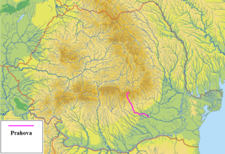
The Prahova in Romania |
||
The Prahova is a left tributary of the Ialomița in the south of Romania .
The 183 km long river has a catchment area of 3738 km². In the valley of the Prahova river are Azuga (in the upper valley of the river), Sinaia , Comarnic and Breaza .
The Prahova administrative district in the Wallachia region is named after the river.
Web links
Commons : Prahova - collection of images, videos and audio files

