
Printze
|
Printze Printse |
||
 |
||
| Data | ||
| Water code | CH : 169 | |
| location | Nendaz , Canton of Valais , Switzerland | |
| River system | Rhone | |
| Drain over | Rhone → Mediterranean | |
| source |
Firn on the northwest slope of Grand Mont Calme 46 ° 4 ′ 53 ″ N , 7 ° 21 ′ 29 ″ E |
|
| Source height | approx. 2890 m above sea level M. | |
| muzzle | at Aproz in the Rhône coordinates: 46 ° 12 '36 " N , 7 ° 19' 17" E ; CH1903: 590954 / 117637 46 ° 12 '36 " N , 7 ° 19' 17" O |
|
| Mouth height | 479 m above sea level M. | |
| Height difference | approx. 2411 m | |
| Bottom slope | approx. 16% | |
| length | 14.8 km | |
| Catchment area | 72.11 km² | |
| Discharge at the estuary A Eo gauge: 72.11 km² |
MQ Mq |
1.81 m³ / s 25.1 l / (s km²) |

The Printze (also called Printse ) is a mountain stream around 15 kilometers long in the canton of Valais in Switzerland . It rises above Lac de Cleuson from a firn on the northwest slope of Grand Mont Calme . Its confluence with the Rhône lies below Nendaz near Aproz . Most of the river flows through the Conthey district and only a little bit in the Sion district . Its course forms the region of the Val de Nendaz .
geography
The Printze has cut a deep notch valley with steep slopes into the landscape . Shortly before it enters the alluvial plain of the Rhône, the valley near the Cor settlement takes on the shape of a gorge . In its middle course, the Bissen (Suonen) Bisse Vieux , Bisse du Milieu and Bisse d'en Bas , originally also the Bisse de Saxon , branch off to the left . On the right, the tributaries of the still existing Bisse de Vex and Bisse de Baar are interrupted, only the Bisse de Salins is supplied with water. All three bites extend into the municipal area of Veysonnaz and Salins .
The flanking landscape is characterized by the slopes of the Dent de Nendaz ( 2463 m ) and Le Métailler ( 3212.9 m ), which descend to their valley .
The course of the Printze extends largely in the area of the municipality of Nendaz, but only touches the immediate settlement area in a few places because of the deep valley cut. This affects the settlement areas of Planchouet , Saclentse and Beuson as well as the Siviez ski station . In Beuson , the river is spanned by a larger road bridge, the street of which connects Sion with Nendaz.
Tributaries
and other small watercourses.
Sights and buildings
- Dam and water surface of the Lac de Cleuson
- Siviez
- Prarion landscape
- Beuson

The Bisse Vieux above Haute Nendaz

The Val de Nendaz above the Siviez ski station (view towards Sion)
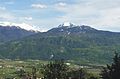
View over the Rhone valley to Dent de Nendaz with the Printze valley cut (left)


See also
literature
- Office fédéral de topographie : Carte Nationale de la Suisse 1: 25,000 . Sheet 1306 Sion (Wabern 2001)
- Office fédéral de topographie: Carte Nationale de la Suisse 1: 50,000 . Sheet 5003 Mont Blanc, Grand Combin (Wabern 1999)
Individual evidence
- ↑ a b Geoserver of the Swiss Federal Administration ( information )
- ↑ Hydrological Atlas of Switzerland of the Federal Office for the Environment FOEN, Table_13
- ↑ a b Modeled mean annual discharge. In: Topographical catchment areas of Swiss waters: sub-catchment areas 2 km². Retrieved August 20, 2017 .