Tarma Province
| Tarma Province | |||
|---|---|---|---|
 Location of the province in the Junín region |
|||
| Symbols | |||
|
|||
| Basic data | |||
| Country | Peru | ||
| region | Junín | ||
| Seat | Santa Ana de Tarma | ||
| surface | 2749 km² | ||
| Residents | 89,590 (2017) | ||
| density | 33 inhabitants per km² | ||
| ISO 3166-2 | PE-JUN | ||
| Website | www.munitarma.gob.pe (Spanish) | ||
| politics | |||
| Alcalde Provincial | Moisés Martín Tacuri García (2019-2022) |
||
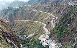
| View of the Carpapata hydroelectric power station and the Tarma – San Ramón road | |||
Coordinates: 11 ° 21 ′ S , 75 ° 41 ′ W
The province of Tarma is one of nine provinces in the Junín region in central Peru . The province has an area of 2749 km². The administrative seat is the city of Santa Ana de Tarma .
Geographical location
The province of Tarma is located in the Peruvian Central Cordillera , east of the upper reaches of the Río Mantaro and south of the Junín Lake . It extends over part of the catchment area of the Río Tarma , left source of the Río Chanchamayo . The province lies in a transition zone from the Andean highlands to the Amazonian lowlands. It borders in the north on the province of Junín , in the east on the province of Chanchamayo , in the south on the province of Jauja and in the west on the province of Yauli .
population
The province has a decreasing population development. In 1993 the population was 115,686. In 2007 it was 112,230, in 2017 89,590.
structure
The province of Tarma is divided into the following nine districts ( Distritos ). The Tarma district is the seat of the provincial administration.
| District | Administrative headquarters |
|---|---|
| Acobamba | Acobamba |
| Huaricolca | Huaricolca |
| Huasahuasi | Huasahuasi |
| La Unión | Leticia |
| Palca | Palca |
| Palcamayo | Palcamayo |
| San Pedro de Cajas | San Pedro de Cajas |
| Tapo | Tapo |
| Tarma | Santa Ana de Tarma |
Individual evidence
- ↑ a b Tarma, Province in Junín Region . www.citypopulation.de. Retrieved November 9, 2019.


