Colán district
| Colán district | |
|---|---|
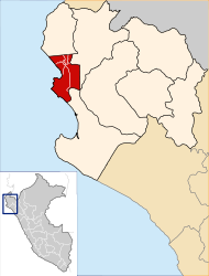
 The Colán District is located in the northwest of the Paita Province (marked in red) |
|
| Basic data | |
| Country | Peru |
| region | Piura |
| province | Paita |
| Seat | Pueblo Nuevo |
| surface | 123 km² |
| Residents | 15,608 (2017) |
| density | 127 inhabitants per km² |
| founding | October 8, 1840 |
| ISO 3166-2 | PE-PIU |
| Website | www.municolan.gob.pe (Spanish) |
| politics | |
| Alcaldesa district | Antolina Vivas Chunga (2019-2022) |
| Iglesia de San Lucas de Colán | |
Coordinates: 4 ° 54 ′ S , 81 ° 3 ′ W
The Colán district is located in the Paita Province of the Piura region in northwestern Peru . The district was founded on October 8, 1840. It has an area of 123 km². At the 2017 census, 15,608 people lived in the district. In 1993 the population was 11,661, in 2007 12,332. The administrative center is the 15 m high city of Pueblo Nuevo with 12,116 inhabitants (as of 2017). Pueblo Nuevo is located 21 km northeast of the provincial capital Paita .
Geographical location
The Colán district is located on the Pacific coast north of the provincial capital Paita. In the north the district is bounded by the Río Chira .
The Colán district borders the Vichayal district in the north, the Amotape , El Arenal and La Huaca districts in the east, and the Paita district in the south .
Individual evidence
- ↑ a b Peru: Piura - Provinces & Districts . www.citypopulation.de. Retrieved June 11, 2020.
