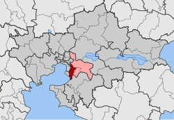
Pylea
|
Parish of Pylea Δημοτική Ενότητα Πυλαίας (Πυλαία) |
||
|---|---|---|
|
|
||
| Basic data | ||
| State : |
|
|
| Region : |
Central Macedonia
|
|
| Regional District : | Thessaloniki | |
| Municipality : | Pylea Chortiatis | |
| Geographic coordinates : | 40 ° 36 ′ N , 22 ° 59 ′ E | |
| Height above d. M .: | 90 m (average) |
|
| Area : | 24.634 km² | |
| Residents : | 34,625 (2011) | |
| Population density : | 1,405.6 inhabitants / km² | |
| Code No .: | 071202 | |
| Structure: |
1 municipality |
|
| Located in the municipality of Pylea-Chortiatis and in the regional district of Thessaloniki | ||
Pylea ( Greek Πυλαία ( f. Sg. ), Also Pylaia ) is an eastern suburb of Thessaloniki in the metropolitan area of Thessaloniki . Pylea has a coastline of 4.5 km on the bay of Thessaloniki or on the Thermaic Gulf and extends from the southwest (sea) to the northeast in the direction of the mountain Chortiatis .
In the Pylea area, the ancient settlement of Strepsa is mentioned in the writings of Thucydides (319 BC). Under Ottoman occupation, the settlement was named Kapoutzida, referring to the Turkish name for guards (who guarded the city of Thessaloniki). Under the name Kapoutzides (Καπουτζήδες) it was recognized as a rural community (kinotita) in 1918 , renamed Strefa (Στρέφα) in 1926 and finally Pylea in 1928, the Greek word pyli πύλη 'gate' (here meant the eastern gate to Thessaloniki) being the godfather for the name was. In 1982 Pylea was raised to a municipality (dimos) . This parish was merged in 2010 with Chortiatis and Panorama to form the parish of Pylea-Chortiatis , where it has since formed a parish.
Pylea is to be the depot of the Thessaloniki subway (currently under construction) and would also be the provisional south-eastern terminus of the main line.
Individual evidence
- ↑ Results of the 2011 census at the National Statistical Service of Greece (ΕΛ.ΣΤΑΤ) ( Memento from June 27, 2015 in the Internet Archive ) (Excel document, 2.6 MB)

