
Queienfeld
|
Queienfeld
Municipality grave field
Coordinates: 50 ° 26 ′ 55 ″ N , 10 ° 27 ′ 25 ″ E
|
|
|---|---|
| Height : | 367 m above sea level NN |
| Area : | 9.67 km² |
| Residents : | 524 (Jul 2, 2015) |
| Population density : | 54 inhabitants / km² |
| Incorporation : | December 1, 2007 |
| Postal code : | 98631 |
| Area code : | 036944 |
 Location of Queienfeld in Grabfeld
|
|
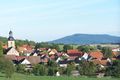
 View from the Bibra viaduct
|
|
Queienfeld is a village in the southern district of Schmalkalden-Meiningen in Thuringia . Since December 1, 2007, the formerly politically independent municipality has been part of the Grabfeld municipality .
location
Queienfeld is located on the Queienberg . The Bibra flows through the village . In the north lies the Thuringian Forest , southwest the Rhön . In between is the Grabfeld, in which Queienfeld once settled in its corridor not far to the east of the federal highway 71 and the state road 2668 and the district road 60.
history
Queienfeld was first mentioned in 1057 as Quiunfelt . The place initially belonged as an exclave to the possession of the Würzburg monastery in the county of Henneberg .
Around 1100 there was a chapel dedicated to the Virgin Mary on the 506 meter high Queienberg , which was used as a pilgrimage chapel until the end of the 15th century . The village church was built from the stones of this chapel between 1719 and 1721 .
During the construction of the A 71 , archaeologists discovered traces of prehistoric settlement that indicated that it was already around 600 years BC. There were extensive settlements between Queienberg and Büchelberg.
In 1435 the Bishop of Würzburg pledged the place to the Counts of Henneberg -Schleusingen. The pledge was not redeemed until 1495. In 1542 Queienfeld came as part of the Würzburg exclave Meiningen in exchange to the Counts of Henneberg-Schleusingen. After their extinction, Queienfeld and the Meiningen office came to the Wettins in 1583 . The highest jurisdiction over the place was initially with the Mellrichstadt center , later Queienfeld was not subject to a central association, but the high jurisdiction of the Meiningen office.
As a result of the "Schalkau Exchange Agreement", the place came to the Duchy of Saxony-Hildburghausen in 1723 and was affiliated to the office of Behrungen . After the reorganization of the Ernestine duchies , the place came back to Saxony-Meiningen as part of the Behrungen office in 1826.
In 2007 Queienfeld celebrated its 950th anniversary from August 17th to 26th. The main festivities took place on the traditional forest festival site, which also features a Luther linden tree planted in 1830 and two peace linden trees from 1855.
District Council

The Queienfeld district council consists of five councilors.
District Mayor
The last honorary mayor before the incorporation was Carmen Rodeck ( Die Linke ). She was elected on June 27, 2004. The current mayor of the district is Martin Kais.
Regular events
- Forest festival, the open-air festival always takes place at Whitsun.
- Forest service under the lime trees on Queienberg every first Sunday in May
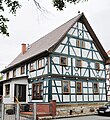
Half-timbered house by the church
In the background the Great Gleichberg


Economy and Infrastructure
From 1893 to 1970 Queienfeld had a stop on the Rentwertshausen – Römhild railway line .
Personalities
- Johann Caspar Hartung (1622–1725), German builder
- Wilhelmine Eichler (1872–1937), politician (SPD, KPD)
Individual evidence
- ↑ StBA Area: changes from 01.01. until December 31, 2007
- ↑ Outline of a historical-geographical description of the county of Henneberg, as a correction of the erroneous reports from this country in the general descriptions of the earth: VI. The princely house of Saxony-Hildburghausen. In: Journal of and for Franconia Description of the Henneberg office Behrungen. 1791, Retrieved June 29, 2019 (reproduced on Wikisource ).
Web links

Bauerbach | Bores | Berkach | Bibra | Exdorf with Obendorf | Jüchsen | Nordheim | Queienfeld | Rentwertshausen | Schwickershausen | Wölfershausen | Wolfmannshausen