
Röderbach (Aschaff)
|
Röderbach (upper course: Haibach ) |
||
 The Röderbach in front of Aschaffenburg |
||
| Data | ||
| location |
Spessart
|
|
| River system | Rhine | |
| Drain over | Aschaff → Main → Rhine → North Sea | |
| source | at Haibach 49 ° 58 ′ 9 ″ N , 9 ° 12 ′ 18 ″ E |
|
| Source height | 255 m above sea level NHN | |
| muzzle | at Goldbach in the Aschaff coordinates: 49 ° 59 '26 " N , 9 ° 10' 18" E 49 ° 59 '26 " N , 9 ° 10' 18" E |
|
| Mouth height | 130 m above sea level NHN | |
| Height difference | 125 m | |
| Bottom slope | 31 ‰ | |
| length | 4 km | |
| Catchment area | 4.8 km² | |
The Röderbach (in the upper Haibach ) is a left tributary of the Aschaff in the Bavarian Spessart .
Surname
The basic word in " Haibach " is Old High German Hege and means hedge . Haibach originally means Heckenbach or Grenzbach . The stream gave its name to the community of the same name.
geography
course
The Röderbach rises as Haibach in the village of the same name Haibach . It flows in a north-westerly direction between Schellberg and Hasenkopf through Haibacher Switzerland to the Schellenmühle at the foot of the Gartenberg (309 m). There the Haibach crosses the border to the city of Aschaffenburg and bears the name Röderbach. This then flows over a fork in the stream , where the left arm, which has been heaped up and dug up as an open channel , is completely led into the pheasantry when the water level is low in front of a weir . With normal flow, both arms of the stream run further north and unite in the Goldbach municipality above Österreicher Strasse. The Röderbach then crosses under the Österreicher Straße and the route of the Main-Spessart-Bahn as well as the driveway to the federal motorway 3 (junction 59 Aschaffenburg Ost ) and flows into the Aschaff .
The part of the Röderbach branched off into the pheasantry feeds the lake there and flows outside of the pheasantry, piped and in a culvert under the ditch of the Miltenberger railway through to the grandmother meadow . There the water from the Kühruhgraben in the Hannewackersee is supplied to him. The piping continues to the so-called Muttersee, a small pond on the edge of the Schöntal landscape garden . The piping on the Großmutterwiese was removed in a renaturation project and the Röderbach exposed again. In the Schöntal, the stream serves as a fresh water inflow for the Muttersee, the Schöntal Canal and the lake around the Schöntal ruins. Its outflow, formerly called Leergraben , still flowed in an open city moat along the historic city wall to the west until the 19th century and reached the Löhergraben at the level of today's parking garage Löherstrasse. It flows into the Main under the Willigis Bridge . Today the former Leergraben and the former Löhergraben are completely piped.

The Röderbach in the pheasantry
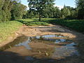
The dry stream bed in front of the confluence with the Aschaff

Estuary into the Aschaff


Aschaff river system
See also
Web links
Individual evidence
- ↑ a b c d BayernAtlas of the Bavarian State Government ( notes )
- ↑ Length was determined from the source to the confluence with the Aschaff. The stretch of the river via Fasanerie, Großmutterwiese and Schöntal to the Main is 6.4 km.
- ^ Wolf-Armin von Reitzenstein : Lexicon of Franconian place names. Origin and meaning . Upper Franconia, Middle Franconia, Lower Franconia. CH Beck, Munich 2009, ISBN 978-3-406-59131-0 , p. 93 ( limited preview in Google Book search).
- ↑ Main-Echo July 5, 2020: The outflow of the Hannewackeldudelsee is now a natural stream bed
- ↑ Historical map: floor plan of the city of Aschaffenburg after its parishes were divided in March 1809