Salt soils
|
Salt soils
City of Lollar
Coordinates: 50 ° 40 ′ 58 ″ N , 8 ° 41 ′ 4 ″ E
|
|
|---|---|
| Height : | 175 m above sea level NHN |
| Area : | 5.91 km² |
| Incorporation : | December 31, 1971 |
| Postal code : | 35457 |
| Area code : | 06406 |
|
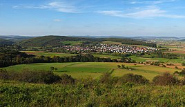
View from the south from the mountain Altenberg
|
|
Salzboden is a district of the city of Lollar in the central Hessian district of Gießen . In addition to the village of Salzböden, the Schmelz settlement (in the northwest) is also part of the district.
geography
Salzboden lies on the Salzböde shortly before it flows into the Lahn near Odenhausen .
history
Salt soils were first mentioned in writing in 775. The church in Salzboden was built in the 13th century as a defense tower and in 1600 an eastern choir was added.
Territorial reform
The municipality of Salzboden, which belonged to the district of Wetzlar , was incorporated into the municipality of Lollar on December 31, 1971 as part of the regional reform in Hesse .
Territorial history and administration
The following list gives an overview of the territories in which salt soils were located and the administrative units to which it was subordinate:
- 750/779: Lahngau
- 1585: Holy Roman Empire , County of Nassau-Weilburg , Gleiberg Office
- before 1806 Holy Roman Empire, Principality of Nassau-Weilburg, Oberamt Atzbach , Amt Gleiberg
- from 1806: Duchy of Nassau , Amt Gleiberg
- 1816: Kingdom of Prussia , Rhine Province , Region of Koblenz , Kreis Wetzlar
- from 1867: North German Confederation , Kingdom of Prussia, Rhine Province, Koblenz District, Wetzlar District
- from 1871: German Empire , Kingdom of Prussia, Rhine Province, Koblenz District, Wetzlar District
- from 1918: German Empire, Free State of Prussia , Rhine Province, Koblenz District, Wetzlar District
- from 1932: German Empire, Free State of Prussia, Province of Hessen-Nassau , Administrative Region of Wiesbaden , District of Wetzlar
- from 1944: German Empire, Free State of Prussia, Nassau Province , Wetzlar District
- from 1945: American zone of occupation , Greater Hesse , Wiesbaden district, Wetzlar district
- from 1949: Federal Republic of Germany , State of Hesse , Wiesbaden district, Wetzlar district
- from 1968: Federal Republic of Germany, State of Hesse, administrative district Darmstadt , district of Wetzlar
- on December 1, 1971, Salzboden was incorporated into Lollar.
- 1972: Federal Republic of Germany, Land Hessen, Darmstadt Region , district casting
- from 1977: Federal Republic of Germany, State of Hesse, Darmstadt administrative district, Lahn-Dill district
- from 1979: Federal Republic of Germany, State of Hesse, Darmstadt district, Gießen district
- from 1981: Federal Republic of Germany, State of Hesse, Gießen district, Gießen district
Population development
Occupied population figures up to 1970 are:
- 1834: 427 Protestant residents, 78 houses
- 1961: 567 Protestant (= 74.61%), 185 Catholic (= 24.34%) residents
| Salt soils: Population from 1834 to 1970 | ||||
|---|---|---|---|---|
| year | Residents | |||
| 1834 | 427 | |||
| 1840 | 457 | |||
| 1846 | 486 | |||
| 1852 | 489 | |||
| 1858 | 486 | |||
| 1864 | 487 | |||
| 1871 | 499 | |||
| 1875 | 494 | |||
| 1885 | 470 | |||
| 1895 | 464 | |||
| 1905 | 504 | |||
| 1910 | 503 | |||
| 1925 | 498 | |||
| 1939 | 502 | |||
| 1946 | 707 | |||
| 1950 | 749 | |||
| 1956 | 704 | |||
| 1961 | 760 | |||
| 1967 | 803 | |||
| 1970 | 841 | |||
| Data source: Historical municipality register for Hesse: The population of the municipalities from 1834 to 1967. Wiesbaden: Hessisches Statistisches Landesamt, 1968. Other sources: | ||||
Attractions
In Salzboden there are two mill guest houses, the Schmelzmühle (also called Kronauer Hof) and the Schönemühle. A little south of the smelting mill are the ruins of the former Gronau castle from the Carolingian era .
Personalities
- Fredrik Vahle (* 1942), songwriter and author, lives in salt soils
- Ludwig Bodenbender (1891–1962), politician
Individual evidence
- ↑ "Current data" on the city of Lollar's website , accessed in July 2016.
- ↑ Information on the historical church
- ↑ K.-H. Gerstenmeier (1977): Hessen. Municipalities and counties after the regional reform. A documentation. Melsungen. P. 305
- ↑ a b c salt soils, district of Giessen. Historical local dictionary for Hessen. (As of May 24, 2018). In: Landesgeschichtliches Informationssystem Hessen (LAGIS).
- ^ Michael Rademacher: German administrative history from the unification of the empire in 1871 to the reunification in 1990. State of Hesse. (Online material for the dissertation, Osnabrück 2006).
- ^ Kronauer Hof, district of Giessen. Historical local dictionary for Hessen. (As of July 23, 2012). In: Landesgeschichtliches Informationssystem Hessen (LAGIS).
- ↑ Information on the Gronau Castle
Web links
- Internet presence of the city of Lollar
- Salt soils, district of Giessen. Historical local dictionary for Hessen. In: Landesgeschichtliches Informationssystem Hessen (LAGIS).
- Literature on salt soils in the Hessian Bibliography


