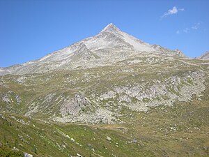
Rauhkofel
| Rauhkofel | ||
|---|---|---|
|
Rauhkofel from the Waldner Alm |
||
| height | 3251 m above sea level A. | |
| location | Tyrol , Austria and South Tyrol , Italy | |
| Mountains | Zillertal Alps | |
| Dominance | 7.2 km → Reichenspitze | |
| Notch height | 593 m ↓ Heiliges Geistjöchl | |
| Coordinates | 47 ° 4 ′ 33 " N , 12 ° 5 ′ 30" E | |
|
|
||
| First ascent | 1853 by two locals from Prettau | |
| Normal way | From Prettau via Waldner See and Südgrat ( I ) | |
The Rauhkofel or Rauchkofel ( Italian. Monte Fumo ) is a 3251 m above sea level. A. high mountain in the main ridge of the Zillertal Alps , which forms the border between the Austrian state of Tyrol and the Italian province of South Tyrol . The name of the mountain comes from its rough - dialect smoke - appearance, which gives it the granite blocks that form the summit structure. The Rauhkofel towers considerably above the neighboring peaks in the main ridge and is the best vantage point in the eastern Zillertal Alps. The east and south ridge of the Rauhkofel are assigned to the main ridge of the Zillertal Alps. Another ridge runs from the summit to the northwest, in the further course of this ridge is the Kleinspitze (3172 m) just under two kilometers away. To the north of the summit are the remains of the Rauhkofelkees. At the southwest foot of the summit is the Waldner See, the largest lake in the Ahrntal .
Increase opportunities
The summit is climbed almost exclusively from the South Tyrolean side, but the ascent from there is also extremely long. At the turn of the 20th century, the Lausitz section of the German and Austrian Alpine Club built a hut in the south of the mountain and set up a path over the south ridge. The hut has fallen into disrepair, parts of the path have been preserved and are part of today's usual ascent path.
The most common ascent leads from Prettau in the Ahrntal via the Waldneralm and Waldnersee to the southern ridge of the mountain. Alternatively, you can get here from Kasern , the closest town in the Ahrntal Valley, via the Starklalm and the Marchsteinboden. On Südsporn of the mountain, about 3,000 meters above sea level, the Weganlage ends, the further increase via coarse boulders and patches of snow, partly in the flank the west of the ridge, but up to the top mark . The ascent takes about 5 hours.
Literature and map
- Hanspaul Menara : The most beautiful 3000m peaks in South Tyrol. 70 worthwhile alpine tours. Athesia, Bozen 2014, ISBN 978-88-8266-911-9
- Richard Goedeke : 3000 meters in the northern Alps. Bruckmann, Munich 2004, ISBN 3-7654-3930-4
- Dieter Seibert: Light 3000s. The 99 most beautiful tours with a path. Bruckmann Verlag, Munich 2008, ISBN 978-3-7654-5011-2
- Eugen E. Hüsler: Tauferer Ahrntal with Fundres mountains. Bergverlag Rother, 3rd edition, Munich 2009, ISBN 978-3-7633-4186-3
- Topographic hiking map, Ahrntal / Rieserferner Group , sheet 035, 1: 25,000, Casa Editrice Tabacco, ISBN 88-8315-035-X
Individual evidence
- ↑ Eberhard Jurgalski : Complete table of summits in the Alps separated by 590 meters of re-ascent , December 12, 2008.
- ↑ a b c Hanspaul Menara: South Tyrolean summit hikes . Page 196ff, see literature
- ↑ Federal Office for Metrology and Surveying Austria: Rauchkofel on the Austrian Map online (Austrian map 1: 50,000) .
- ↑ Goedecke: 3000 m in the Northern Alps. Page 155, see literature

