
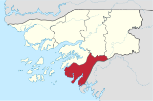
Tombali region
| Tombali region | |
|---|---|
  |
|
| Basic data | |
| Country | Guinea-Bissau |
| Capital | Buba |
| surface | 3736 km² |
| Residents | 91,089 (2009 census) |
| density | 24 inhabitants per km² |
| ISO 3166-2 | GW-TO |
 |
|
Coordinates: 11 ° 15 ′ N , 15 ° 0 ′ W
Tombali is an administrative region in Guinea-Bissau with about 91,000 inhabitants. The capital of this southernmost region of the country is Catió with around 9,000 inhabitants.
The region is geographically and additionally due to the poor road connections as particularly remote, but also as particularly original. The jungle has been preserved particularly well here.
Mention is in particular the natural park Parque Natural de Cantanhez the Florestas . With its naturally forested 1,057 km² it is one of the 12 most important WWF ecoregions on earth for the WWF .
Further inland, the landscape of the mostly water-rich, particularly green region changes into savannah .
Administrative division
The Tombali region is divided into four sectors :
economy
The water-rich region is economically determined by fishing and agriculture. In particular the mango trees and oil palms , which are widespread here , and the naturally irrigated rice fields represent the economic basis of the region.
Web links
Individual evidence
- ↑ a b Website of the Guinea-Bissaus Statistical Office ( INE ), Table 1.2 (p. 11), PFF retrieved on November 26, 2017
- ↑ a b c Joana benzinho, Marta Rosa: À Descoberta da Guiné-Bissau . , Afectos com Letras / EU , Pombal 2015, ISBN 978-989-20-6252-5 , p. 93 ff.