Bissau
| Bissau | ||
|---|---|---|
|
|
||
| Coordinates | 11 ° 52 ′ N , 15 ° 36 ′ W | |

|
||
| Basic data | ||
| Country | Guinea-Bissau | |
| Autonomous sector | Bissau | |
| ISO 3166-2 | GW-BS | |
| Residents | 407,424 (2007) | |
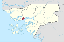
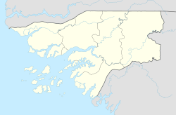
Bissau [ bɪˈsaʊ̯ ] is the capital of the West African state of Guinea-Bissau . In 2007 Bissau had around 410,000 inhabitants. The city is the administrative, political and economic center of the country. It has the country's only international airport and deep-sea port. Administratively, the city forms the Autonomous Sector Bissau , which borders the administrative regions of Oio and Biombo .
geography
The coast of Guinea is generally very indented - numerous estuaries extend deep into the interior. Due to the large tidal range , practically the entire coastal zone is covered with mangrove forests. Bissau is also surrounded by rivers and swampy mangrove areas, which make it an island. The city is located on the northern bank of the Rio Geba , which flows into the Atlantic Ocean in an approximately 10 km wide estuary. The islands of the Bissagos Archipelago lie off the coast of Bissau .
Economy and Infrastructure
economy
Since the city is the country's commercial center, almost all imports (food and consumer goods) and exports (cashew nuts and hardwoods) are handled via Bissau . The former Portuguese city center (Praça) is primarily home to the ministries, banks, restaurants, hotels and administrative facilities, while private trade takes place in the Bandim market on the city motorway and in neighboring areas. The state and the aid organizations are the largest employers. However, a large part of the population earns a living in retail. The most important trading centers are the more than 25 local city markets in the respective residential areas.
Infrastructure
The infrastructure, which was already weak, was further destroyed in the civil war of 1998/99 . Only the important connecting and arterial roads and the streets in the city center are asphalted.
Electricity and water supply
The public electricity and water supply is also limited to the city center and only works there sporadically. Larger shops and hotels organize the supply privately. As one of the last capitals in the world, Bissau is almost completely in the dark at night.
Urban planning
Most of the public buildings are in a bad condition, but many buildings in the rest of the old town are also falling into decay.
traffic
Local transport in Bissau is privately owned. There are almost exclusively shared taxis and minibuses , so-called Toka-Tokas. The shared taxis circulate freely around the city, while the Toka-Toka traffic runs on set routes between the outskirts and the city center.
All regions of the country can be reached by long-distance transport from Bissau. There are currently two bus stations in Bissau. The central bus station is on the city motorway near the National Bank. From there there are connections to almost all parts of the country as well as international connections to Gambia and Senegal . Traffic with the Biombo region is handled by a separate bus station in Bairro Belém.
The international Osvaldo Vieira International Airport is approximately 9 km from the city center on the north-western outskirts. There are scheduled connections to Casablanca , Dakar and Lisbon .
From the port in the city center there are regular connections to the Bissagos Archipelago , most of which are handled by pirogues .
history
Early days and foundation until 1753
Portuguese sailors and traders reached the upper Guinea coast from 1446 and set up numerous trading bases there. The beginnings of Bissau go back to the 16th century - however, an exact date of foundation is not known. The first written testimony probably comes from the year 1594, which does not refer to the place, but to an ethnic group who called themselves "Bisãos" ( Pepel ). Urban development can be divided into five phases:
Portuguese / Cape Verdean traders have settled in Bissau since the 16th century . From the beginning they were in conflict with the local Pepel population, with whom wars broke out. The motives for the settlement were mostly economic in nature. Slaves, ivory and beeswax were traded. The so-called Lançados (illegal Portuguese traders) and Grumetes (Christianized Africans; actually Portuguese cabin boys ) successfully undermined the Portuguese crown's monopoly of trade.
The granting of the captaincy statute in 1692 can be seen as the actual hour of birth of Bissau, as the city was officially connected to Portugal from this point in time. Construction of a fort began in 1696, but it was destroyed again in 1707 by order from Portugal. The place was officially abandoned. In the period that followed, the French , who also tried several times to build a fort, dominated the place.
Consolidation from 1753 to 1913/15
In 1753, the Portuguese began again with the construction of a fort, which could not be completed until 1775. The slave trade dominated the place until the 1850s .
In 1852 Bissau became the capital of the Guinea district, but lost this position in 1879 to Bolama on the island of the same name , which became the capital of the newly created province of Portuguese Guinea .
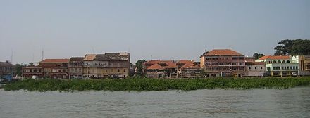
Even at the beginning of the 20th century, Bissau was only a small place consisting of a fort, an adjoining walled merchant settlement, a harbor and a few administrative buildings. Only after the suppression of the last resistance of the local population in 1913/15 did the place begin to grow more rapidly.
First expansion period from 1913 / 15-1941
In the 1920s, after the first urbanization plan had been drawn up, parts of the current center were built. The village of the Grumetes was rebuilt on the periphery. After the Germans had control of the trade at the beginning of the 20th century , French trading houses took over again . Portugal only succeeded in enforcing its own trade monopoly in the 1930s. From 1936 preparations began to transfer the capital to Bissau.
Second expansion period from 1941–1974
On December 19, 1941, the capital was moved from Bolama to Bissau. As a result, further administrative and farm buildings were built. In 1953 the first road in Bissau was paved. The European city center was created in its current size. From the end of the 1950s there was another modernization and expansion of the infrastructure in general. The population of Bissau rose from around 18,000 in 1950 to around 70,000 in 1970, because after the outbreak of the liberation struggle in 1963, many people sought refuge in the city. Bissau was directly attacked twice during the War of Liberation , in 1968 and 1971.
Third expansion period from 1974 until today

On September 24, 1973, the Guinean independence movement PAIGC declared Guinea-Bissau with the capital Madina do Boé unilaterally independent. After recognition by Portugal on September 10, 1974, the capital was moved back to Bissau. As a result, the city developed into the country's political and economic center.
The failed development policy of the PAIGC, which wanted industrialization in the 1970s and largely neglected the interior of the country, contributed to the continued strong population growth in the city, which could not keep up with urban planning. The majority of government and aid agency activities were confined to Bissau.
Nevertheless, an urbanization plan was never implemented. The city grew and grew along the arterial roads. In 1990 the population was estimated at around 200,000. During the civil war of 1998/99 there was severe damage to the already weak infrastructure - the front line ran through the city's only industrial zone. Much of the population left the city during the war and sought refuge with family members in the countryside.
religion
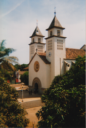
The population of Bissau is religiously mixed. Since the proportion of people who are influenced by Portuguese culture is particularly high here, there is a strong minority of Catholics. The city is the seat of the diocese of Bissau .
In terms of numbers, however, the majority are Muslims, who are mostly members of the country's Islamic ethnic groups, to whom immigrants from neighboring countries have recently come.
A part of the population that is difficult to determine is committed to traditional African religions.
Protestantism is present in the form of Pentecostal churches , some of which have their origins in Brazil.
Sports

Soccer is the most popular sport in the country. Bissau is home to the two most successful clubs in the first division, the Campeonato Nacional da Guiné-Bissau : the record champions Sporting Clube de Bissau , a subsidiary of the Portuguese club Sporting Lisbon , and the hardly less successful Sport Bissau e Benfica , a subsidiary of the Portuguese Benfica Lisbon .
Other clubs in the capital include Mavegro FC , FC Cuntum , the three-time champions União Bissau , the military club Estrela Negra de Bissau , the Ajuda Sport de Bissau , which is also highly committed to culture and society , and Sport Portos de Bissau , the Werkself of the port of Bissau.
The clubs usually play their home games in one of the city's two main stadiums , the National Stadium Estádio 24 de Setembro or the Estádio Lino Correia .
The Amílcar-Cabral-Cup , a West African national tournament, took place in Bissau in 1979, 1988 and 2007.
Climate table
| Bissau | ||||||||||||||||||||||||||||||||||||||||||||||||
|---|---|---|---|---|---|---|---|---|---|---|---|---|---|---|---|---|---|---|---|---|---|---|---|---|---|---|---|---|---|---|---|---|---|---|---|---|---|---|---|---|---|---|---|---|---|---|---|---|
| Climate diagram | ||||||||||||||||||||||||||||||||||||||||||||||||
| ||||||||||||||||||||||||||||||||||||||||||||||||
|
Average monthly temperatures and precipitation for Bissau
Source: wetterkontor.de
|
|||||||||||||||||||||||||||||||||||||||||||||||||||||||||||||||||||||||||||||||||||||||||||||||||||||||||||||||||||||||||||||||||||||||||||||||||||||||||||||||||||||||||||||||||||||||||||||||||||
Town twinning
-
 Senegal : Dakar
-
 Portugal : Águeda (since 1995)
 -
 Portugal : Lisbon (since 1983)
 -
 Portugal : Moura (since 1997)
 -
 Portugal : Rio Maior (cooperation agreement since 2015)
 -
 Portugal : Sintra (since 1997)
sons and daughters of the town
- Luís Cabral (1931–2009), first President of Guinea-Bissau
- Henrique Medina Carreira (1930–2017), Portuguese politician and lawyer, Minister of Finance 1976–1978
- João Bernardo Vieira (1939–2009), long-time President of Guinea-Bissau
- Veríssimo Correia Seabra (1947–2004), brief head of state in 2003
- José Carlos Schwarz (1949–1977), musician, poet and diplomat
- Zinha Vaz (* 1952), women activist and politician
- Julio Herbert Lopes (1954–2019), Cape Verdean diplomat and politician
- Nuno Severiano Teixeira (* 1957), Portuguese politician, multiple minister
- Adão da Silva (* 1957), football player
- Antonieta Rosa Gomes (* 1959), politician
- Fátima Djarra Sani (* 1968), women's rights activist
- Helena Ferro de Gouveia (* 1971), Portuguese journalist, lecturer and author
- Nélson Gama (* 1972), Portuguese football player
- Daniel Kenedy (* 1974), football player
- Almami Moreira (* 1978), Portuguese football player
- Dionísio Mendes Fernandes (* 1981), football player
- Sufrim Lopes (born 1981), football player
- Inzaghi Donígio (* 1985), football player
- Yannick Djaló (* 1986), football player
- Ivanildo Soares Cassamá (* 1986), football player
- Éderzito António Macedo Lopes (* 1987), football player
- Leocísio Sami (* 1988), Portuguese-Guinea-Bissau football player
- Holder da Silva (* 1988), Olympic athlete
- Amido Baldé (* 1991), soccer player
- Esmaël Gonçalves (* 1991), Portuguese football player
- Danilo Pereira (* 1991), football player
- Aladje (* 1993), Portuguese football player
- Agostinho Cá (* 1993), football player, Portuguese national player
- Toni Silva (* 1993), Guinea-Bissau-Portuguese football player
- Armindo Tué Na Bangna, Bruma (* 1994), soccer player, Portuguese national player
- Edgar Ié (* 1994), soccer player, Portuguese U21 international
- Alfa Semedo (born 1997), football player
- Madiu Bari (* 1998), Portuguese football player
- Toni Gomes (* 1998), soccer player
- José Gomes (* 1999), Portuguese football player
- Domingos Quina (* 1999), Portuguese football player
- Romário Baró (* 2000), Portuguese football player
- Ansu Fati (* 2002), Spanish soccer player
Nuno Severiano Teixeira (left, with US Secretary of Defense Robert Gates , June 8, 2007)
Éderzito Lopes in the Sporting Braga jersey
Agostinho Cá in the jersey of the Portuguese national team
Toni Silva in the CSKA Sofia jersey (2013)
literature
- Josef Ernst Kasper: Bissau. Livelihood securing strategies in a West African city . Peter Lang, Bern 1995, ISBN 3-906752-02-X .
Web links
Individual evidence
- ↑ Instituto Nacional de Estatística ( MS Excel ; 31 kB)
- ^ The Economic Intelligence Unit: Country Report Guinea Bissau. October 2009, p. 25ff
- ↑ Kasper, Bissau , p. 70ff.
- ↑ Kasper, Bissau , pp. 74ff.
- ↑ Kasper, Bissau , pp. 87ff.
- ↑ Kasper, Bissau , p. 92ff
- ↑ Joshua Forrest, Richard Lobben: Historical Dictionary of the Republic of Guinea-Bissau. Scarecrow Press, London 1988, p. 30.
- ^ Manfred Stoppok: Bissau - urban development and history ; October 27, 2010
- ↑ Overview of the city partnerships of Portuguese cities in Guinea-Bissau , umbrella organization of the Portuguese district administrations ANMP, accessed on January 5, 2018


