Riding stone
| Riding stone | ||
|---|---|---|
| height | 1516 m | |
| location | District of Miesbach , Bavaria , Germany ; Tyrol , Austria | |
| Mountains | Mangfall Mountains | |
| Dominance | 1.37 km → Platteneck | |
| Notch height | 137 m ↓ notch to the Platteneck | |
| Coordinates | 47 ° 35 '3 " N , 11 ° 40' 40" E | |
|
|
||
The Reitstein is a 1516 m (according to AVF 1515 m ) high summit in the Mangfall Mountains , Bavarian Prealps , on the border between Bavaria ( Kreuth municipality ) and Tyrol ( Achenkirch municipality ).
topography
The mountain lies in the ridge that extends west of the Blauberge and is bounded in the north by the Weißach with the federal highway 307 , which stretches from the Schildenstein ( 1613 m ) to the west and extends over the Platteneck ( 1618 m ), the Reitstein, the Reitberg ( 1455 m ) and the Ameiskopf ( 1302 m ) above the Kaiserwacht on Achenseestraße .
Alpinism
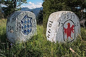
The mountain, which offers a comprehensive view, has a well-preserved border stone from the 16th century with a Tyrolean eagle and the Bavarian diamonds . There is also a summit cross on the summit, a little below is a derelict hut. The Reitstein can be climbed from the Achental from Gasthaus Hagen im Wald on an unmarked path over the Reitbergalm in around two and a half hours. From the Achenpass , an unmarked trail leads in around three hours over the Bavarian Reitbergalm to the summit, another from Bayerwald over the Bodigbergalm. The transition to the Platteneck can be reached in an hour without any stairs.
literature
- W. and G. Zimmermann: Alpine Club Leader Bayerische Voralpen Ost , 2nd edition, Bergverlag Rudolf Rother, Munich 1980, ISBN 3-7633-1103-3
- Bavarian Land Surveying Office: Topographic map 1: 50,000 sheets L 8336 Miesbach
- Federal Office for Metrology and Surveying: Austrian Map 1: 50000 Sheet 88 Achenkirch


