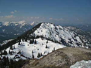
Platteneck (Kreuth)
| Platteneck | ||
|---|---|---|
| height | 1618 m | |
| location | District of Miesbach , Bavaria , Germany | |
| Mountains | Bavarian Prealps | |
| Dominance | 1.9 km → Wichtlplatte | |
| Notch height | 168 m ↓ saddle between Schildenstein and Wichtlplatte | |
| Coordinates | 47 ° 35 '29 " N , 11 ° 42' 49" E | |
|
|
||
The Platteneck in the municipality of Kreuth is a 1618 m (according to AVF 1633 m ) high summit in the Bavarian Prealps right on the border between Bavaria and Tyrol .
topography
The mountain lies in the ridge that extends west of the Blauberge and is bounded in the north by the Weissach with the federal road 307, which stretches from the Schildenstein ( 1611 m ) to the west and continues to the Reitstein ( 1515 m ).
Alpinism
The ascent can be done in various ways via the Königsalm, which can be reached from Wildbad Kreuth or from the Winterstube near Bayerwald, as well as from the Gufferthütte south along the Blauberge via the Schildenssteinalm.
Totengraben natural forest reserve
The forest reserve dead trench ( 47 ° 35 '37.7 " N , 11 ° 41' 46.7" O ) is a 46.7 hectare large area in the western slopes of the Mangfall mountains on the north slope of Plattenecks. It is located in the administrative district of Upper Bavaria and includes a state-owned forest area. It is one of the reserves designated in 1978 under the Forest Act for Bavaria (BayWaldG), Article 12a . As a small-area remnant of a primary forest, the forest is one of the relict forests . The mixed mountain forest in the area consists of sycamore , spruce , fir and beech .
Due to the difficult-to-access terrain, it was not possible to ridge of wood here during the salt flats . In a basin about 5 hectares in size and probably also in the area above, the clear-cutting that was prevalent during the saline season was therefore not feasible. On the other hand, a dilapidated Triftklause suggests a former use of the remaining reserve area.
Until secularization , wood in the region was used for glass production in the glassworks and for the brewery in Tegernsee . After that, the wood was used to supply the Rosenheim saltworks .
literature
- W. and G. Zimmermann: Alpine Club Leader Bayerische Voralpen Ost , 2nd edition, Bergverlag Rudolf Rother, Munich 1980, ISBN 3-7633-1103-3
- Bavarian Land Surveying Office: Topographic map 1: 50,000 sheets L 8336 Miesbach
Individual evidence
- ↑ Database of natural forest reserves in Germany
- ↑ a b c The primeval forest relict Totengraben in the Bavarian Alps . Bavarian State Institute for Forests and Forestry. Retrieved April 19, 2014.


