Ridala
| Ridala | |||
|
|||
| State : |
|
||
| Circle : |
|
||
| Founded : | 1992 | ||
| Coordinates : | 58 ° 57 ' N , 23 ° 39' E | ||
| Area : | 253.4 km² | ||
| Residents : | 3,412 (January 1, 2013) | ||
| Population density : | 13 inhabitants per km² | ||
| Time zone : | EET (UTC + 2) | ||
| Telephone code : | (+372) 047 | ||
| Postal code : | 90401 | ||
| Community type: | former rural community | ||
| Structure : | 58 villages | ||
| Postal address : | Tallinna mnt 83 90401 Uuemõisa |
||

|
|||
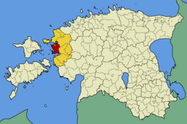
Ridala (German Röthel ) is a former rural community in Lääne County in the west of the Republic of Estonia . In 2017, Ridala was incorporated into the municipality of Haapsalu .
description
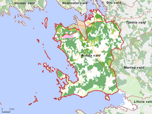
The area of the rural community has an area of 253.4 km² and is located on the Baltic Sea . It also included 78 islands, of which Tauksi is the largest. The population was 3,017 (2008).
Ships to the Estonian islands of Hiiumaa and Vormsi run regularly from the ferry port in Rohuküla .
Villages
In addition to the main town of Uuemõisa belonged to the rural community of the villages Aamse , Allika , Ammuta , Emmuvere , Erja , Espre , Haeska , Herjava , Hobulaiu , Jõõdre , Kabrametsa , Kadaka , Käpla , Kaevere , Kiideva , Kiltsi , Kiviküla , Koheri , Koidu , Kolila , Kolu , Laheva , Lannuste , Liivaküla , Litu , Lobe , Metsaküla , Mäeküla , Mägari , Nõmme , Panga , Paralepa , Parila , Puiatu , Puise , Pusku , Põgari-Sassi , Rohense , Rohuküla , Rummu , Saanika , Saardu , Sepaküla , Sinalepa , Suure -Ahli , Tammiku , Tanska , Tuuru , Uuemõisa , Üsse , Uneste , Valgevälja , Varni , Vilkla , Võnnu , Väike-Ahli and Vätse .
photos
Manor of Uuemõisa
Ridala Church in Kolila Village
Ruins of the Kiltsi Manor
Ruins of Ungru Castle
Ruins of the Sinalepa Orthodox Church
Ornithological observation tower near Haeska
Ice fields at the port of Rohuküla
Monument to Tsar Alexander III in Pullapää
Boat harbor in Puise
Baltic Sea near Lõbe


