
Riedgraben (Fauerbach)
| Riedgraben | ||
 River system of the USA |
||
| Data | ||
| Water code | DE : 24848692 | |
| location |
Rhine-Main lowlands
|
|
| River system | Rhine | |
| Drain over | Fauerbach → Usa → Wetter → Nidda → Main → Rhine → North Sea | |
| source | in the eastern Hintertaunus northwest of Butzbach - Fauerbach in front of the height 50 ° 23 ′ 44 ″ N , 8 ° 37 ′ 48 ″ E |
|
| Source height | 275 m above sea level NN | |
| muzzle | east of Butzbach - Fauerbach vor der Höhe in den Fauerbach Coordinates: 50 ° 23 '22 " N , 8 ° 38' 51" E 50 ° 23 '22 " N , 8 ° 38' 51" E |
|
| Mouth height | 208 m above sea level NN | |
| Height difference | 67 m | |
| Bottom slope | 42 ‰ | |
| length | 1.6 km | |
 After almost half a kilometer in the piping, the Riedgraben sees the sunlight again below the large new hall of a courtyard on the eastern edge of Fauerbach vdH |
||
The Riedgraben is a one and a half kilometer long, mostly dry rift system in the eastern Hintertaunus in the district of Butzbach in the Hessian Wetteraukreis . The Riedgraben coming from the north joins the Fauerbach from the left and finally from the west .
geography
course

The Riedgraben rises in two branches in the eastern Hintertaunus to the northwest and above Fauerbach vd Höhe .
The approximately 800 m long upper branch has a hydraulic connection at its highest point to the road ditches on both sides of the district road 15 between Butzbach - Hoch-Weisel and Butzbach - Münster . The approximately half a kilometer long lower branch rises at a height of 264 m from a contained and temporarily pouring spring at the junction of a field path, approximately 200 m east of the K 15.
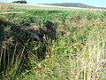
Both branches initially run parallel to the south side of dirt roads at a distance of about 300 m through the field corridor Am Gänsnett to the east. The upper ditch now turns almost 90 ° to the south, then flows about 350 m between the corridor Riedgraben on the right and the corridor An den Brautgärten on the left and then picks up the lower branch on its right side. Below the junction of the two branches, a small hollow has formed in which moisture-loving plants ( stream bungee and rushes ) form a community and indicate that the ditch temporarily carries water.
The combined ditch now runs south-southeast towards the village of Fauerbach and after about 300 meters is piped under the place, about 350 m long as the crow flies. It begins about 40 m north of a tower-like transformer house , which stands at the intersection of Mehl- and Weidengasse ( Grabelicksweg to Butzbach-Münster, there called Fauerbacher Weg ) on the northern outskirts. Although no water flows into the piping at the inlet, it leaves its end below a newly built hall of a courtyard on the eastern outskirts of Fauerbach.
The ditch leads in a straight line to the east and turns for a few meters to the southeast, to flow from the left over part of the ditch flank at a height of 208 m into the Fauerbach approaching from the west .

The upper branch

Source lower branch
Merge both branches

The Riedgraben flows down the Trapezgrabenrand to the confluence with the Fauerbach


Usa River System
Individual evidence
- ↑ Map and legend of the natural areas of Hesse (online copy of Die Naturraum Hessens , Otto Klausing 1988) in the Hessen Environmental Atlas of the Hessian State Office for Environment and Geology
- ↑ Brigitte Schwenzer: Geographical land survey: The natural space units on sheet 139 Frankfurt a. M. Federal Institute for Regional Studies, Bad Godesberg 1967. → Online map (PDF; 4.9 MB)
- ↑ a b Hessenviewer (Geoportal Hessen) of the Hessian State Office for Soil Management and Geoinformation with property mapping ( notes )
- ↑ Water map service of the Hessian Ministry for the Environment, Climate Protection, Agriculture and Consumer Protection ( information )
- ↑ Designation according to the property map at the Hessenviewer
- ↑ Partly incorrect display and dimensions in the WFD viewer of the state of Hesse
- ↑ Is viewed by WFD Hessen as the main hydrological strand
Web links
- Course of the Riedgraben on WFD Viewer Hessen
- Course of the ditch on the DOP viewer